Hancock's Bridge, New Jersey
| Hancock's Bridge, New Jersey | |
|---|---|
| Census-designated place | |
|
| |
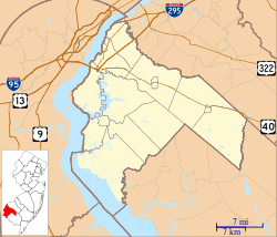
 United States Census Bureau map of ZCTA 08038 Hancock's Bridge, New Jersey | |
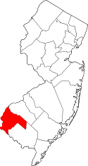
 Hancock's Bridge, New Jersey  Hancock's Bridge, New Jersey  Hancock's Bridge, New Jersey Hancocks Bridge's location in Salem County (Inset: Salem County in New Jersey) | |
| Coordinates: 39°30′20″N 75°27′44″W / 39.50562°N 75.462261°WCoordinates: 39°30′20″N 75°27′44″W / 39.50562°N 75.462261°W[1][2] | |
| Country |
|
| State |
|
| County | Salem |
| Township | Lower Alloways Creek |
| Area[1] | |
| • Total | 0.213 sq mi (0.551 km2) |
| • Land | 0.206 sq mi (0.533 km2) |
| • Water | 0.007 sq mi (0.018 km2) 3.22% |
| Elevation[3] | 3 ft (1 m) |
| Population (2010 Census)[4] | |
| • Total | 254 |
| • Density | 1,234.2/sq mi (476.5/km2) |
| Time zone | Eastern (EST) (UTC-5) |
| • Summer (DST) | Eastern (EDT) (UTC-4) |
| ZIP code | 08038[5] |
| Area code(s) | 856 |
| FIPS code | 3429520[6] |
| GNIS feature ID | 02583999[7] |
Hancock's Bridge (also Hancocks Bridge, without an apostrophe) is a unincorporated community and census-designated place (CDP) located within Lower Alloways Creek Township, in Salem County, New Jersey, United States.[8][9][10][11] As of the 2010 United States Census, the CDP's population was 254.[4] The area is served as United States Postal Service ZIP code 08038.
Geography
According to the United States Census Bureau, Hancocks Bridge had a total area of 0.213 square miles (0.551 km2), including 0.206 square miles (0.533 km2) of land and 0.007 square miles (0.018 km2) of water (3.22%).[1][2]
Demographics
Census 2010
At the 2010 United States Census, there were 254 people, 93 households, and 65.01 families residing in the CDP. The population density was 1,234.2 per square mile (476.5/km2). There were 103 housing units at an average density of 500.5 per square mile (193.2/km2). The racial makeup of the CDP was 97.24% (247) White, 1.57% (4) Black or African American, 0.00% (0) Native American, 1.18% (3) Asian, 0.00% (0) Pacific Islander, 0.00% (0) from other races, and 0.00% (0) from two or more races. Hispanics or Latinos of any race were 0.79% (2) of the population.[4]
There were 93 households, of which 35.5% had children under the age of 18 living with them, 51.6% were married couples living together, 14.0% had a female householder with no husband present, and 30.1% were non-families. 25.8% of all households were made up of individuals, and 14.0% had someone living alone who was 65 years of age or older. The average household size was 2.73 and the average family size was 3.32.[4]
In the CDP, 26.8% of the population were under the age of 18, 10.2% from 18 to 24, 25.6% from 25 to 44, 23.2% from 45 to 64, and 14.2% who were 65 years of age or older. The median age was 39.0 years. For every 100 females there were 101.6 males. For every 100 females age 18 and over, there were 93.8 males.[4]
Historic sites
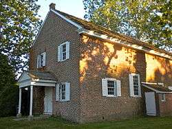
The Hancock House is a historic structure that was the site of the 1778 Hancock's Bridge massacre. Built in 1734 for Judge William and Sarah Hancock, the house featured a blue glazed brick pattern, which gave the year of construction, 1734, and the initials of the couple for whom it was built, 'W S' for William and Sarah. William died in 1762, and passed the house to his son William, also a judge.[12]
References
- 1 2 3 Gazetteer of New Jersey Places, United States Census Bureau. Accessed July 21, 2016.
- 1 2 US Gazetteer files: 2010, 2000, and 1990, United States Census Bureau. Accessed September 4, 2014.
- ↑ U.S. Geological Survey Geographic Names Information System: Hancocks Bridge Census Designated Place, Geographic Names Information System. Accessed February 9, 2013.
- 1 2 3 4 5 DP-1 - Profile of General Population and Housing Characteristics: 2010 Demographic Profile Data for Hancocks Bridge CDP, New Jersey, United States Census Bureau. Accessed February 9, 2013.
- ↑ Look Up a ZIP Code for Hancocks Bridge, NJ, United States Postal Service. Accessed February 9, 2013.
- ↑ American FactFinder, United States Census Bureau. Accessed September 4, 2014.
- ↑ US Board on Geographic Names, United States Geological Survey. Accessed September 4, 2014.
- ↑ GCT-PH1 - Population, Housing Units, Area, and Density: 2010 - County -- County Subdivision and Place from the 2010 Census Summary File 1 for Salem County, New Jersey, United States Census Bureau. Accessed February 9, 2013.
- ↑ 2006-2010 American Community Survey Geography for New Jersey, United States Census Bureau. Accessed February 9, 2013.
- ↑ New Jersey: 2010 - Population and Housing Unit Counts - 2010 Census of Population and Housing (CPH-2-32), United States Census Bureau, August 2012. Accessed February 9, 2013.
- ↑ Locality Search, State of New Jersey. Accessed April 18, 2015.
- ↑ Hancock House, New Jersey Department of Environmental Protection. Accessed December 25, 2008.