Groveton, New Hampshire
| Groveton, New Hampshire | |
|---|---|
| Census-designated place | |
|
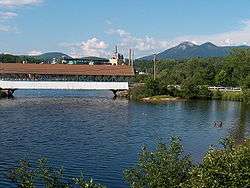
Covered bridge over the Upper Ammonoosuc River in front of former paper mill in Groveton. The Percy Peaks are in the distance. | |
 Groveton  Groveton | |
| Coordinates: 44°35′56″N 71°30′52″W / 44.59889°N 71.51444°WCoordinates: 44°35′56″N 71°30′52″W / 44.59889°N 71.51444°W | |
| Country | United States |
| State | New Hampshire |
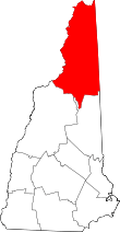
| County | Coos |
| Town | Northumberland |
| Area | |
| • Total | 2.15 sq mi (5.57 km2) |
| • Land | 2.06 sq mi (5.33 km2) |
| • Water | 0.09 sq mi (0.23 km2) |
| Elevation | 883 ft (269 m) |
| Population (2010) | |
| • Total | 1,118 |
| • Density | 543/sq mi (209.6/km2) |
| Time zone | Eastern (EST) (UTC-5) |
| • Summer (DST) | EDT (UTC-4) |
| ZIP code | 03582 |
| Area code(s) | 603 |
| FIPS code | 33-32260 |
| GNIS feature ID | 0867268 |
Groveton is a census-designated place (CDP) in the town of Northumberland in Coos County, New Hampshire, United States. The population was 1,118 at the 2010 census.[1] It is located at the intersection of U.S. Route 3 and New Hampshire Route 110.
The paper mill, which was the primary employer in Groveton, was closed by Wausau Papers in 2008.
Groveton is part of the Berlin, NH–VT Micropolitan Statistical Area.
History
Fort Wentworth
Fort Wentworth was a colonial fort built in 1755 at the junction of the Upper Ammonoosuc River and Connecticut River, in Northumberland, New Hampshire, just downstream from the present site of Groveton.
Paper mill
Diamond International Papers was originally the hub of Groveton. Diamond International was replaced by James River Paper Company, which was followed by Wausau Paper. In 2008 Wausau ceased production in its Groveton mill, which in turn precluded the trains from stopping in Groveton any more. There were plans to turn the mill into a biomass plant, but as of January 2012, plans for buying the mill had fallen through.[2] After an interview with former mill employees, the Town of Northumberland has decided to demolish the mill for scrap metals. With the price of metals at an all-time high, the town would make more money with the metals than waiting for the mill to sell. Plans for the future site include a LNG Plant bringing 80 or so vital jobs to the North Country. As of late 2014 the plans are on hold.
Steam locomotive
A coal-powered steam engine was owned by the Odell Manufacturing Company paper mill for use as a switch engine. Having last seen use in the mid-1960s, it is presently maintained by Wausau Mills and Groveton Paper Board. The Boy Scouts "dress it up" every Christmas and keep it clean.
Speedway 51
In 1964 Riverside Speedway, a 1/4 mile banked oval track, opened up in Groveton. In late 2014 Riverside Speedway was purchased and underwent a name change. Over the next few years the track is planned to undergo many changes to the outdated venue, including a go-kart track paved in the infield. It features weekly racing series and is a popular venue in local auto racing.
The Early Show
Groveton was featured on The Early Show on January 5, 2012. It was a story on the mill and featured Karen Brown of The Early Show and Roger Caron.
Geography
Groveton is located in the northern part of the town of Northumberland in western Coos County at 44°36′3″N 71°30′49″W / 44.60083°N 71.51361°W (44.600868, -71.513525).[3] It lies on the northwest side of the Upper Ammonoosuc River about a mile east of the river's mouth at the Connecticut River, which forms the New Hampshire/Vermont border.
U.S. Route 3 passes through Groveton, leading north 26 miles (42 km) to Colebrook and south 10 miles (16 km) to Lancaster, the Coos County seat. New Hampshire Route 110 branches east from US 3 on the south edge of Groveton and leads east then southeast 26 miles (42 km) to Berlin.
According to the United States Census Bureau, the Groveton CDP has a total area of 2.15 square miles (5.57 km2), of which 2.06 square miles (5.33 km2) is land and 0.089 square miles (0.23 km2), or 4.16%, is water.
Demographics
As of the census[4] of 2000, there were 1,197 people, 514 households, and 323 families residing in the CDP. The population density was 550.6 people per square mile (213.0/km²). There were 558 housing units at an average density of 256.7 per square mile (99.3/km²). The racial makeup of the CDP was 98.75% White, 0.17% Native American, 0.25% Asian, and 0.84% from two or more races. Hispanic or Latino of any race were 0.33% of the population.
There were 514 households out of which 30.7% had children under the age of 18 living with them, 45.9% were married couples living together, 12.1% had a female householder with no husband present, and 37.0% were non-families. 32.3% of all households were made up of individuals and 18.7% had someone living alone who was 65 years of age or older. The average household size was 2.33 and the average family size was 2.90.
In the CDP the population was spread out with 25.0% under the age of 18, 6.9% from 18 to 24, 27.3% from 25 to 44, 21.4% from 45 to 64, and 19.5% who were 65 years of age or older. The median age was 39 years. For every 100 females there were 91.2 males. For every 100 females age 18 and over, there were 85.9 males.
The median income for a household in the CDP was $26,801, and the median income for a family was $30,938. Males had a median income of $29,028 versus $18,828 for females. The per capita income for the CDP was $13,516. About 11.7% of families and 14.5% of the population were below the poverty line, including 17.7% of those under age 18 and 13.0% of those age 65 or over.
Education
Groveton High School, located on State Street (US 3) at the north end of town, serves Groveton and the towns of Northumberland, Stark, Guildhall and Stratford.
Notable people
- GG Allin (1956–1993), punk rock musician notorious for his live shows
- Fred N. Cummings, US congressman from Colorado[5]
References
- ↑ United States Census Bureau, American FactFinder, 2010 Census figures. Retrieved March 23, 2011.
- ↑ Chris Jensen (January 17, 2012). "As Purchase Falls Through, Groveton Paper Plant Eyed for Demolition". New Hampshire Public Radio. Retrieved April 3, 2012.
- ↑ "US Gazetteer files: 2010, 2000, and 1990". United States Census Bureau. 2011-02-12. Retrieved 2011-04-23.
- ↑ "American FactFinder". United States Census Bureau. Retrieved 2008-01-31.
- ↑ CUMMINGS, Fred Nelson, (1864 - 1952)