Atkinson and Gilmanton Academy Grant, New Hampshire
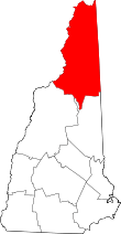
Coordinates: 44°59′00″N 71°06′58″W / 44.98333°N 71.11611°W Atkinson and Gilmanton Academy Grant is a township in Coos County, New Hampshire, United States. It was granted by the state legislature to Gilmanton Academy and Atkinson Academy in equal shares in 1809 and contained about 19,000 acres (77 km2). It was later expanded by annexation of previously ungranted land to the west. The population was 0 at the 2010 census.[1] It is part of the Berlin, NH–VT Micropolitan Statistical Area.
In New Hampshire, locations, grants, townships (which are different from towns), and purchases are unincorporated portions of a county which are not part of any town and have limited self-government (if any, as many are uninhabited).
Geography
According to the United States Census Bureau, the grant has a total area of 19.5 square miles (50.5 km2), of which 19.4 square miles (50.2 km2) is land and 0.1 square miles (0.3 km2) or 0.58%, is covered by water.[2] The highest point is an unnamed ridge that reaches 2,620 feet (800 m) above sea level near the grant's southwestern corner.
The grant boundaries shown in 1874 maps differ from those of 1850s maps by showing a parcel of ungranted "state land" on the western edge of this grant (and north of Dix's Grant), and another "Dartmouth College Grant" to the west of that (later annexed to the eastern edge of Clarksville).
Demographics
| Historical population | |||
|---|---|---|---|
| Census | Pop. | %± | |
| 1910 | 1 | — | |
| 1920 | 20 | 1,900.0% | |
| 1930 | 1 | −95.0% | |
| 1970 | 4 | — | |
| 2000 | 12 | — | |
| Est. 2015 | 0 | [3] | |
As of the census[5] of 2010, there were no people living in the township.
References
- ↑ United States Census Bureau, American FactFinder, 2010 Census figures. Retrieved March 23, 2011.
- ↑ "Geographic Identifiers: 2010 Demographic Profile Data (G001) - Atkinson and Gilmanton Academy grant, New Hampshire". U.S. Census Bureau American Factfinder. Archived from the original on September 11, 2013. Retrieved November 9, 2011.
- ↑ "Annual Estimates of the Resident Population for Incorporated Places: April 1, 2010 to July 1, 2015". Retrieved July 2, 2016.
- ↑ "Census of Population and Housing". Census.gov. Archived from the original on May 11, 2015. Retrieved June 4, 2016.
- ↑ "American FactFinder". United States Census Bureau. Archived from the original on 2013-09-11. Retrieved 2008-01-31.