Errol, New Hampshire
| Errol, New Hampshire | |
|---|---|
| Town | |
|
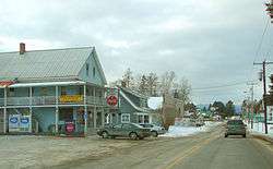
Main Street in Errol | |
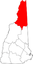
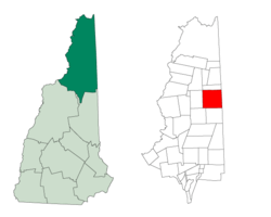 Location in Coos County, New Hampshire | |
| Coordinates: 44°46′53″N 71°08′16″W / 44.78139°N 71.13778°WCoordinates: 44°46′53″N 71°08′16″W / 44.78139°N 71.13778°W | |
| Country | United States |
| State | New Hampshire |
| County | Coos |
| Incorporated | 1836 |
| Area | |
| • Total | 69.8 sq mi (180.7 km2) |
| • Land | 60.6 sq mi (157.0 km2) |
| • Water | 9.1 sq mi (23.6 km2) 13.07% |
| Elevation | 1,227 ft (374 m) |
| Population (2010) | |
| • Total | 291 |
| • Density | 4.2/sq mi (1.6/km2) |
| Time zone | Eastern (UTC-5) |
| • Summer (DST) | Eastern (UTC-4) |
| ZIP code | 03579 |
| Area code(s) | 603 |
| FIPS code | 33-25140 |
| GNIS feature ID | 0873593 |
Errol is a town in Coos County, New Hampshire, United States. The population was 291 at the 2010 census.[1] It is located north of the White Mountains along Route 16 at the intersection of Route 26. It has a municipal airport with a single, unpaved runway (airport code ERR[2]).
Errol is part of the Berlin, NH–VT micropolitan statistical area.
History
Errol was granted by Governor John Wentworth to Timothy Ruggles and others in 1774, the name taken from Scotland's James Hay, 15th Earl of Erroll. In 1789, proprietors of the Errol grant petitioned the General Court that towns between Conway and Errol be required to pay for "a good connecting road." The legislature approved the measure in 1781, mandating what is today Route 16. A winter trade route to Andover, Maine was built in 1804, connecting Errol to Portland by what is now Route 26. The first settlers arrived at Errol in 1806, and by 1820 the population was 36. It was incorporated in 1836.[3]
Although the soil was considered generally poor, it was suitable for hay, oats and potatoes. With vast forests, the town's chief occupation was lumbering. By 1859, when the population was 130, the town had two sawmills, one gristmill and one clapboard machine.[4]
Geography
According to the United States Census Bureau, the town has a total area of 69.8 square miles (181 km2), of which 60.6 square miles (157 km2) is land and 9.1 square miles (24 km2) is water, comprising 13.07% of the town.[5] The Androscoggin River begins in Errol, where the Magalloway River joins the outlet of Umbagog Lake. The town's elevation reaches 2,350 feet (720 m) above sea level atop a bump above Signal Pond near the town's western boundary. Errol lies fully within the Androscoggin River watershed.[6]
The town is served by state routes 16 and 26.
Climate
This climatic region has large seasonal temperature differences, with warm to hot (and often humid) summers and cold (sometimes severely cold) winters. According to the Köppen Climate Classification system, Errol has a humid continental climate, abbreviated "Dfb" on climate maps.[7]
Demographics
| Historical population | |||
|---|---|---|---|
| Census | Pop. | %± | |
| 1810 | 38 | — | |
| 1820 | 26 | −31.6% | |
| 1830 | 82 | 215.4% | |
| 1840 | 104 | 26.8% | |
| 1850 | 138 | 32.7% | |
| 1860 | 178 | 29.0% | |
| 1870 | 178 | 0.0% | |
| 1880 | 161 | −9.6% | |
| 1890 | 178 | 10.6% | |
| 1900 | 305 | 71.3% | |
| 1910 | 211 | −30.8% | |
| 1920 | 241 | 14.2% | |
| 1930 | 293 | 21.6% | |
| 1940 | 235 | −19.8% | |
| 1950 | 224 | −4.7% | |
| 1960 | 220 | −1.8% | |
| 1970 | 199 | −9.5% | |
| 1980 | 313 | 57.3% | |
| 1990 | 292 | −6.7% | |
| 2000 | 298 | 2.1% | |
| 2010 | 291 | −2.3% | |
| Est. 2015 | 273 | [8] | −6.2% |
As of the census[10] of 2000, there were 298 people, 137 households, and 90 families residing in the town. The population density was 4.9 people per square mile (1.9/km²). There were 447 housing units at an average density of 7.3 per square mile (2.8/km²). The racial makeup of the town was 98.66% White, 0.34% Pacific Islander, 0.67% from other races, and 0.34% from two or more races. Hispanic or Latino of any race were 1.01% of the population.
There were 137 households out of which 19.7% had children under the age of 18 living with them, 60.6% were married couples living together, 2.2% had a female householder with no husband present, and 34.3% were non-families. 24.8% of all households were made up of individuals and 9.5% had someone living alone who was 65 years of age or older. The average household size was 2.15 and the average family size was 2.56.
In the town the population was spread out with 16.4% under the age of 18, 3.4% from 18 to 24, 27.5% from 25 to 44, 35.2% from 45 to 64, and 17.4% who were 65 years of age or older. The median age was 47 years. For every 100 females there were 108.4 males. For every 100 females age 18 and over, there were 114.7 males.
The median income for a household in the town was $35,625, and the median income for a family was $47,500. Males had a median income of $37,250 versus $20,250 for females. The per capita income for the town was $22,440. About 9.8% of families and 13.1% of the population were below the poverty line, including 24.2% of those under the age of eighteen and 15.2% of those sixty five or over.
Sites of interest
References
- ↑ United States Census Bureau, American FactFinder, 2010 Census figures. Retrieved March 23, 2011.
- ↑ "Search Results". Abakan IATA search engine. Retrieved 2007-05-24.
- ↑ Androscoggin Timeline
- ↑ Coolidge, Austin J.; John B. Mansfield (1859). A History and Description of New England. Boston, Massachusetts. p. 487.
- ↑ "Geographic Identifiers: 2010 Demographic Profile Data (G001) - Errol town, New Hampshire". U.S. Census Bureau American Factfinder. Retrieved November 8, 2011.
- ↑ Foster, Debra H.; Batorfalvy, Tatianna N.; Medalie, Laura (1995). Water Use in New Hampshire: An Activities Guide for Teachers. U.S. Department of the Interior and U.S. Geological Survey.
- ↑ Climate Summary for Errol, New Hampshire
- ↑ "Annual Estimates of the Resident Population for Incorporated Places: April 1, 2010 to July 1, 2015". Retrieved July 2, 2016.
- ↑ "Census of Population and Housing". Census.gov. Retrieved June 4, 2016.
- ↑ "American FactFinder". United States Census Bureau. Retrieved 2008-01-31.
External links
| Wikimedia Commons has media related to Errol, New Hampshire. |
- Errol Public Library
- Umbagog Snowmobile Association
- Umbagog National Wildlife Refuge
- New Hampshire Economic and Labor Market Information Bureau Profile