Lancaster, New Hampshire
| Lancaster, New Hampshire | ||
|---|---|---|
| Town | ||
|
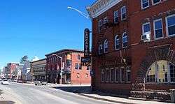
Main Street | ||
| ||
| Motto: "The friendly town in the friendly state" | ||
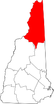
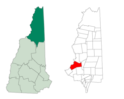 Location in Coos County, New Hampshire | ||
| Coordinates: 44°29′20″N 71°34′09″W / 44.48889°N 71.56917°WCoordinates: 44°29′20″N 71°34′09″W / 44.48889°N 71.56917°W | ||
| Country | United States | |
| State | New Hampshire | |
| County | Coos | |
| Incorporated | 1763 | |
| Government | ||
| • Board of Selectmen |
Leon Rideout, Chair David Stickney Leo Enos | |
| • Town Manager | Edward Samson | |
| Area | ||
| • Total | 50.7 sq mi (131.4 km2) | |
| • Land | 49.8 sq mi (129.1 km2) | |
| • Water | 0.9 sq mi (2.3 km2) 1.73% | |
| Elevation | 863 ft (263 m) | |
| Population (2010) | ||
| • Total | 3,507 | |
| • Density | 70/sq mi (27.2/km2) | |
| Time zone | Eastern (UTC-5) | |
| • Summer (DST) | Eastern (UTC-4) | |
| ZIP code | 03584 | |
| Area code(s) | 603 | |
| FIPS code | 33-40420 | |
| GNIS feature ID | 0873640 | |
| Website |
www | |
Lancaster is a town in Coos County, New Hampshire, United States, on the Connecticut River named after Lancaster, England. As of the 2010 census, the town population was 3,507, the second largest in the county after Berlin.[1] It is the county seat of Coos County and gateway to the Great North Woods Region. Lancaster, which includes the villages of Grange and South Lancaster, is home to Weeks State Park and the Lancaster Fair. Part of the White Mountain National Forest is in the eastern portion. The town is part of the Berlin, NH−VT Micropolitan Statistical Area.
The primary settlement in town, where 1,725 people resided at the 2010 census,[1] is defined as the Lancaster census-designated place (CDP) and is located at the junctions of U.S. Route 3 and U.S. Route 2, along the Israel River.
Lancaster is the site of the "PorcFest" summer camp gathering of the Free State Project.[2][3]
History
Granted as Upper Coos in 1763 by Colonial Governor Benning Wentworth to Captain David Page of Petersham, Massachusetts, the town was settled in 1764 by his son, David Page, Jr. and Emmons Stockwell. It was the first settlement north of Haverhill, 50 miles (80 km) to the south, and originally included land in what is now Vermont. Situated on the northern Connecticut River, the community endured many Indian hostilities. It would be named for Lancaster, Massachusetts, hometown of an early inhabitant. Reverend Joshua Weeks, a grantee of the town, was among the group of explorers who named the mountains of the Presidential Range. Other grantees were Timothy Nash and Benjamin Sawyer, who discovered Crawford Notch in 1771, making a shorter route to Portland, Maine possible.
Many water-powered mills have come and gone, including sawmills, several potato starch mills, one of the largest gristmills in the state, and carriage factories. A granite quarry operated in the Kilkenny Range. With fertile meadows beside the Connecticut River, Lancaster was in 1874 the twelfth most productive agricultural town in the state. An extension of the Boston, Concord & Montreal Railroad shipped products to market, and brought tourists to the grand hotels in the area.
Just south of the village center is Mount Prospect, summer home to Senator John W. Weeks, who sponsored congressional legislation creating White Mountain National Forest. In 1910, he purchased several farms to assemble the 420-acre (170 ha) estate. It is now Weeks State Park, which features a fire lookout and his mansion, open for tours during the summer. A ski rope tow operates on the slope in winter. Many of the White Mountains and Green Mountains can be seen from the stone observation tower built in 1912 atop the 2,059-foot (628 m) summit. The Presidential Range is to the southeast, with the Franconia Range to the south. Mount Weeks, elevation 3,900 ft (1,200 m), is in the Kilkenny Range to the northeast. It is named for the senator, as is the Weeks Medical Center. Weeks Memorial Library, a Beaux Arts landmark listed on the National Register of Historic Places in 2000, was given by John W. Weeks in memory of his father, William Dennis Weeks.
 Lancaster House in 1908
 Main Street c. 1910
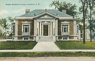 Weeks Library c. 1912
 Main Street c. 1910
Geography
According to the United States Census Bureau, the town has a total area of 50.7 square miles (131 km2), of which 49.8 square miles (129 km2) is land and 0.9 square miles (2.3 km2) is water, comprising 1.73% of the town.[4] The town center, or census-designated place, has a total area of 2.1 sq mi (5.4 km2), of which 2.0 sq mi (5.2 km2) is land and the remainder (1.44%) is water.
Lancaster is drained by the Israel River, and is fully within the Connecticut River watershed.[5] The town also includes Martin Meadow Pond. The town's highest point is located on a western spur of Mount Cabot at 3,290 feet (1,000 m) above sea level.
Climate
| Climate data for Lancaster, New Hampshire | |||||||||||||
|---|---|---|---|---|---|---|---|---|---|---|---|---|---|
| Month | Jan | Feb | Mar | Apr | May | Jun | Jul | Aug | Sep | Oct | Nov | Dec | Year |
| Record high °F (°C) | 62 (17) |
63 (17) |
78 (26) |
90 (32) |
91 (33) |
95 (35) |
95 (35) |
94 (34) |
93 (34) |
82 (28) |
73 (23) |
62 (17) |
95 (35) |
| Average high °F (°C) | 24.5 (−4.2) |
27.9 (−2.3) |
38.2 (3.4) |
51.1 (10.6) |
66.1 (18.9) |
74.1 (23.4) |
78.6 (25.9) |
76.2 (24.6) |
67.6 (19.8) |
55.6 (13.1) |
41.7 (5.4) |
29.4 (−1.4) |
52.58 (11.43) |
| Average low °F (°C) | 1.4 (−17) |
2.1 (−16.6) |
14.7 (−9.6) |
27.6 (−2.4) |
39.4 (4.1) |
48.9 (9.4) |
53.9 (12.2) |
52.1 (11.2) |
43.7 (6.5) |
32.2 (0.1) |
24.4 (−4.2) |
10.2 (−12.1) |
29.22 (−1.53) |
| Record low °F (°C) | −39 (−39) |
−40 (−40) |
−26 (−32) |
−1 (−18) |
18 (−8) |
28 (−2) |
32 (0) |
28 (−2) |
21 (−6) |
8 (−13) |
−9 (−23) |
−36 (−38) |
−40 (−40) |
| Average precipitation inches (mm) | 2.63 (66.8) |
1.81 (46) |
2.35 (59.7) |
2.70 (68.6) |
3.41 (86.6) |
3.99 (101.3) |
3.92 (99.6) |
4.37 (111) |
3.47 (88.1) |
3.21 (81.5) |
3.18 (80.8) |
2.73 (69.3) |
37.77 (959.3) |
| Average snowfall inches (cm) | 18.0 (45.7) |
14.4 (36.6) |
12.2 (31) |
4.3 (10.9) |
trace | 0 (0) |
0 (0) |
0 (0) |
trace | 0.3 (0.8) |
5.6 (14.2) |
15.5 (39.4) |
70.3 (178.6) |
| Source: NOAA [6] | |||||||||||||
Demographics
| Historical population | |||
|---|---|---|---|
| Census | Pop. | %± | |
| 1790 | 161 | — | |
| 1800 | 440 | 173.3% | |
| 1810 | 717 | 63.0% | |
| 1820 | 844 | 17.7% | |
| 1830 | 1,187 | 40.6% | |
| 1840 | 1,316 | 10.9% | |
| 1850 | 1,559 | 18.5% | |
| 1860 | 2,020 | 29.6% | |
| 1870 | 2,248 | 11.3% | |
| 1880 | 2,721 | 21.0% | |
| 1890 | 3,373 | 24.0% | |
| 1900 | 3,190 | −5.4% | |
| 1910 | 3,054 | −4.3% | |
| 1920 | 2,819 | −7.7% | |
| 1930 | 2,887 | 2.4% | |
| 1940 | 3,095 | 7.2% | |
| 1950 | 3,113 | 0.6% | |
| 1960 | 3,138 | 0.8% | |
| 1970 | 3,166 | 0.9% | |
| 1980 | 3,401 | 7.4% | |
| 1990 | 3,522 | 3.6% | |
| 2000 | 3,280 | −6.9% | |
| 2010 | 3,507 | 6.9% | |
| Est. 2015 | 3,351 | [7] | −4.4% |

As of the census of 2010, there were 3,507 people, 1,399 households, and 880 families residing in the town. The population density was 70.4 people per square mile (27.2/km²). There were 1,687 housing units at an average density of 33.9 units/sq mi (13.1 units/km²). The racial makeup of the town was 96.8% White, 0.3% African American, 0.7% Native American, 0.6% Asian, 0.03% Native Hawaiian or Pacific Islander, 0.4% some other race, and 1.1% from two or more races. 1.7% of the population were Hispanic or Latino of any race.[9]
There were 1,399 households, out of which 29.1% had children under the age of 18 living with them, 48.4% were headed by married couples living together, 10.4% had a female householder with no husband present, and 37.1% were non-families. 29.4% of all households were made up of individuals, and 13.1% were someone living alone who was 65 years of age or older. The average household size was 2.35, and the average family size was 2.85.[9]

In the town the population was spread out with 21.9% under the age of 18, 7.3% from 18 to 24, 20.2% from 25 to 44, 31.2% from 45 to 64, and 19.4% who were 65 years of age or older. The median age was 45.4 years. For every 100 females there were 91.8 males. For every 100 females age 18 and over, there were 86.6 males.[9]
For the period 2007-11, the estimated median annual income for a household in the town was $40,455, and the median income for a family was $53,542. Male full-time workers had a median income of $48,438 versus $30,000 for females. The per capita income for the town was $28,245. 13.0% of the population and 10.4% of families were below the poverty line, including 12.7% of people under the age of 18 and 19.2% age 65 or older.[10]
Town center
As of the census of 2010, there were 1,725 people, 705 households, and 422 families residing in the main village, or census-designated place, of Lancaster. The population density was 862.5 people per square mile (331.7/km²). There were 816 housing units at an average density of 408.0 units/sq mi (156.9 units/km²). The racial makeup of the CDP was 96.2% White, 0.5% African American, 0.9% Native American, 0.9% Asian, 0.1% Native Hawaiian or Pacific Islander, 0.2% some other race, and 1.2% from two or more races. 2.5% of the population were Hispanic or Latino of any race.[11]
There were 705 households, out of which 30.8% had children under the age of 18 living with them, 42.4% were headed by married couples living together, 13.6% had a female householder with no husband present, and 40.1% were non-families. 32.1% of all households were made up of individuals, and 14.6% were someone living alone who was 65 years of age or older. The average household size was 2.30, and the average family size was 2.83.[11]
In the CDP the population was spread out with 23.7% under the age of 18, 7.5% from 18 to 24, 21.5% from 25 to 44, 29.6% from 45 to 64, and 17.7% who were 65 years of age or older. The median age was 42.7 years. For every 100 females there were 87.3 males. For every 100 females age 18 and over, there were 83.4 males.[11]
For the period 2007-11, the estimated median annual income for a household was $29,943, and the median income for a family was $52,604. Male full-time workers had a median income of $57,344 versus $24,932 for females. The per capita income for the town was $23,340. 18.5% of the population and 17.7% of families were below the poverty line, including 19.2% of people under the age of 18 and 29.7% age 65 or older.[12]
Transportation
Lancaster is at the intersection of U.S. Route 2 and U.S. Route 3 and is the northern terminus of New Hampshire Route 135, which leads to Dalton and points beyond. A seldom-used railroad track of the Maine Central Railroad skirts the Connecticut River, and a branch at Coos Junction leaves for Jefferson and Waumbek Junction. The Mount Washington Regional Airport is located 11 miles (18 km) away in adjacent Whitefield. As of January 2006, Lancaster is also served by The Tri-Town Bus, a public transportation route connecting with Whitefield and Littleton.
Notable people
- GG Allin, punk singer
- Jacob Benton, US congressman
- Edward E. Cross, Civil War era colonel
- Irving W. Drew, US senator
- Benjamin F. Goss, Wisconsin legislator[13]
- Edward D. Holton, Wisconsin legislator and businessman
- Chester Bradley Jordan, 48th governor of New Hampshire
- Ossian Ray, US congressman
- John W. Weeks, US senator and Secretary of War
- Sinclair Weeks, Secretary of Commerce during Eisenhower Administration
- Jared W. Williams, US senator and congressman; 21st governor of New Hampshire
Sites of interest
- John Wingate Weeks Historic Site & Lodge (1913)
- Lancaster Historical Society Museum
- Wilder-Holton House (1780)
References
- 1 2 United States Census Bureau, American FactFinder, 2010 Census figures. Retrieved March 23, 2011.
- ↑ Hill, Kashmir. "The Free State Project: A Libertarian Testing Ground For Bitcoin, 3D Printers, and Drones". Forbes. Retrieved 17 June 2014.
- ↑ "The Free State Project's 11th Annual Porcupine Freedom Festival". The Free State Project. Retrieved 17 June 2014.
- ↑ "Geographic Identifiers: 2010 Demographic Profile Data (G001) - Lancaster town, New Hampshire". U.S. Census Bureau American Factfinder. Retrieved November 8, 2011.
- ↑ Foster, Debra H.; Batorfalvy, Tatianna N.; Medalie, Laura (1995). Water Use in New Hampshire: An Activities Guide for Teachers. U.S. Department of the Interior and U.S. Geological Survey.
- ↑ "Climatography of the United States No. 20" (PDF). NOAA. Retrieved March 5, 2011.
- ↑ "Annual Estimates of the Resident Population for Incorporated Places: April 1, 2010 to July 1, 2015". Retrieved July 2, 2016.
- ↑ "Census of Population and Housing". Census.gov. Retrieved June 4, 2016.
- 1 2 3 "Profile of General Population and Housing Characteristics: 2010 Demographic Profile Data (DP-1): Lancaster town, Coos County, New Hampshire". U.S. Census Bureau, American Factfinder. Retrieved March 12, 2013.
- ↑ "Selected Economic Characteristics: 2007-2011 American Community Survey 5-Year Estimates (DP03): Lancaster town, Coos County, New Hampshire". U.S. Census Bureau, American Factfinder. Retrieved March 12, 2013.
- 1 2 3 "Profile of General Population and Housing Characteristics: 2010 Demographic Profile Data (DP-1): Lancaster CDP, New Hampshire". U.S. Census Bureau, American Factfinder. Retrieved March 12, 2013.
- ↑ "Selected Economic Characteristics: 2007-2011 American Community Survey 5-Year Estimates (DP03): Lancaster CDP, New Hampshire". U.S. Census Bureau, American Factfinder. Retrieved March 12, 2013.
- ↑ 'Wisconsin Blue Book 1893,' Biographical Sketch of Benjamin Goss, pg. 654
External links
| Wikimedia Commons has media related to Lancaster, New Hampshire. |
- Town of Lancaster official website
- Lancaster Fair
- New Hampshire Economic and Labor Market Information Bureau Profile