Granvin
| Granvin herad | |||
|---|---|---|---|
| Municipality | |||
|
View of the village of Granvin | |||
| |||
 Granvin within Hordaland | |||
| Coordinates: 60°31′37″N 06°43′10″E / 60.52694°N 6.71944°ECoordinates: 60°31′37″N 06°43′10″E / 60.52694°N 6.71944°E | |||
| Country | Norway | ||
| County | Hordaland | ||
| District | Hardanger | ||
| Administrative centre | Eide | ||
| Government | |||
| • Mayor (2011) | Ingebjørg Winjum (V) | ||
| Area | |||
| • Total | 212.46 km2 (82.03 sq mi) | ||
| • Land | 204.94 km2 (79.13 sq mi) | ||
| • Water | 7.52 km2 (2.90 sq mi) | ||
| Area rank | 325 in Norway | ||
| Population (2014) | |||
| • Total | 911 | ||
| • Rank | 412 in Norway | ||
| • Density | 4.4/km2 (11/sq mi) | ||
| • Change (10 years) | -10.8 % | ||
| Demonym(s) | Gravensar[1] | ||
| Time zone | CET (UTC+1) | ||
| • Summer (DST) | CEST (UTC+2) | ||
| ISO 3166 code | NO-1234 | ||
| Official language form | Nynorsk | ||
| Website |
www | ||
|
| |||


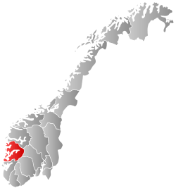
Granvin is a municipality in Hordaland county, Norway. The municipality is located in the traditional district of Hardanger. The administrative centre of Granvin is the village of Eide, which is also called "Granvin". About half of the residents of the municipality live in the municipal centre. The rest live in the rural valley areas surrounding the Granvinsfjorden or the lake Granvinsvatnet in the central part of the municipality.
General information


The parish of Graven (later spelled "Granvin") was established as a municipality on 1 January 1838 (see formannskapsdistrikt). This new municipality was very large and it included two annexes to the parish: Ulvik and Eidfjord. On 1 January 1859, "Ulvik" became the main parish, so that Granvin and Eidfjord became annexes to Ulvik, and the name of municipality was changed accordingly.
On 1 May 1891, the western annex of Granvin (population: 1,331) and the southeastern annex of Eidfjord (population: 1,018) were both separated from Ulvik to become separate municipalities. On 1 January 1964, the Lussand-Kvanndal area of Kinsarvik municipality (population: 72) were transferred to Granvin.[2]
Name
The municipality (originally the parish) is named after the old "Granvin" farm (Old Norse: Grǫnvin), since the first Granvin Church was built there. The first element is grǫn which means "spruce" and the last element is vin which means "meadow" or "pasture". Granvin is one of few parishes in Western Norway with spruce forests.[3]
The name of the parish was spelled as "Graven" before 1858. It was then spelled as "Granvin" from 1858 until 1891. Then the old spelling of "Graven" was used again briefly from 1892-1898. Since 1898 the spelling of "Granvin" has been used.
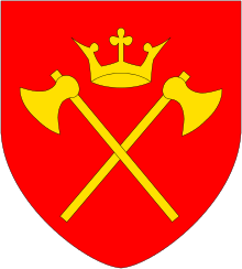
Coat-of-arms
The coat-of-arms is from modern times; they were granted on 13 May 1988. The arms show a hardanger-fiddle (Hardingfele), which is a Norwegian folk instrument. Granvin is situated in the Hardanger region, and has an active folk-music tradition.[4]
Churches
The Church of Norway has one parish (sokn) within the municipality of Granvin. It is part of the Hardanger og Voss deanery in the Diocese of Bjørgvin.
| Parish (Sokn) | Church Name | Location of the Church | Year Built |
|---|---|---|---|
| Granvin | Granvin Church | Granvin | 1726 |
Geography

The municipality is situated along both sides of the Granvinsfjorden (a small arm off of the main Hardangerfjorden) and the valley extending inland from the end of the fjord, in the region of Hardanger. The large lake Granvinsvatnet lies right in the center of the valley, just north of the village of Eide. On both sides of the fjord and valley, there are high mountains. Espeland Falls is located in the Espelandsdalen valley near the border with Ulvik. The Skjervefossen waterfall is also located in Granvin.
Transportation
Norwegian National Road 13 enters Granvin via the Tunsberg Tunnel which runs through the high mountains to the northwest. The highway then runs through Granvin before entering the Vallavik Tunnel which runs through the high mountains to the southeast. The Vallavik Tunnel connects up with the Hardanger Bridge in Ulvik which crosses the Hardangerfjorden. A car ferry service connects Kvanndal (in southwest Granvin) with the villages of Utne and Kinsarvik (in Ullensvang municipality) on the south side of the Hardangerfjord. From 1935 to 1988, Hardanger railway line ran between Granvin and Vossevangen. The line was closed in 1988 and the rails were later removed.
History
| Historical population | ||
|---|---|---|
| Year | Pop. | ±% |
| 1951 | 1,158 | — |
| 1960 | 1,102 | −4.8% |
| 1970 | 1,039 | −5.7% |
| 1980 | 996 | −4.1% |
| 1990 | 1,036 | +4.0% |
| 2000 | 1,044 | +0.8% |
| 2010 | 947 | −9.3% |
| 2014 | 911 | −3.8% |
| Source: Statistics Norway. | ||
In April 1940, during the German invasion of Norway during World War II, there was some fighting between German and Norwegian forces in Granvin. German forces landed in the village of Granvin on 25 April as part of their pincer movement towards the Norwegian military camps at Vossevangen. There was fighting at Skjervefossen for most of that day, until the Norwegian forces retreated late at night to avoid encirclement. Four Norwegian soldiers and at least 30 German soldiers fell in the fighting.[5]
The population of Granvin has been dropping in recent years. In 1951, the population was 1,158. Since then, it has dropped by 21.3% to 911 in 2014. This situation is common in many smaller, rural municipalities in Norway.[6]
Government
All municipalities in Norway, including Granvin, are responsible for primary education (through 10th grade), outpatient health services, senior citizen services, unemployment and other social services, zoning, economic development, and municipal roads. The municipality is governed by a municipal council of elected representatives, which in turn elect a mayor.
Municipal council
The municipal council (Kommunestyre) of Granvin is made up of 13 representatives that are elected to every four years. For 2011–2015, the party breakdown is as follows:[7]
| Party Name | Name in Norwegian | Number of representatives | |
|---|---|---|---|
| Conservative Party | Høgre | 3 | |
| Centre Party | Senterpartiet | 4 | |
| Socialist Left Party | Sosialistisk Venstreparti | 1 | |
| Liberal Party | Venstre | 5 | |
| Total number of members: | 13 | ||
Notable residents
- Lars Jonson Haukaness (1863-1929), an impressionist painter
- Hans Dahl (1849-1937), an artist specializing in landscape paintings
In popular culture
Granvin is a major setting in Moe Cidaly's short story "Summer Episode".[8]
References
- ↑ "Navn på steder og personer: Innbyggjarnamn" (in Norwegian). Språkrådet. Retrieved 2015-12-01.
- ↑ Jukvam, Dag (1999). "Historisk oversikt over endringer i kommune- og fylkesinndelingen" (PDF) (in Norwegian). Statistisk sentralbyrå.
- ↑ Rygh, Oluf (1919). Norske gaardnavne: Nordre Bergenhus amt (in Norwegian) (12 ed.). Kristiania, Norge: W. C. Fabritius & sønners bogtrikkeri. pp. 484, 486.
- ↑ "Civic heraldry of Norway - Norske Kommunevåpen". Heraldry of the World. Retrieved 2014-05-19.
- ↑ Hansteen, Wilhelm (1971). Operasjonene til lands på Vestlandet og i Hallingdal og Numedal (in Norwegian). Oslo. pp. 170–183.
- ↑ "Population changes in municipalities 1951-2014. Granvin." (in Norwegian). Statistics Norway. Retrieved 2014-05-22.
- ↑ "Members of the local councils, by party/electoral lists and municipality" (in Norwegian). Statistics Norway. 2011.
- ↑ "Summer Episode". moecidaly.com. 2016.
| Wikimedia Commons has media related to Granvin. |
External links
 The dictionary definition of Granvin at Wiktionary
 Hordaland travel guide from Wikivoyage
- Hardanger travel guide from Wikivoyage