Voss
| Voss kommune | |||
|---|---|---|---|
| Municipality | |||
|
Voss in March 2005 | |||
| |||
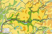
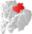 Voss within Hordaland | |||
| Coordinates: 60°42′09″N 06°25′23″E / 60.70250°N 6.42306°ECoordinates: 60°42′09″N 06°25′23″E / 60.70250°N 6.42306°E | |||
| Country | Norway | ||
| County | Hordaland | ||
| District | Voss | ||
| Administrative centre | Vossevangen | ||
| Government | |||
| • Mayor (2011) | Hans-Erik Ringkjøb (Ap) | ||
| Area | |||
| • Total | 1,805.81 km2 (697.23 sq mi) | ||
| • Land | 1,731.97 km2 (668.72 sq mi) | ||
| • Water | 73.84 km2 (28.51 sq mi) | ||
| Area rank | 38 in Norway | ||
| Population (2013) | |||
| • Total | 14,168 | ||
| • Rank | 82 in Norway | ||
| • Density | 8.2/km2 (21/sq mi) | ||
| • Change (10 years) | 2.9 % | ||
| Demonym(s) |
Vossing Voss (male) Vosse (female)[1] | ||
| Time zone | CET (UTC+1) | ||
| • Summer (DST) | CEST (UTC+2) | ||
| ISO 3166 code | NO-1235 | ||
| Official language form | Nynorsk | ||
| Website |
www | ||
|
| |||

![]() Voss is a municipality and a traditional district in Hordaland county, Norway. The administrative center of the municipality is the village of Vossevangen. Other villages include Bolstadøyri, Borstrondi, Evanger, Kvitheim, Mjølfjell, Oppheim, Stalheim, and Vinje.
Voss is a municipality and a traditional district in Hordaland county, Norway. The administrative center of the municipality is the village of Vossevangen. Other villages include Bolstadøyri, Borstrondi, Evanger, Kvitheim, Mjølfjell, Oppheim, Stalheim, and Vinje.
Municipal history
Voss has been established as a municipality on 1 January 1838 (see formannskapsdistrikt). On 1 January 1867, a small area in northern Voss (population: 28) was transferred to the municipality of Hosanger. On 1 January 1868, the northern district of the municipality (population: 2,009) was separated to form the new municipality of Vossestrand. This left 7,592 residents in Voss. On 21 August 1868, an unpopulated area of northern Voss was transferred to Vossestrand. Then, on 1 January 1885, the western district of Voss (population: 2,045) was separated to form the new municipality of Evanger. This left Voss with 5,403 residents.
On 1 January 1964, a major municipal merger took place as a result of the Schei committee. The municipality of Voss (population: 10,575), the municipality of Vossestrand (population: 1,573), and most of the municipality of Evanger (population: 1,075) were all merged into a new, larger municipality of Voss. (The rest of Evanger was merged into the new municipality of Vaksdal.)[2]
Name
The Old Norse form of the name was Vǫrs, and this might have been the old name of lake Vangsvatnet. If this is the case, the name probably is derived from the word vǫrr which means "wave" or "sea". (-s is a common suffix in old Norwegian place names.)[3]
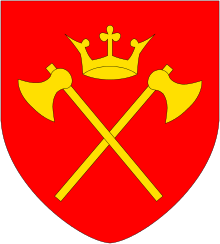
Coat-of-arms
The coat-of-arms is from modern times. They were granted on 8 July 1977. They show a gray deer on a red background. The arms are based on the seal of Peter who was the owner of the farm Finne in Voss, which was one of the largest farms in Western Norway during the Middle Ages. He used a silver deer on a red background as his personal coat-of-arms in 1303. His son also used a deer on his seals as did most of their relatives until 1460. The shape and position of the deer changed between the different persons, but it always was the main figure.[4]
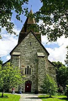
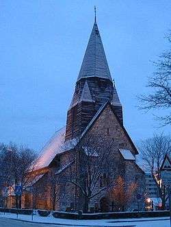
Churches
The Church of Norway has six parishes (sokn) within the municipality of Voss. It is part of the Hardanger og Voss deanery in the Diocese of Bjørgvin.
| Parish (sokn) | Church name | Location | Year built |
|---|---|---|---|
| Evanger | Evanger Church | Evanger | 1851 |
| Oppheim | Oppheim Church | Oppheim | 1871 |
| Raundalen | Raundalen Church | Raundalen | 1921 |
| Vinje | Vinje Church | Vinje | 1871 |
| Voss | Voss Church | Vossevangen | 1277 |
History
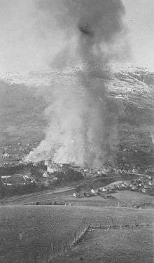
After the German invasion of Norway on 9 April 1940, Voss was the main point of mobilisation for the Norwegian Army in the west, since the city of Bergen had already fallen on 9 April. From Bergen and from the Hardangerfjord, the Nazis were met with stiff Norwegian resistance. In Hardanger, some of the Germans climbed up the mountains from Ålvik while the rest went through Granvin. To break down this resistance, the town of Voss was bombed by the Luftwaffe on 23 and April 24, and the surrounding countryside on April 25. Nine people lost their lives in the bombing, which completely destroyed the old wood-built town centre. On 26 April, the German forces entered the town, which remained occupied until 8 May 1945.
| Historical population | ||
|---|---|---|
| Year | Pop. | ±% |
| 1951 | 9,433 | — |
| 1960 | 10,275 | +8.9% |
| 1970 | 13,765 | +34.0% |
| 1980 | 14,163 | +2.9% |
| 1990 | 14,035 | −0.9% |
| 2000 | 13,726 | −2.2% |
| 2010 | 13,902 | +1.3% |
| 2014 | 14,168 | +1.9% |
| Source: Statistics Norway. | ||
In 1964, the municipality was enlarged with the incorporation of neighbouring municipalities of Vossestrand and Evanger, which had up until then been separate municipalities within the traditional district also known as Voss.
Government
All municipalities in Norway, including Voss, are responsible for primary education (through 10th grade), outpatient health services, senior citizen services, unemployment and other social services, zoning, economic development, and municipal roads. The municipality is governed by a municipal council of elected representatives, which in turn elect a mayor.
Municipal council
The municipal council (Kommunestyre) of Voss is made up of 43 representatives that are elected to every four years. For 2011–2015, the party breakdown is as follows:[5]
| Party Name | Name in Norwegian | Number of representatives | |
|---|---|---|---|
| Labour Party | Arbeiderpartiet | 12 | |
| Progress Party | Framstegspartiet | 4 | |
| Conservative Party | Høgre | 8 | |
| Christian Democratic Party | Kristelig Folkeparti | 2 | |
| Red Party | Raudt | 1 | |
| Centre Party | Senterpartiet | 8 | |
| Socialist Left Party | Sosialistisk Venstreparti | 3 | |
| Liberal Party | Venstre | 5 | |
| Total number of members: | 43 | ||
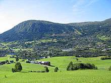
Geography & Climate
Voss is situated at the innermost part of the Bolstadsfjorden and it includes the valleys that head inland from there. The municipality includes several large lakes: Evangervatnet, Hamlagrøvatnet, Lønavatnet, Oppheimsvatnet, Torfinnsvatnet, and Vangsvatnet. In the north, Voss municipality reaches to the Nærøydalen valley which leads up to the famous Nærøyfjorden. The Stalheimsfossen waterfall near the village of Stalheim sits just above that valley. The Raundalen valley in the east is the main route for the Bergansbanen railway line which connects eastern and western Norway.
| Climate data for Voss, Norway | |||||||||||||
|---|---|---|---|---|---|---|---|---|---|---|---|---|---|
| Month | Jan | Feb | Mar | Apr | May | Jun | Jul | Aug | Sep | Oct | Nov | Dec | Year |
| Average high °C (°F) | −0.7 (30.7) |
0.3 (32.5) |
4.5 (40.1) |
8.7 (47.7) |
15.0 (59) |
19.0 (66.2) |
19.8 (67.6) |
19.0 (66.2) |
13.9 (57) |
9.3 (48.7) |
3.2 (37.8) |
0.6 (33.1) |
9.38 (48.88) |
| Daily mean °C (°F) | −4.5 (23.9) |
−3.8 (25.2) |
0.2 (32.4) |
3.9 (39) |
9.3 (48.7) |
13.2 (55.8) |
14.2 (57.6) |
13.4 (56.1) |
9.4 (48.9) |
5.9 (42.6) |
0.3 (32.5) |
−3.0 (26.6) |
4.87 (40.78) |
| Average low °C (°F) | −7.0 (19.4) |
−7.2 (19) |
−3.4 (25.9) |
−0.4 (31.3) |
4.0 (39.2) |
7.9 (46.2) |
9.8 (49.6) |
9.2 (48.6) |
6.0 (42.8) |
2.8 (37) |
−2.1 (28.2) |
−5.5 (22.1) |
1.18 (34.11) |
| Average precipitation mm (inches) | 123 (4.84) |
89 (3.5) |
97 (3.82) |
49 (1.93) |
56 (2.2) |
71 (2.8) |
78 (3.07) |
95 (3.74) |
160 (6.3) |
161 (6.34) |
150 (5.91) |
151 (5.94) |
1,280 (50.39) |
| Average precipitation days | 15.5 | 10.0 | 11.5 | 9.1 | 10.1 | 10.7 | 12.1 | 13.0 | 16.5 | 17.5 | 16.1 | 16.4 | 158.5 |
| Source: Weatherbase.com[6] | |||||||||||||
Tourism
Voss sits in a location surrounded by snow-capped mountains, forests, lakes and fast flowing white water rivers. This has led to its development as a notable center of skiing, water sports, skydiving, paragliding and other adventure sports. The area hosts the Ekstremsportveko[7] (Extreme Sports Week) every year in the last week of June, which is regarded as the world's premier extreme sports festival. Bømoen, the local airstrip, is home to Skydive Voss, one of the largest dropzones in Norway, as well as a gliding club. The rivers provide various levels of white water, attracting kayaking, rafting and river boarding. Kite surfing and Para-bungee may be seen on lake Vangsvatnet. The ski area, to the north of the town, is accessible via a cable car, Hangursbanen from the town. There is also chair lift access from Bavallen, a short distance to the northeast of Voss.
The town's proximity to the Sognefjord and its position between Bergen and Flåm on the scenic railway have made it popular with tourists. One of the sights on the road to Flåm is the waterfall Tvindefossen.
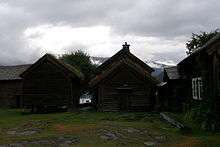
The Voss Museum displays several old farmsteads, including the larger than life stone statue of Lars O. Kindem. Next to the open-air part, there is a museum building with over 20,000 items from traditional farm life.
Birdlife
Voss has a wide range of habitats, everything from high barren mountains to rich fertile valleys. The large areas of coniferous forests provide food and shelter for a whole host of species, while the many wetland areas are regarded as some of the most interesting birding habitats in the county. There is a bird reserve at Lønaøyane with marked paths and a tower hide. Over 155 species have been seen at this locality. Many are common Scandinavian species, but the area has also produced the unexpected like the great egret, European hobby, and woodlark.
Notable residents
Artists
- Brynjulf Bergslien, painter
- Lars Fletre, painter
- Knud Bergslien, painter
Athletes
- Trond Egil Soltvedt, Former Southampton and Norwegian international footballer
- Gisle Fenne, World Cup silver medalist in biathlon
- Odd Lirhus, World Cup winner in biathlon
- Gro Marit Istad Kristiansen, World champion in biathlon
- Astrid Lødemel, World Cup silver medalist in alpine skiing
- Jori Mørkve, Biathlon, relay bronze winner in the World Championships in Antholz
- Kristian Ystaas, Footballer
- Jon Istad, World Championship gold in 1966 biathlon shooter + king
- Sjur Røthe, Cross-country
Olympic champions
Voss is a winter sports center and has in recent times been the home of many world-class athletes in several winter sports, most prominently biathlon, but also alpine skiing, nordic skiing and freestyle skiing. In all, athletes from Voss have won 6 gold medals, 5 silver medals and 7 bronze medals at winter Olympic games. Athletes from Voss have been present, representing Norway, at every winter Olympic games except one since 1948 Winter Olympics, the exception being 1972.
- Jan Einar Thorsen, 1994 Winter Olympics, bronze medal winner in downhill
- Eirik Kvalfoss, 1984 Winter Olympics (biathlon, sprint)
- Kristen Skjeldal, 1992 Winter Olympics (cross-country skiing, relay)
- Kari Traa, 2002 Winter Olympics (freestyle skiing, moguls)
- Egil Gjelland, 2002 Winter Olympics (biathlon, relay)
- Lars Bystøl, 2006 Winter Olympics (ski jumping, K90)
- Hilde Synnøve Lid, 1994 Winter Olympics bronze medal winner in freestyle
Politicians
- Lars Leiro - former Transport Minister
- Jon Lilletun (1945-2006) - Minister in the Ministry of Education and Research from 1997-2001 (KrF)
Others
- Gunnstein Akselberg, linguist
- Ingvild Bryn, news anchor for NRK
- Rune Hauge, football agent
- Arne Hjeltnes, presenter for TV2
- Guri Solberg, presenter for TV2
- Lars Tvinde, actor
Norwegian-Americans
Like the rest of Western Norway, Voss saw large-scale emigration, particularly to the United States, in the 19th and early 20th centuries.
- John Anderson, founder and publisher Skandinaven
- Lars Fletre, sculptor
- Canute R. Matson, Sheriff of Cook County, Illinois
- Knute Nelson, US Senator
- Eli Pederson, Wisconsin State Assemblyman
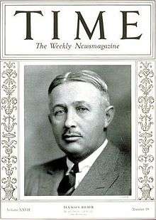
- Torkild Rieber, chairman of Texaco
- Knute Rockne, American football player and coach, who is commemorated by a memorial in Vossevangen
- Aad J. Vinje, Chief Justice of the Wisconsin Supreme Court
- Lars G. Kindem, President, United States Ski Association and educator
References
- ↑ "Navn på steder og personer: Innbyggjarnamn" (in Norwegian). Språkrådet. Retrieved 2015-12-01.
- ↑ Jukvam, Dag (1999). "Historisk oversikt over endringer i kommune- og fylkesinndelingen" (PDF) (in Norwegian). Statistisk sentralbyrå.
- ↑ Rygh, Oluf (1919). Norske gaardnavne: Nordre Bergenhus amt (in Norwegian) (12 ed.). Kristiania, Norge: W. C. Fabritius & sønners bogtrikkeri. p. 527.
- ↑ "Civic heraldry of Norway - Norske Kommunevåpen". Heraldry of the World. Retrieved 2014-05-19.
- ↑ "Members of the local councils, by party/electoral lists and municipality" (in Norwegian). Statistics Norway. 2011.
- ↑ http://www.weatherbase.com/weather/weather.php3?s=560525
- ↑ Ekstremsportveko
External links
| Wikimedia Commons has media related to Voss. |
| Wikivoyage has a travel guide for Voss. |
- Vossestrand (Norwegian)
- The Norwegian Birding Route