Austrheim
| Austrheim kommune | |||
|---|---|---|---|
| Municipality | |||
 | |||
| |||
 Austrheim within Hordaland | |||
| Coordinates: 60°46′16″N 04°55′34″E / 60.77111°N 4.92611°ECoordinates: 60°46′16″N 04°55′34″E / 60.77111°N 4.92611°E | |||
| Country | Norway | ||
| County | Hordaland | ||
| District | Nordhordland | ||
| Administrative centre | Årås | ||
| Government | |||
| • Mayor (2011) | Per Lerøy (Ap) | ||
| Area | |||
| • Total | 57.55 km2 (22.22 sq mi) | ||
| • Land | 56.82 km2 (21.94 sq mi) | ||
| • Water | 0.73 km2 (0.28 sq mi) | ||
| Area rank | 420 in Norway | ||
| Population (2014) | |||
| • Total | 2,833 | ||
| • Rank | 279 in Norway | ||
| • Density | 49.9/km2 (129/sq mi) | ||
| • Change (10 years) | 11.8 % | ||
| Demonym(s) | Austrheiming[1] | ||
| Time zone | CET (UTC+1) | ||
| • Summer (DST) | CEST (UTC+2) | ||
| ISO 3166 code | NO-1264 | ||
| Official language form | Nynorsk | ||
| Website |
www | ||
|
| |||

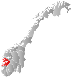
Austrheim is a municipality in the Nordhordland region of Hordaland county, Norway. The administrative centre of the municipality is the village of Årås. Other villages in the municipality include Austrheim and Kaland. The Mongstad industrial area lies along the border of Austrheim and neighboring Lindås municipality. The westernmost point of mainland Norway lies in the municipality at Vardetangen.
General information
.jpg)

Historically, Austrheim was a part of the large municipality of Lindås. On 1 January 1910, the northwestern district of Lindås (population: 2,518) was separated from Lindås to form the new municipality of Austrheim. On 1 January 1947, all of the islands located west of the Fedjefjorden (population: 920) was separated to form the new municipality of Fedje. On 1 January 1964, the Straume area on the island of Radøy (population: 56) was transferred from Austrheim to the new municipality of Radøy.[2]
Name
The municipality (originally the parish) is named after the old Austrheim farm (Old Norse: Austrheimr), since the first church (Austrheim Church) was built there. The first element is austr which means "east" and the last element is heimr which means "homestead" or "farm". Until 1889, the name was written Østereim. After that the spelling was Austreim, and most recently it is spelled Austrheim.[3]
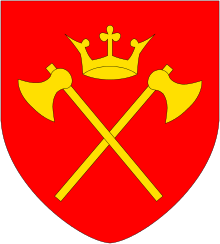
Coat-of-arms
The coat-of-arms is from modern times; they were granted on 17 February 1989. It shows three silver bows (as in the shape of a rainbow) on a blue background. The three bows represent the many bridges in the island municipality.[4]
Churches
The Church of Norway has one parish (sokn) within the municipality of Austrheim. It is part of the Nordhordland deanery in the Diocese of Bjørgvin.
| Parish (Sokn) | Church Name | Location of the Church | Year Built |
|---|---|---|---|
| Austrheim | Austrheim Church | Austrheim | 1865 |
Government
All municipalities in Norway, including Austrheim, are responsible for primary education (through 10th grade), outpatient health services, senior citizen services, unemployment and other social services, zoning, economic development, and municipal roads. The municipality is governed by a municipal council of elected representatives, which in turn elect a mayor.
Municipal council
The municipal council (Kommunestyre) of Austrheim is made up of 17 representatives that are elected to every four years. For 2011–2015, the party breakdown is as follows:[5]
| Party Name | Name in Norwegian | Number of representatives | |
|---|---|---|---|
| Labour Party | Arbeiderpartiet | 6 | |
| Progress Party | Framstegspartiet | 1 | |
| Conservative Party | Høgre | 5 | |
| Christian Democratic Party | Kristelig Folkeparti | 2 | |
| Centre Party | Senterpartiet | 1 | |
| Liberal Party | Venstre | 2 | |
| Total number of members: | 17 | ||
Economy
The Mongstad industrial complex lies on the border of Austrheim and Lindås. It is the largest oil port and refinery in Norway, is responsible for about 70% of all wet bulk. Many residents of Austrheim work at the facility.
| Historical population | ||
|---|---|---|
| Year | Pop. | ±% |
| 1951 | 2,390 | — |
| 1960 | 2,216 | −7.3% |
| 1970 | 1,880 | −15.2% |
| 1980 | 2,549 | +35.6% |
| 1990 | 2,684 | +5.3% |
| 2000 | 2,527 | −5.8% |
| 2010 | 2,738 | +8.3% |
| 2014 | 2,833 | +3.5% |
| Source: Statistics Norway. | ||
Geography
Austrheim is an island municipality in the Nordhordland region of Hordaland county. It is located south of the Fensfjorden, east of the Fedjefjorden, north of the island of Radøy, and west of the Lindås peninsula. The municipality includes the far northwestern tip of the peninsula as well as many islands. The largest island (by far) is the island of Fosnøyna, where the municipal centre is located.
Gulen municipality is located to the north (across the fjord), Fedje municipality is located on islands to the west, Radøy municipality lies on an island to the southwest, and Lindås municipality lies to the southeast.
Famous people
- Karsten Solheim, golf equipment manufacturer (1911–2000) (emigrated to the United States as a child)
- Roger Helland Football player (1973- )
- Haakon Austrheim, geology professor
References
- ↑ "Navn på steder og personer: Innbyggjarnamn" (in Norwegian). Språkrådet. Retrieved 2015-12-01.
- ↑ Jukvam, Dag (1999). "Historisk oversikt over endringer i kommune- og fylkesinndelingen" (PDF) (in Norwegian). Statistisk sentralbyrå.
- ↑ Rygh, Oluf (1919). Norske gaardnavne: Nordre Bergenhus amt (in Norwegian) (12 ed.). Kristiania, Norge: W. C. Fabritius & sønners bogtrikkeri. pp. 420, 423.
- ↑ "Civic heraldry of Norway - Norske Kommunevåpen". Heraldry of the World. Retrieved 2014-04-02.
- ↑ "Members of the local councils, by party/electoral lists and municipality" (in Norwegian). Statistics Norway. 2011.
External links
 Media related to Austrheim at Wikimedia Commons
 The dictionary definition of Austrheim at Wiktionary
- Municipal fact sheet from Statistics Norway
 Hordaland travel guide from Wikivoyage