Ullensvang
| Ullensvang herad | |||
|---|---|---|---|
| Municipality | |||
 | |||
| |||
 Ullensvang within Hordaland | |||
| Coordinates: 60°18′42″N 06°48′53″E / 60.31167°N 6.81472°ECoordinates: 60°18′42″N 06°48′53″E / 60.31167°N 6.81472°E | |||
| Country | Norway | ||
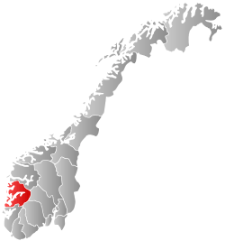
| County | Hordaland | ||
| District | Hardanger | ||
| Administrative centre | Kinsarvik | ||
| Government | |||
| • Mayor (2003) | Solfrid Borge (Sp) | ||
| Area | |||
| • Total | 1,398.52 km2 (539.97 sq mi) | ||
| • Land | 1,287.13 km2 (496.96 sq mi) | ||
| • Water | 111.39 km2 (43.01 sq mi) | ||
| Area rank | 61 in Norway | ||
| Population (2014) | |||
| • Total | 3,369 | ||
| • Rank | 254 in Norway | ||
| • Density | 2.6/km2 (7/sq mi) | ||
| • Change (10 years) | -4.1 % | ||
| Demonym(s) |
Sørfjøre Sørfjording[1] | ||
| Time zone | CET (UTC+1) | ||
| • Summer (DST) | CEST (UTC+2) | ||
| ISO 3166 code | NO-1231 | ||
| Official language form | Nynorsk | ||
| Website |
www | ||
|
| |||

Ullensvang is a municipality in Hordaland county, Norway. It is located in the traditional district of Hardanger. The administrative centre is the village of Kinsarvik. Other villages in the municipality include Lofthus, Utne, Vikebygd, and Alsåker. There are 3,369 inhabitants as of 1 January 2014. The number of inhabitants has shown a decrease of almost 700 people since 1980. This development can be seen in light of the general depopulation of rural Norway.
The main inhabited part of Ullensvang municipality lies just to the west of Hardangervidda National Park, which covers most of the Hardangervidda plateau, Europe's largest mountain plateau. Most inhabitants live in the narrow coastal mountainsides and valleys along the Hardangerfjorden and Sørfjorden. The largest urban areas in Ullensvang are Kinsarvik and Lofthus.
The Norwegian National Road 13 is one of the main roads through the municipality, and it crosses the Hardangerfjorden via the Hardanger Bridge in the far northern part of the municipality.
General information


Name
The municipality (originally the parish) is named after the old Ullensvang farm (Old Norse: Ullinsvangr), since Ullensvang Church was built there. The first element is the genitive case of the name of the Norse god Ullin (sideform of Ullr). The last element is vangr which means "field" or "meadow".[2]
Coat-of-arms
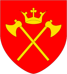
The coat-of-arms was granted on 8 November 1979. The arms are red with a horizontal gold stripe across the middle, with three gold fleur-de-lis designs (two above the stripe, one below). The municipal arms are derived from the arms of nobleman from the area, Sigurd Brynjulvsson Galte, and they can be seen on his gravestone dating back to 1302 at the local church. As it is the oldest gravestone in the church, the arms were well known in the village, hence the choice for the arms of this knight as municipal arms.[3]
Churches
The Church of Norway has three parishes (sokn) within the municipality of Ullensvang. It is part of the Hardanger og Voss deanery in the Diocese of Bjørgvin.
| Parish (Sokn) | Church Name | Location of the Church | Year Built |
|---|---|---|---|
| Kinsarvik | Kinsarvik Church | Kinsarvik | 1150 |
| Ullensvang | Ullensvang Church | Lofthus | 1250 |
| Utne | Utne Church | Utne | 1895 |
History

| Historical population | ||
|---|---|---|
| Year | Pop. | ±% |
| 1951 | 2,294 | — |
| 1960 | 2,420 | +5.5% |
| 1970 | 4,848 | +100.3% |
| 1980 | 4,041 | −16.6% |
| 1990 | 3,988 | −1.3% |
| 2000 | 3,562 | −10.7% |
| 2010 | 3,382 | −5.1% |
| 2014 | 3,369 | −0.4% |
| Source: Statistics Norway. Note: there were major border changes to the municipality in 1964 and 1977 causing large changes in the population. | ||
On 1 January 1838, the large parish of Kinsarvik was established as a municipality (see formannskapsdistrikt). The large parish was made up of the main parish and the annex of Ullensvang. On 1 January 1869, Ullensvang became the main parish and Kinsarvik became an annex to Ullensvang. At this time the municipality changed its name to Ullensvang. On 1 January 1882, a small area of Ullensvang (population: 22) was transferred to the neighboring municipality of Vikør. On 1 July 1913, the municipality of Ullensvang was divided into three parts: the northwestern part became Kinsarvik, the southern part became Odda, and the rest remained as Ullensvang, albeit much smaller. This left Ullensvang with 1,941 residents.
On 1 January 1964, a major municipal merger took place as a result of the recommendations by the Schei Committee. The following areas were merged into one large municipality: all of Ullensvang, all of Eidfjord, and most of Kinsarvik (except for the Lussand-Kvanndal area which went to Granvin). The new municipality was named Ullensvang. On 1 January 1965, the Åsgrenda area of Kvam municipality (population: 61) was transferred to Ullensvang. This new, large municipality of Ullensvang that was created in 1964 was not long-lived. On 1 January 1977, the area that once was Eidfjord became its own municipality once again. This left Ullensvang with 3,937 residents.[4]
Geography
The municipality of Ullensvang is located on the shores of the Hardangerfjorden and the Sørfjorden and it stretches all the way up to the Folgefonna glacier inside Folgefonna National Park on the Folgefonna peninsula in the western part of the municipality. It continues up to the vast Hardangervidda plateau in the east, including part of the Hardangervidda National Park. The lakes Kvensjøen and Veivatnet as well as the mountain Hårteigen are all located in Ullensvang on the plateau.[5]
Government

All municipalities in Norway, including Ullensvang, are responsible for primary education (through 10th grade), outpatient health services, senior citizen services, unemployment and other social services, zoning, economic development, and municipal roads. The municipality is governed by a municipal council of elected representatives, which in turn elect a mayor.
Municipal council
The municipal council (Kommunestyre) of Ullensvang is made up of 21 representatives that are elected to every four years. For 2011–2015, the party breakdown is as follows:[6]
| Party Name | Name in Norwegian | Number of representatives | |
|---|---|---|---|
| Labour Party | Arbeiderpartiet | 2 | |
| Conservative Party | Høgre | 4 | |
| Christian Democratic Party | Kristelig Folkeparti | 1 | |
| Centre Party | Senterpartiet | 8 | |
| Socialist Left Party | Sosialistisk Venstreparti | 1 | |
| Liberal Party | Venstre | 5 | |
| Total number of members: | 21 | ||
Attractions

Ullensvang is Norway's biggest supplier of fruit, especially sweet cherries and apples. Every summer a cherry festival is held at Lofthus, where the Norwegian championship of cherry stone spitting is held. The record is 14.24 metres (46.7 ft) by S. Kleivkaas. Each May, a musical festival is held at Ullensvang Hotel (built in 1846), when musicians from all of Norway come to the village. The famous composer Edvard Grieg spent many summers at Lofthus, and the festival is held in his honor. During the summer, the population is doubled due to tourism. Attractions in addition to the previous mentioned, are the medieval Ullensvang Church at Lofthus (built around 1250) and Kinsarvik Church (built around 1150), several waterfalls such as the Skrikjofossen, the flowering season in May, and museums at Aga, Utne, and Skredhaugen.
References
- ↑ "Navn på steder og personer: Innbyggjarnamn" (in Norwegian). Språkrådet. Retrieved 2015-12-01.
- ↑ Rygh, Oluf (1919). Norske gaardnavne: Nordre Bergenhus amt (in Norwegian) (12 ed.). Kristiania, Norge: W. C. Fabritius & sønners bogtrikkeri. p. 449.
- ↑ "Civic heraldry of Norway - Norske Kommunevåpen". Heraldry of the World. Retrieved 2014-06-05.
- ↑ Jukvam, Dag (1999). "Historisk oversikt over endringer i kommune- og fylkesinndelingen" (PDF) (in Norwegian). Statistisk sentralbyrå.
- ↑ Store norske leksikon. "Ullensvang" (in Norwegian). Retrieved 2014-06-05.
- ↑ "Members of the local councils, by party/electoral lists and municipality" (in Norwegian). Statistics Norway. 2011.