Vaksdal
| Vaksdal kommune | |||
|---|---|---|---|
| Municipality | |||
 | |||
| |||
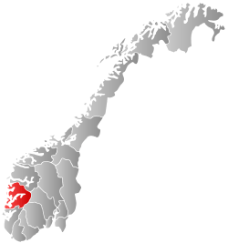
 Vaksdal within Hordaland | |||
| Coordinates: 60°36′25″N 05°48′58″E / 60.60694°N 5.81611°ECoordinates: 60°36′25″N 05°48′58″E / 60.60694°N 5.81611°E | |||
| Country | Norway | ||
| County | Hordaland | ||
| District | Nordhordland | ||
| Administrative centre | Dalekvam | ||
| Government | |||
| • Mayor (2007) | Eirik Haga (Ap) | ||
| Area | |||
| • Total | 715.34 km2 (276.19 sq mi) | ||
| • Land | 683.42 km2 (263.87 sq mi) | ||
| • Water | 31.92 km2 (12.32 sq mi) | ||
| Area rank | 154 in Norway | ||
| Population (2014) | |||
| • Total | 4,140 | ||
| • Rank | 230 in Norway | ||
| • Density | 6.1/km2 (16/sq mi) | ||
| • Change (10 years) | -0.8 % | ||
| Demonym(s) |
Vaksdaling (Vaksdøling)[1] | ||
| Time zone | CET (UTC+1) | ||
| • Summer (DST) | CEST (UTC+2) | ||
| ISO 3166 code | NO-1251 | ||
| Official language form | Nynorsk | ||
| Website |
www | ||
|
| |||

![]() Vaksdal is a municipality in the county of Hordaland, Norway. It is located in the traditional district of Nordhordland. The administrative centre is the village of Dalekvam. Other villages in Vaksdal include Dalegarden, Flatkvål, Helle, Nesheim, Stamneshella, Stanghelle, and Vaksdal.
Vaksdal is a municipality in the county of Hordaland, Norway. It is located in the traditional district of Nordhordland. The administrative centre is the village of Dalekvam. Other villages in Vaksdal include Dalegarden, Flatkvål, Helle, Nesheim, Stamneshella, Stanghelle, and Vaksdal.
General information
The municipality of Vaksdal was created on 1 January 1964 after a major municipal restructuring after the Schei Committee's recommendations. Vaksdal was formed from the following places:[2]
- All of Bruvik municipality, except for the Bruvikbygda area on Osterøy island (population: 5,264)
- The Bergsdalen and Eksingedalen valleys from the municipality of Evanger (population: 251)
- The rest of the Eksingedalen valley that was located in the municipality of Modalen (population: 151)
Name
The municipality was named after the village of Vaksdal, one of the main villages in the municipality. The Old Norse form of the name was probably Vágsdalr. The first element is the genitive case of vágr which means "bay" and the last element is dalr which means "valley" or "dale". Alternately, the first part of the name could be derived from a local river name spelled Vaxa or Veksa which would mean the valley of the river Vaxa/Veksa.[3]
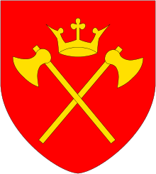
Coat-of-arms
The coat-of-arms is from modern times; they were granted on 16 November 1990. It shows three black shuttles for weaving on a yellow background. The shuttles were chosen to represent the textile industry of the municipality. The Dale of Norway company is based here and it is an international company renowned for its wool sweaters.[4]
Churches
The Church of Norway has six parishes (sokn) within the municipality of Vaksdal. It is part of the Hardanger og Voss deanery in the Diocese of Bjørgvin.
| Parish (Sokn) | Church Name | Location of the Church | Year Built |
|---|---|---|---|
| Bergsdalen | Bergsdalen Church | Bergsdalen | 1955 |
| Dale | Dale Church | Dalekvam | 1956 |
| Eksingedal | Eksingedal Church | Flatkvål | 1883 |
| Nesheim | Nesheim Church | Nesheim | 1908 |
| Stamnes | Stamnes Church | Stamneshella | 1861 |
| Vaksdal | Vaksdal Church | Vaksdal | 1933 |
Geography

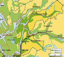
The municipality is mountainous, and stretches along both sides of the Veafjorden with adjacent valleys. It includes part of the island Osterøy. The Kallestadsundet Bridge connects the mainland of Vaksdal to the island of Osterøy. In the north, it includes the valleys of Eksingedalen and Bergsdalen, with its borders extending into the mountains, bordering Sogn og Fjordane county in the north. Major lakes in the municipality include Askjelldalsvatnet and Skjerjavatnet.
The main centers of population are Dale (pop. 1174), Vaksdal (pop. 957), and Stanghelle (pop. 767).[5] Dale and Vaksdal are industrial villages that arose around factories utilising the hydro-electric power resources provided by the mountainous terrain and rainy climate. The Bergensbanen railway line between Norway's two largest cities Oslo and Bergen, and the main road between the same two cities, European route E16, run through Vaksdal municipality. The Bergensbanen railway line has the following stations in Vaksdal: Bogegrend Station, Dale Station, Stanghelle Station, and Vaksdal Station
History
| Historical population | ||
|---|---|---|
| Year | Pop. | ±% |
| 1964* | 5,666 | — |
| 1970 | 5,498 | −3.0% |
| 1980 | 4,851 | −11.8% |
| 1990 | 4,519 | −6.8% |
| 2000 | 4,192 | −7.2% |
| 2010 | 4,107 | −2.0% |
| 2014 | 4,140 | +0.8% |
| Source: Statistics Norway. *Vaksdal was created in 1964. | ||


Vaksdal was created as a new municipality on 1 January 1964 after the merger of parts of Bruvik, Evanger, and Modalen municipalities.
During the German invasion of Norway during World War II, from 19 April to 24 April, there was heavy fighting within the borders of the present municipality, with German forces advancing along the railway line from Bergen towards Voss. The heaviest fighting was for the village of Vaksdal itself, from 19 to 23 April. Further fighting took place at Stanghelle and Dalseid on 23 and 24 April. Three Norwegian soldiers and one civilian, and a larger, but unknown, number of German soldiers fell in Vaksdal.[6]
Government
All municipalities in Norway, including Vaksdal, are responsible for primary education (through 10th grade), outpatient health services, senior citizen services, unemployment and other social services, zoning, economic development, and municipal roads. The municipality is governed by a municipal council of elected representatives, which in turn elect a mayor.
Municipal council
The municipal council (Kommunestyre) of Vaksdal is made up of 21 representatives that are elected to every four years. For 2011–2015, the party breakdown is as follows:[7]
| Party Name | Name in Norwegian | Number of representatives | |
|---|---|---|---|
| Labour Party | Arbeiderpartiet | 10 | |
| Progress Party | Framstegspartiet | 1 | |
| Conservative Party | Høgre | 4 | |
| Christian Democratic Party | Kristelig Folkeparti | 2 | |
| Centre Party | Senterpartiet | 3 | |
| Socialist Left Party | Sosialistisk Venstreparti | 1 | |
| Total number of members: | 21 | ||
References
| Wikimedia Commons has media related to Vaksdal. |
- ↑ "Navn på steder og personer: Innbyggjarnamn" (in Norwegian). Språkrådet. Retrieved 2015-12-01.
- ↑ Jukvam, Dag (1999). "Historisk oversikt over endringer i kommune- og fylkesinndelingen" (PDF) (in Norwegian). Statistisk sentralbyrå.
- ↑ Rygh, Oluf (1919). Norske gaardnavne: Nordre Bergenhus amt (in Norwegian) (12 ed.). Kristiania, Norge: W. C. Fabritius & sønners bogtrikkeri. p. 316.
- ↑ "Civic heraldry of Norway - Norske Kommunevåpen". Heraldry of the World. Retrieved 2014-05-07.
- ↑ Statistisk sentralbyrå (1 January 2012). "Urban settlements. Population and area, by municipality.".
- ↑ Hansteen, Wilhelm (1971). Operasjonene til lands på Vestlandet og i Hallingdal og Numedal (in Norwegian). Oslo: Gyldendal. ISBN 8205001219.
- ↑ "Members of the local councils, by party/electoral lists and municipality" (in Norwegian). Statistics Norway. 2011.