Kvam
| Kvam herad | |||
|---|---|---|---|
| Municipality | |||
 | |||
| |||
 Kvam within Hordaland | |||
| Coordinates: 60°22′12″N 06°08′38″E / 60.37000°N 6.14389°ECoordinates: 60°22′12″N 06°08′38″E / 60.37000°N 6.14389°E | |||
| Country | Norway | ||
| County | Hordaland | ||
| District | Hardanger | ||
| Administrative centre | Norheimsund | ||
| Government | |||
| • Mayor (2015) | Jostein Ljones (Sp) | ||
| Area | |||
| • Total | 616.47 km2 (238.02 sq mi) | ||
| • Land | 580.90 km2 (224.29 sq mi) | ||
| • Water | 35.57 km2 (13.73 sq mi) | ||
| Area rank | 180 in Norway | ||
| Population (2014) | |||
| • Total | 8,584 | ||
| • Rank | 122 in Norway | ||
| • Density | 14.8/km2 (38/sq mi) | ||
| • Change (10 years) | 2.3 % | ||
| Demonym(s) | Kvemming, kvemmingen, kvemmingar, kvemmingane[1] | ||
| Time zone | CET (UTC+1) | ||
| • Summer (DST) | CEST (UTC+2) | ||
| ISO 3166 code | NO-1238 | ||
| Official language form | Nynorsk | ||
| Website |
www | ||
|
| |||

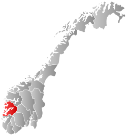
Kvam is a municipality in Hordaland county, Norway. The municipality is located along the Hardangerfjorden in the traditional district of Hardanger. The administrative centre of the municipality is the village of Norheimsund. Other larger settlements in the municipality include Øystese, Bru, Ålvik, Tørvikbygd, Omastranda, and Mundheim. The largest settlement in the municipality is the Norheimsund/Øystese urban area which has a population (2013) of 4,291.[2] Historically, the municipality was named Vikør.[3]
General information

Name
The Old Norse form of the name was Hvammr, identical with the word hvammr which means "(small) valley", possibly referring the Steinsdalen valley west of Norheimsund.[3] Before 1912, the municipality was named Vikør, which comes from the Old Norse word Vikøyar. It was the name of the farm on which the old Vikøy Church was located.[4]
Coat-of-arms
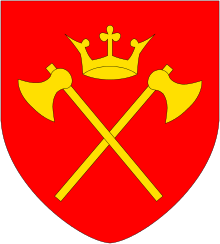
The coat-of-arms is from modern times; they were granted on 27 November 1981. The blue and silver arms are designed to look like the Fyksesund, a narrow fjord in the municipality. The shape of the fjord is that it is narrower in the middle and this is symbolized in the design of the coat-of-arms.[5]
Churches
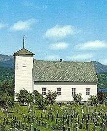
The Church of Norway has four parishes (sokn) within the municipality of Kvam. It is part of the Hardanger og Voss deanery in the Diocese of Bjørgvin.
| Parish (Sokn) | Church Name | Location of the Church | Year Built |
|---|---|---|---|
| Strandebarm | Strandebarm Church | Bru | 1876 |
| Vikøy | Norheimsund Church | Norheimsund | 1992 |
| Vikøy Church | Vikøy | 1838 | |
| Øystese | Øystese Church | Øystese | 1868 |
| Ålvik | Ålvik Church | Ålvik | 1962 |
Geography

Kvam municipality borders the municipality of Voss to the north; Vaksdal, Samnanger, and Fusa to the west; Granvin to the east; and the Hardangerfjorden to the south. The Fyksesund fjord branches off the main fjord and heads north into the municipality. The Fyksesund Landscape Park surrounds the inner part of the Fyksesund, north of the Fyksesund Bridge. The largest lakes are Bjølsegrøvvatnet and Holmavatnet. In addition a portion of Hamlagrøvatnet is located in Kvam. The Kvamskogen plateau lies west of Norheimsund and is home to hundreds of holiday cabins. The Steinsdalsfossen waterfall, located in Steine is one of the most visited tourist attractions in Norway.
History
| Historical population | ||
|---|---|---|
| Year | Pop. | ±% |
| 1951 | 5,530 | — |
| 1960 | 6,525 | +18.0% |
| 1970 | 9,017 | +38.2% |
| 1980 | 8,733 | −3.1% |
| 1990 | 8,773 | +0.5% |
| 2000 | 8,592 | −2.1% |
| 2010 | 8,360 | −2.7% |
| 2014 | 8,584 | +2.7% |
| Source: Statistics Norway. | ||

The old parish of Vikør was established as a municipality on 1 January 1838 (see formannskapsdistrikt). According to the 1835 census, the parish had a population of 2,321.[6] On 1 January 1882, a small area of Ullensvang municipality (population: 22) was transferred to Vikør. In 1912, the municipality changed its name from "Vikør" to "Kvam".[7]
On 1 January 1965, there were many major municipal changes in Norway due to the decisions of the Schei Committee. The Åsgrenda area on the Folgefonna peninsula (population: 61) was moved from Kvam to neighboring Ullensvang municipality. On the same date, Kvam also gained a considerable amount of territory, making it a much larger municipality. The following places were merged, giving the new Kvam municipality a population of 9,119.[8]
- Most of Kvam municipality (population: 6,759) except for Åsegrenda which was moved to Ullensvang
- The part of Jondal municipality that was located on the northwest side of the Hardangerfjord, around the village of Tørvikbygd (population: 515)
- Most of Strandebarm municipality (population: 1,545), except for the Kysnesstranda area which went to Jondal
- The Mundheim area of Varaldsøy (population: 300).
Government
All municipalities in Norway, including Kvam, are responsible for primary education (through 10th grade), outpatient health services, senior citizen services, unemployment and other social services, zoning, economic development, and municipal roads. The municipality is governed by a municipal council of elected representatives, which in turn elect a mayor.
In 2007, Kvam participated in a trial where the mayor was directly elected. The sitting mayor, Astrid Selsvold, won the election with 26.7% of the votes.
Municipal council

The municipal council (Kommunestyre) of Kvam is made up of 27 representatives that are elected to every four years. For 2011–2015, the party breakdown is as follows:[9]
| Party Name | Name in Norwegian | Number of representatives | |
|---|---|---|---|
| Labour Party | Arbeiderpartiet | 4 | |
| Progress Party | Framstegspartiet | 3 | |
| Conservative Party | Høgre | 4 | |
| Christian Democratic Party | Kristelig Folkeparti | 4 | |
| Centre Party | Senterpartiet | 6 | |
| Socialist Left Party | Sosialistisk Venstreparti | 1 | |
| Liberal Party | Venstre | 2 | |
| Local Lists | Lokale lister | 3 | |
| Total number of members: | 27 | ||
Notable residents
- Jon Flatabø (1846–1930), writer
- Jon Fosse, a Norwegian author and dramatist
- Valgerd Svarstad Haugland, a Norwegian teacher, politician and civil servant
- Per Øyvind Heradstveit, a Norwegian television journalist and non-fiction writer
- Svein Rosseland, a Norwegian astrophysicist and a pioneer in the field of theoretical astrophysics
- Geirr Tveitt, a central figure of the national movement in Norwegian cultural life during the 1930s
References
| Wikimedia Commons has media related to Kvam. |
| Look up Kvam in Wiktionary, the free dictionary. |
| Wikivoyage has a travel guide for Hordaland. |
| Wikivoyage has a travel guide for Kvamskogen. |
- ↑ "Navn på steder og personer: Innbyggjarnamn" (in Norwegian). Språkrådet. Retrieved 2015-12-01.
- ↑ Statistisk sentralbyrå (1 January 2013). "Urban settlements. Population and area, by municipality.".
- 1 2 Store norske leksikon. "Kvam – kommune i Hordaland" (in Norwegian). Retrieved 2014-07-04.
- ↑ Rygh, Oluf (1919). Norske gaardnavne: Nordre Bergenhus amt (in Norwegian) (12 ed.). Kristiania, Norge: W. C. Fabritius & sønners bogtrikkeri. pp. 492 and 506.
- ↑ "Civic heraldry of Norway - Norske Kommunevåpen". Heraldry of the World. Retrieved 2014-07-04.
- ↑ Registreringssentral for historiske data. "Hjemmehørende folkemengde Hordaland 1801-1960" (in Norwegian). University of Tromsø.
- ↑ Kvam municipality. "Arkivkatalogar" (in Norwegian).
- ↑ Jukvam, Dag (1999). "Historisk oversikt over endringer i kommune- og fylkesinndelingen" (PDF) (in Norwegian). Statistisk sentralbyrå.
- ↑ "Members of the local councils, by party/electoral lists and municipality" (in Norwegian). Statistics Norway. 2011.