Grade I listed buildings in Neath Port Talbot
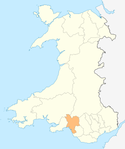
Neath Port Talbot shown within Wales
In the United Kingdom, the term listed building refers to a building or other structure officially designated as being of special architectural, historical, or cultural significance; Grade I structures are those considered to be "buildings of exceptional interest".[1] Listing was begun by a provision in the Town and Country Planning Act 1947. Once listed, strict limitations are imposed on the modifications allowed to a building's structure or fittings. In Wales,[2] the authority for listing under the Planning (Listed Buildings and Conservation Areas) Act 1990[3] rests with Cadw.
Buildings
| Name | Location | Date Listed | Grid Ref.[note 1] Geo-coordinates |
Function | Notes | HB No[note 2] | Image |
|---|---|---|---|---|---|---|---|
| St Mary's Abbey Church | Margam | 11 December 1952 | SS8015286291 51°33′46″N 3°43′49″W / 51.562742369017°N 3.7303819256734°W |
Church | Located at the end of a short lane which runs NE off the A48. The Stones Museum is within the churchyard. The S doorway faces into Margam Park. | 14148 | 
|
| Ruins of Chapter House and Vestibule of St Mary's Abbey | Margam | 11 December 1952 | SS8019786264 51°33′45″N 3°43′47″W / 51.562509293815°N 3.72972384304°W |
Ruin | Located in a central position in the gardens at Margam Park, to the NE of the orangery. | 14149 | 
|
| Ruined Undercroft at St Mary's Abbey | Margam | 11 December 1952 | SS8019086230 51°33′44″N 3°43′47″W / 51.562202237273°N 3.729813179372°W |
Ruin | Located to the S of the Chapter House and E of Margam Orangery. | 14150 | 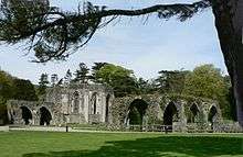
|
| Margam Orangery | Margam | 11 December 1952 | SS8011786234 51°33′44″N 3°43′51″W / 51.56222264207°N 3.7308671467272°W |
Orangery | The centre-piece in the gardens at Margam Park. The abbey remains are immediately to the NE, with the broadwalk leading up to Margam Castle further E. | 14152 | 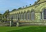
|
| Ivy Cottage including Facade of Former Banqueting House | Margam | 11 December 1952 | SS8008086283 51°33′46″N 3°43′53″W / 51.56265513474°N 3.7314173887393°W |
Cottage | Located along the N boundary of the gardens, N of the Orangery and SE of the kitchen gardens. The facade faces W into the park, whilst the cottage is outside the park boundary. | 14153 | 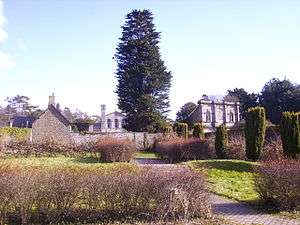
|
| Margam Castle | Margam | 24 February 1975 | SS8049486284 51°33′46″N 3°43′32″W / 51.562752179964°N 3.7254481060496°W |
Country House | Located in a high and prominent position at the E end of the gardens in Margam Park. Approached from the SW by a new drive. | 14170 | 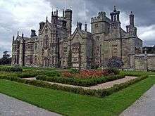
|
| Church of St Catharine | Baglan | 1 September 1976 | SS7526992225 51°36′54″N 3°48′10″W / 51.615009419334°N 3.8029001579839°W |
Church | Prominently sited at the junction between St Illtyd's Drive and Church Road. The church is set within a walled churchyard with Baglan brook on the SE side. | 14171 | 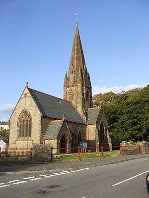 |
See also
Notes
- ↑ Sometimes known as OSGB36, the grid reference is based on the British national grid reference system used by the Ordnance Survey.
- ↑ The "HB Number" is a unique number assigned to each listed building by Cadw.
References
- ↑ "Buildings & Conservation Areas". Cadw. Retrieved 18 June 2013.
- ↑ "Coflein". online database of RCAHMW. Royal Commission on the Ancient and Historical Monuments of Wales. Retrieved 28 November 2016.
- ↑ "Planning (Listed Buildings and Conservation Areas) Act 1990". The National Archives. Retrieved 18 June 2013.
External links
![]() Media related to Grade I listed buildings in Neath Port Talbot at Wikimedia Commons
Media related to Grade I listed buildings in Neath Port Talbot at Wikimedia Commons
| Communities |
| |
|---|---|---|
| Towns and villages |
| |
| Castles | ||
| Rivers | ||
| Topics | ||
This article is issued from Wikipedia - version of the 11/28/2016. The text is available under the Creative Commons Attribution/Share Alike but additional terms may apply for the media files.