Grade I listed buildings in Anglesey

Anglesey shown within Wales
In the United Kingdom, the term listed building refers to a building or other structure officially designated as being of special architectural, historical, or cultural significance; Grade I structures are those considered to be "buildings of exceptional interest".[1] Listing was begun by a provision in the Town and Country Planning Act 1947. Once listed, strict limitations are imposed on the modifications allowed to a building's structure or fittings. In Wales,[2] the authority for listing under the Planning (Listed Buildings and Conservation Areas) Act 1990[3] rests with Cadw.
Buildings
| Name | Location | Date Listed | Grid Ref.[note 1] Geo-coordinates |
Function | Notes | HB No[note 2] | Image |
|---|---|---|---|---|---|---|---|
| St Mary's Church and churchyard walls, Tal-y-llyn | Aberffraw | 4 May 1971 | SH3666572869 53°13′40″N 4°26′54″W / 53.227674666797°N 4.4483181416486°W |
Church | In an isolated location at the E side of a country lane c. 4.25km NE of Aberffraw and c. 3.75km SW of Gwalchmai; the chapel lies within an enclosed circular churchyard. | 5275 | 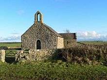
|
| St Eilian's Church | Llaneilian | 5 December 1970 | SH4697892897 53°24′38″N 4°18′13″W / 53.410633389101°N 4.303636237527°W |
Church | In Llaneilian village, set in a large rectangular churchyard with stone boundary walls and two sets of gates to south and west. | 5363 | 
|
| St Mary's Church, Llanfair-yng-Nghornwy | Cylch-y-Garn | 5 December 1970 | SH3272290847 53°23′16″N 4°31′01″W / 53.387887107158°N 4.5168083840824°W |
Church | Reached by a trackway and set back, within a sub-rectangular churchyard, from the NW side of the road at the SE end of the village of Llanfair-yng-Nghornwy. | 5380 | 
|
| St Cybi's Church | Holyhead | 26 September 1951 | SH2471482620 53°18′41″N 4°37′57″W / 53.31141170422°N 4.6325287593125°W |
Church | In chuchyard overlooking inner harbour, entered by archway from Market Square. | 5413 | 
|
| Walls of upper churchyard, Market Square | Holyhead | 26 September 1951 | SH2469782619 53°18′41″N 4°37′58″W / 53.311397081521°N 4.6327830830669°W |
Walls | Remains of a Roman fort, with walls reaching up to 4m in height. | 5415 | 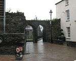
|
| The Holy Well and Cell | Penmon (Llangoed) | 2 May 1952 | SH6305780797 53°18′23″N 4°03′24″W / 53.306370089337°N 4.0566719418153°W |
Well | Set back, along a trackway, from the N side of a country road leading to the SE tip of the island at Black Point, or Trwyn Du, Penmon. The Holy Well and Cell are c50m NNE of the Priory Church of St Seiriol at Penmon. | 5437 | 
|
| Plas Newydd | Llandaniel Fab | 30 January 1968 | SH5208169588 53°12′10″N 4°12′58″W / 53.202732716052°N 4.2160542241599°W |
House | Located 1.5km SW of Llanfairpwll on the A4080. Sited on an artificial terrace alongside the Menai Strait, overlooking the Snowdonia mountains to the E. | 5462 | 
|
| St Cadwaladr's Church | Llangadwaladr (Bodorgan) | 30 January 1968 | SH3837169271 53°11′45″N 4°25′15″W / 53.195885053216°N 4.4209629538485°W |
Church | Located within an enclosed rectangular churchyard (now extended to the SE); set back from the N side of the A4080 in the hamlet of Llangadwaladr. | 5505 | 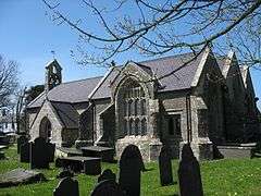
|
| Priory Church of St Seiriol | Penmon (Llangoed) | 30 January 1968 | SH6303380731 53°18′21″N 4°03′25″W / 53.30577°N 4.05700°W |
Church | Slightly set back from the N side of a country road which leads down to the SE tip of the island at Black Point, or Trwyn Du, Penmon. | 5525 | 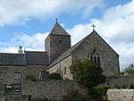
|
| Remains of monastic settlement including tower and walls | Puffin Island (Llangoed) | 30 January 1968 | SH6516782162 53°19′09″N 4°01′32″W / 53.31917°N 4.02561°W |
Monastery (ruined) | A partly ruined 12th-century church, located in the central part of the island, off the SE tip of the Isle of Anglesey. | 5528 | 
|
| Beaumaris Castle | Beaumaris | 23 September 1950 | SH6072476245 53°15′54″N 4°05′23″W / 53.264871099534°N 4.0896627192241°W |
Castle | At the E end of Castle Street. | 5574 | 
|
| Beaumaris Gaol | Beaumaris | 23 September 1950 | SH6035776082 53°15′48″N 4°05′42″W / 53.26331021796°N 4.0950896078323°W |
Gaol | A large building occupying the whole block bounded by Bunkers Hill, Steeple Lane and Gaol Street. | 5579 | 
|
| Perimeter walls of Beaumaris Gaol | Beaumaris | 23 September 1950 | SH6035176094 53°15′48″N 4°05′43″W / 53.263416427782°N 4.0951847696159°W |
Walls | Occupying the block defined by Steeple Lane, Bunkers Hill, Gaol Street, and a narrow alley at the S end. | 5580 | 
|
| The Bulkeley Hotel including screen wall to lefthand courtyard | Beaumaris | 23 September 1950 | SH6058376056 53°15′47″N 4°05′30″W / 53.263136239904°N 4.0916923316134°W |
Hotel | Prominently sited with one front in the centre of Castle Street, and the opposite front forming one of the most conspicuous buildings facing The Green. | 5588 | 
|
| Church of SS Mary and Nicholas | Beaumaris | 23 September 1950 | SH6041076128 53°15′49″N 4°05′40″W / 53.263737403074°N 4.094315775666°W |
Church | In a large churchyard with Church Street to the E and Steeple Lane to the W. | 5620 | 
|
| Remains of medieval town wall | Beaumaris | 23 September 1950 | SH6043376235 53°15′53″N 4°05′38″W / 53.26470462051°N 4.0940181715659°W |
Town Wall | Behind Nos 40-42 and 38 Church Street. | 5633 |
|
| Menai Suspension Bridge | Menai Bridge | 27 May 1949 | SH5565271450 53°13′14″N 4°09′49″W / 53.220441781224°N 4.1634755290463°W |
Bridge | Spanning the Menai Strait S of Menai Bridge. | 18572 | 
|
| Refectory at Penmon Priory | Llangoed | 17 July 2002 | SH6304480709 53°18′20″N 4°03′25″W / 53.305576227196°N 4.0568288951421°W |
Refectory | Slightly set back from the N side of a country road leading to the SE tip of the island at Black Point, or Trwyn Du, Penmon. The Refectory forms the S side of a cloister yard; abutted by the Priory house at the NW corner. | 26764 | 
|
| Hafotty/Hafoty | Llansadwrn | 28 May 2003 | SH5621678172 53°16′52″N 4°09′29″W / 53.280974669647°N 4.1580725892502°W |
House | Medieval hall house dating from the 14th-century, built to an H-shaped plan within private grounds.[4] NW side of a country road which leads NNE off the B5109 towards Llanddona. | 81136 | 
|
| 1 Victoria Terrace, including short section of forecourt railings to left | Beaumaris | 23 September 1950 | SH6065676060 53°15′47″N 4°05′26″W / 53.263191392856°N 4.0906004211496°W |
House | Victoria Terrace is the most prominent building facing The Green. No 1, at the L end, is entered from The Green. | 5636 | 
|
| 2 Victoria Terrace | Beaumaris | 23 September 1950 | SH6066476062 53°15′48″N 4°05′26″W / 53.26321146427°N 4.090481444016°W |
House | Victoria Terrace is the most prominent building facing The Green. No 2 is entered from The Green. | 84703 |
|
| 3 Victoria Terrace | Beaumaris | 23 September 1950 | SH6067076064 53°15′48″N 4°05′25″W / 53.26323100913°N 4.0903924302334°W |
House | Victoria Terrace is the most prominent building facing The Green. No 3 is entered from The Green. | 84719 |
|
| 4 Victoria Terrace | Beaumaris | 23 September 1950 | SH6067776067 53°15′48″N 4°05′25″W / 53.263259799887°N 4.0902888728919°W |
House | Victoria Terrace is the most prominent building facing The Green. No 4 is entered from The Green. | 84727 |
|
| 5 Victoria Terrace | Beaumaris | 23 September 1950 | SH6068676070 53°15′48″N 4°05′25″W / 53.263289116939°N 4.0901553518997°W |
House | Victoria Terrace is the most prominent building facing The Green. No 5 is entered from The Green. | 84735 |
|
| 6 Victoria Terrace | Beaumaris | 23 September 1950 | SH6069376074 53°15′48″N 4°05′24″W / 53.263326890249°N 4.0900522324696°W |
House | Victoria Terrace is the most prominent building facing The Green. No 6 is entered from The Green. | 84743 |
|
| 7 Victoria Terrace | Beaumaris | 23 September 1950 | SH6069776083 53°15′48″N 4°05′24″W / 53.263408787759°N 4.0899962492295°W |
House | Victoria Terrace is the most prominent building facing The Green. No 7 is entered from The Green. | 84747 |
|
| 8 Victoria Terrace | Beaumaris | 23 September 1950 | SH6070176089 53°15′48″N 4°05′24″W / 53.26346373697°N 4.089938951195°W |
House | Victoria Terrace is the most prominent building facing The Green. No 8 is entered from The Green. | 84750 |
|
| 9 Victoria Terrace | Beaumaris | 23 September 1950 | SH6070676095 53°15′49″N 4°05′24″W / 53.26351894931°N 4.0898666711768°W |
House | Victoria Terrace is the most prominent building facing The Green. No 9 is entered from The Green. | 84752 |
|
| 10 Victoria Terrace | Beaumaris | 23 September 1950 | SH6071076102 53°15′49″N 4°05′23″W / 53.263582881219°N 4.089809811°W |
House | Victoria Terrace is the most prominent building facing The Green. No 10, at the R end of the terrace, is entered from Mona Place. | 84680 |
|
| 12 Victoria Terrace | Beaumaris | 23 September 1950 | SH6066276066 53°15′48″N 4°05′26″W / 53.263246868824°N 4.0905131607077°W |
House | Victoria Terrace is the most prominent building facing The Green. No 12 is entered from a balcony at the rear. | 84683 |
|
| 13 Victoria Terrace | Beaumaris | 23 September 1950 | SH6066876069 53°15′48″N 4°05′26″W / 53.263275396464°N 4.09042458516°W |
House | Victoria Terrace is the most prominent building facing The Green. No 13 is entered from a balcony at the rear. | 84684 |
|
| 14 Victoria Terrace | Beaumaris | 23 September 1950 | SH6067476072 53°15′48″N 4°05′25″W / 53.263303924038°N 4.0903360094931°W |
House | Victoria Terrace is the most prominent building facing The Green. No 14 is entered from a balcony at the rear. | 84686 |
|
| 15 Victoria Terrace | Beaumaris | 23 September 1950 | SH6068276074 53°15′48″N 4°05′25″W / 53.263323995191°N 4.0902170319174°W |
House | Victoria Terrace is the most prominent building facing The Green. No 15 is entered from a balcony at the rear. | 84689 |
|
| 16 Victoria Terrace | Beaumaris | 23 September 1950 | SH6068876078 53°15′48″N 4°05′24″W / 53.263361505369°N 4.0901288942408°W |
House | Victoria Terrace is the most prominent building facing The Green. No 16 is entered from a balcony at the rear. | 84691 |
|
| 17 Victoria Terrace | Beaumaris | 23 September 1950 | SH6069276085 53°15′48″N 4°05′24″W / 53.2634254374°N 4.0900720346612°W |
House | Victoria Terrace is the most prominent building facing The Green. No 17 is entered from a balcony at the rear. | 84693 |
|
| 18 Victoria Terrace | Beaumaris | 23 September 1950 | SH6069776092 53°15′49″N 4°05′24″W / 53.263489632576°N 4.0900001930872°W |
House | Victoria Terrace is the most prominent building facing The Green. No 18 is entered from a balcony at the rear. | 84696 |
|
| 19 Victoria Terrace | Beaumaris | 23 September 1950 | SH6070276098 53°15′49″N 4°05′24″W / 53.263544844952°N 4.0899279131061°W |
House | Victoria Terrace is the most prominent building facing The Green. No 19 is entered from The Green. | 84698 |
|
| 20 Victoria Terrace | Beaumaris | 23 September 1950 | SH6070576106 53°15′49″N 4°05′24″W / 53.263617496492°N 4.0898864730432°W |
House | Victoria Terrace is the most prominent building facing The Green. No 20 is entered from The Green. | 84708 | |
See also
Notes
- ↑ Sometimes known as OSGB36, the grid reference is based on the British national grid reference system used by the Ordnance Survey.
- ↑ The "HB Number" is a unique number assigned to each listed building by Cadw.
References
- ↑ "Buildings & Conservation Areas". Cadw. Retrieved 18 June 2013.
- ↑ "Coflein". online database of RCAHMW. Royal Commission on the Ancient and Historical Monuments of Wales. Retrieved 28 November 2016.
- ↑ "Planning (Listed Buildings and Conservation Areas) Act 1990". The National Archives. Retrieved 18 June 2013.
- ↑ "Open Doors 2011: Isle of Anglesey". Wales Online. 4 August 2011. Retrieved 3 March 2016.
External links
![]() Media related to Grade I listed buildings in Anglesey at Wikimedia Commons
Media related to Grade I listed buildings in Anglesey at Wikimedia Commons
This article is issued from Wikipedia - version of the 11/28/2016. The text is available under the Creative Commons Attribution/Share Alike but additional terms may apply for the media files.