Grade I listed buildings in Denbighshire
Denbighshire shown within Wales
In the United Kingdom, the term listed building refers to a building or other structure officially designated as being of special architectural, historical, or cultural significance; Grade I structures are those considered to be "buildings of exceptional interest".[1] Listing was begun by a provision in the Town and Country Planning Act 1947. Once listed, strict limitations are imposed on the modifications allowed to a building's structure or fittings. In Wales,[2] the authority for listing under the Planning (Listed Buildings and Conservation Areas) Act 1990[3] rests with Cadw.
Buildings
| Name | Location | Date Listed | Grid Ref.[note 1] Geo-coordinates |
Function | Notes | HB No[note 2] | Image |
|---|---|---|---|---|---|---|---|
| Plas Uchaf | Cynwyd | 6 April 1952 | SJ0531642722 52°58′25″N 3°24′41″W / 52.973480895127°N 3.4114556447492°W |
House | Located off the W side of a lane which runs N from Cynwyd to Melin Rug. The front faces S, the ground sloping downhill to the E. | 663 | 
|
| Rhug Chapel | Corwen | 20 October 1966 | SJ0649543889 52°59′03″N 3°23′39″W / 52.984175476174°N 3.3942417424992°W |
Chapel | 671 | 
| |
| Llangar Church (All Saints) | Llangar, Cynwyd | 20 October 1966 | SJ0635442452 52°58′16″N 3°23′45″W / 52.971237189749°N 3.3959249229438°W |
Church | In a rural location on the E banks of the River Dee, and set down from B4401. The church is set in a large churchyard, the stone boundary wall probably C18, and with many contemporary table tombs. | 704 | 
|
| St Mary's Church | Derwen | 19 July 1966 | SJ0703150728 53°02′45″N 3°23′18″W / 53.045727515668°N 3.3882321080786°W |
Church | At the centre of the village of Derwen. | 725 | 
|
| Church of St Garmon | Llanarmon-yn-Iâl | 19 July 1966 | SJ1907556158 53°05′47″N 3°12′36″W / 53.096489235474°N 3.2099917633009°W |
Church | Situated in the centre of Llanarmon village. | 735 | 
|
| Parish Church of St Meugan | Llanbedr Dyffryn Clwyd | 19 July 1966 | SJ1400257761 53°06′36″N 3°17′10″W / 53.110100221693°N 3.286161480325°W |
Church | Located at the southern boundary of the community, some 1.5km SW of Llanbedr village and approximately 1.5km E of Ruthin; set within its own raised and partly revetted churchyard, with a particularly good series of C18 and C19 monuments. | 739 | 
|
| Church of St Cynhafal | Llangynhafal | 19 July 1966 | SJ1331363400 53°09′38″N 3°17′53″W / 53.160664164341°N 3.2979783344756°W |
Church | Reached by a minor road east of Llangynhafal. The churchyard is circular, considerably raised above road level on the west, and partly surrounded by a rubble stone wall. War memorial set in west wall of churchyard. Iron gates; winding path from west. | 786 | 
|
| Parish Church of St Dyfnog | Llanrhaeadr-yng-Nghinmeirch | 19 July 1966 | SJ0816763375 53°09′34″N 3°22′30″W / 53.159575329704°N 3.3749127687346°W |
Church | Picturesquely-sited in the village centre, set back from the road within its own walled churchyard. | 792 | 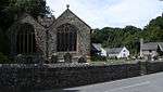
|
| St Saeran's Church | Llanynys | 19 July 1966 | SJ1031962672 53°09′13″N 3°20′33″W / 53.15362530365°N 3.3425401162321°W |
Church | Located in the centre of the small village of Llanynys towards the north-eastern boundary of the community. | 808 | 
|
| Ruthin Castle | Ruthin | 24 October 1950 | SJ1233558051 53°06′45″N 3°18′40″W / 53.112434511512°N 3.3111366185518°W |
Castle | Situated on a rise at the S end of the town, the entrance drive continuing S from Castle Street. | 825 | _27.JPG)
|
| Nantclwyd y Dre (Nantclwyd House) |
Ruthin | 24 October 1950 | SJ1236158185 53°06′49″N 3°18′39″W / 53.113642999487°N 3.3107849343471°W |
House | Situated in a block of buildings in Castle Street | 833 | 
|
| Collegiate and Parochial Church of St Peter | Ruthin | 24 October 1950 | SJ1236258376 53°06′55″N 3°18′39″W / 53.1153596091°N 3.3108222191707°W |
Church | Located off the N side of St Peter's Square, in the centre of Ruthin. | 905 | 
|
| Parish Church of St Marcella (also known as Whitchurch) | Denbigh | 24 October 1950 | SJ0713866233 53°11′06″N 3°23′28″W / 53.185079227083°N 3.3911282959194°W |
Church | Located in open countryside within Denbigh Green, approximately 1.6km SE of Denbigh; within its own rubble-walled churchyard. Also known as Whitchurch. | 952 | 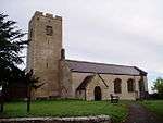
|
| Town Wall, including North-East, Countess and Goblin Towers | Denbigh | 24 October 1950 | SJ0524465805 53°10′51″N 3°25′10″W / 53.18089859994°N 3.4193352920837°W |
Town wall | Defining the Old Town boundary in a long arc to the E of the castle and rising dramatically at the top of a wooded, craggy hill-slope. | 954 | .jpg)
|
| Denbigh Castle | Denbigh | 2 February 1981 | SJ0516365811 53°10′51″N 3°25′14″W / 53.180938059592°N 3.4205487037457°W |
Castle | Prominently-sited at the southern end of the Old Town, with commanding views over the Vale of Clwyd. | 968 | 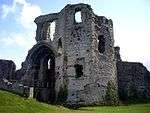
|
| Tower of St Hilary's Church | Denbigh | 24 October 1950 | SJ0521165903 53°10′54″N 3°25′11″W / 53.181773350603°N 3.4198580115459°W |
Church tower | Located within the walls of the old town immediately N of and below the castle. | 969 | 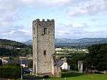
|
| Leicester's Church (Remains) | Denbigh | 24 October 1950 | SJ0529365952 53°10′56″N 3°25′07″W / 53.182228298792°N 3.4186459320215°W |
Church (ruined) | Located within the old walled town on Castle Hill, some 50m NE of the tower of St Hilary's Church. | 970 | 
|
| Burgess Gate | Denbigh | 2 February 1981 | SJ0515465995 53°10′57″N 3°25′15″W / 53.182589896527°N 3.4207379861226°W |
Gate | On the northern side of the Old Town of Denbigh, at the lower end of the street. | 1020 | 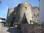
|
| Foxhall Newydd | Henllan | 24 October 1950 | SJ0298367518 53°11′45″N 3°27′13″W / 53.195883381667°N 3.4536764916042°W |
Country House | Located at the southern edge of Foxhall Woods, some 250m W of Foxhall and 1km SE of Henllan; accessed via a track running W from Foxhall. | 1055 | 
|
| Llangollen Bridge | Llangollen | 24 April 1951 | SJ2151142167 52°58′16″N 3°10′13″W / 52.971113532805°N 3.1702109153192°W |
Bridge | Spans the River Dee at the N end of the main street. | 1080 | 
|
| St Collen's Parish Church | Llangollen | 24 April 1951 | SJ2167241976 52°58′10″N 3°10′04″W / 52.969420542288°N 3.1677677705985°W |
Church | Towards the edge of the town centre. | 1164 | 
|
| Trevor Hall | Llangollen | 6 July 1952 | SJ2563242295 52°58′22″N 3°06′32″W / 52.972852499149°N 3.1088885942724°W |
Hall | Set in a wooded hillside location overlooking its own parkland and the eastern end of the vale of Llangollen. | 1350 | 
|
| Bodrhyddan Hall | Rhuddlan | 24 September 1951 | SJ0460278774 53°17′50″N 3°25′58″W / 53.297322878154°N 3.4328266185826°W |
Hall | Set in parkland approx. lkm east of Rhuddlan. | 1361 | 
|
| St Asaph Cathedral | St Asaph | 16 November 1962 | SJ0389674310 53°15′25″N 3°26′31″W / 53.257082106226°N 3.4420645905056°W |
Cathedral | Situated in the town centre | 1460 | 
|
| Rhuddlan Castle | Rhuddlan | 11 October 1994 | SJ0248977913 53°17′21″N 3°27′51″W / 53.28920078526°N 3.4642543595051°W |
Castle | Prominently sited on the east bank of the River Clwyd to the SE of the town. | 14977 | 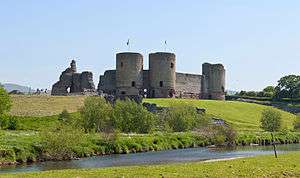
|
| Pillar of Eliseg | Llantysilio | 6 July 1963 | SJ2026744525 52°59′32″N 3°11′22″W / 52.992121552838°N 3.1893126610102°W |
Pillar | The pillar is raised on a tumulus, approximately 50m from the road, and 400m N of Valle Crucis Abbey | 19678 | 
|
| Valle Crucis Abbey | Llantysilio | 22 April 1998 | SJ2044744139 52°59′19″N 3°11′12″W / 52.988679287644°N 3.1865365488523°W |
Abbet (ruined) | The abbey lies in the lower Eglwyseg valley between the main road and the river, approximately 0.9km N of Llangollen. | 19693 | 
|
| Town Wall: Western Section | Denbigh | 27 February 2004 | SJ0508865925 53°10′55″N 3°25′18″W / 53.181949078468°N 3.4217044698133°W |
Town Wall | Defining the old Town boundary, running W and S from the Burgess Gate to the site of the Exchequer Tower. | 82445 |  |
See also
Notes
- ↑ Sometimes known as OSGB36, the grid reference is based on the British national grid reference system used by the Ordnance Survey.
- ↑ The "HB Number" is a unique number assigned to each listed building by Cadw.
References
- ↑ "Buildings & Conservation Areas". Cadw. Retrieved 18 June 2013.
- ↑ "Coflein". online database of RCAHMW. Royal Commission on the Ancient and Historical Monuments of Wales. Retrieved 28 November 2016.
- ↑ "Planning (Listed Buildings and Conservation Areas) Act 1990". The National Archives. Retrieved 18 June 2013.
External links
![]() Media related to Grade I listed buildings in Denbighshire at Wikimedia Commons
Media related to Grade I listed buildings in Denbighshire at Wikimedia Commons
This article is issued from Wikipedia - version of the 11/28/2016. The text is available under the Creative Commons Attribution/Share Alike but additional terms may apply for the media files.