Grade I listed buildings in Conwy County Borough
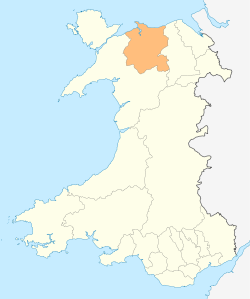
Conwy County Borough shown within Wales
In the United Kingdom, the term listed building refers to a building or other structure officially designated as being of special architectural, historical, or cultural significance; Grade I structures are those considered to be "buildings of exceptional interest".[1] Listing was begun by a provision in the Town and Country Planning Act 1947. Once listed, strict limitations are imposed on the modifications allowed to a building's structure or fittings. In Wales,[2] the authority for listing under the Planning (Listed Buildings and Conservation Areas) Act 1990[3] rests with Cadw.
Buildings
| Name | Location | Date Listed | Grid Ref.[note 1] Geo-coordinates |
Function | Notes | HB No[note 2] | Image |
|---|---|---|---|---|---|---|---|
| Waterloo Bridge | Bro Garmon | 23 June 1967 | SH7986255733 53°05′07″N 3°47′43″W / 53.085271846947°N 3.7951765769129°W |
Bridge | Spanning the Afon Conwy and carrying the A5 from Betws-y-Coed to Pentrefoelas. | 121 | 
|
| Church of St Nefydd and St Mary | Llannefydd | 30 January 1968 | SH9821070599 53°13′22″N 3°31′34″W / 53.222674374495°N 3.5260785573515°W |
Church | Prominently located in the centre of the village within a raised and walled churchyard. | 199 | 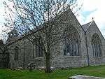
|
| Kinmel Hall | Abergele | 6 October 1970 | SH9810174922 53°15′41″N 3°31′45″W / 53.261498109897°N 3.5290949968566°W |
Mill | Located on an elevated platform site, within extensive parkland, approximately 3 miles SE of Abergele. Access now by driveway off Primrose Hill, St George Village. | 229 | 
|
| Gwrych Castle including attached walls and towers and Stable Block | Llanddulas and Rhyd-y-Foel | 27 October 1950 | SH9285777465 53°17′00″N 3°36′31″W / 53.28331245143°N 3.6085357414179°W |
Castle | About 2km W of centre of Abergele, set dramatically against a wooded hill slope; set back from and above B 4553. | 231 | 
|
| Llwyni Lodge, also known as the Golden Lodge and Gate Lodge | Abergele | 10 April 1973 | SH9804876187 53°16′22″N 3°31′49″W / 53.272854612376°N 3.5302951840043°W |
Lodge | The Lodge stands at the S end of the avenue leading to Kinmel Hall from the N margin of the main A55 Holyhead Road. Sign on gatepost says Golden Lodge. | 242 | 
|
| Hafodunos Hall | Llangernyw | 4 February 1970 | SH8675367035 53°11′18″N 3°41′47″W / 53.188329386691°N 3.6963382691496°W |
House | About 1km WSW of Llangernyw. | 262 |
|
| Gwydir Castle (including gatehouse) | Trefriw | 17 March 1953 | SH7959561037 53°07′58″N 3°48′04″W / 53.132865591752°N 3.8011517450959°W |
House | Located approximately 1km S of Llanrwst at right-angles with the B5106 (Gwydir Road). | 3161 | 
|
| Maenan Hall | Llanddoged and Maenan | 17 March 1953 | SH7942365037 53°10′08″N 3°48′19″W / 53.168764459098°N 3.8052285317698°W |
Hall | Located on a rise approximately 200m E of the A 470, 1.2km NW of Llandogged village; accessed via a long metalled drive leading W off the main road. | 3163 |
|
| Parish Church of St Mary, Caerhun | Caerhun | 13 October 1966 | SH7768370397 53°12′59″N 3°50′00″W / 53.216522304662°N 3.833297538599°W |
Church | Situated on a rise overlooking the river Conwy on the W bank, and occupying the NE corner of the former Roman fort of Canovium; accessed via a metalled lane running E from the B5106 Bettws-y-Coed to Conwy road. | 3167 | 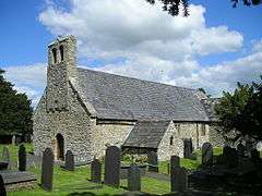
|
| Church of St Gwyddelan, Dolwyddelan | Dolwyddelan | 13 October 1966 | SH7359252294 53°03′11″N 3°53′15″W / 53.052924866203°N 3.8873846555313°W |
Church | In the centre of the village, set back slightly within a low rubble-walled churchyard and surrounded by mature trees. | 3184 | 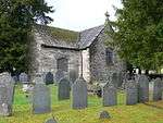
|
| St Celynin's Old Church | Henryd | 13 October 1966 | SH7511873726 53°14′45″N 3°52′23″W / 53.245832227546°N 3.8729944866837°W |
Church | Located on a high plateau in the rocky uplands at the W extremity of the community, near the Cerrig-y-Ddinas hillfort and some 3km W of Henryd village. | 3193 | 
|
| Llanrhychwyn Church | Trefriw | 13 October 1966 | SH7747861610 53°08′15″N 3°49′59″W / 53.137530242636°N 3.832996157464°W |
Church | Situated on an upland plateau approximately 1.2km S of Trefriw and 0.3km E of Lake Geirionydd; set back slightly to the SE of the road between the two. | 3211 | 
|
| Conwy town walls | Conwy | 23 September 1950 | SH7806177694 53°16′56″N 3°49′50″W / 53.282166942359°N 3.8304368218286°W |
Town wall | Enclosing the old town on the W side of the castle. | 3233 | 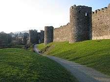
|
| Conwy Suspension Bridge | Conwy | 23 September 1950 | SH7849777494 53°16′50″N 3°49′26″W / 53.280470415217°N 3.8238243283118°W |
Bridge | Spanning Afon Conwy E of the castle and S of the modern road bridge (A547). | 3234 | 
|
| Conwy Railway Bridge | Conwy | 23 September 1950 | SH7849977467 53°16′49″N 3°49′26″W / 53.280228302059°N 3.8237840163964°W |
Bridge | Spanning Afon Conwy on the E side of the castle and S of the modern road and suspension bridges. | 3236 | 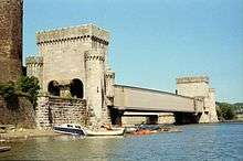
|
| Conwy Castle | Conwy | 23 September 1950 | SH7837677455 53°16′48″N 3°49′32″W / 53.280092234044°N 3.8256231957321°W |
Castle | On the E side of the town overlooking the Conwy estuary. | 3250 | 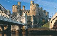
|
| Church of St Benedict, Gyffin | Conwy | 23 September 1950 | SH7764076941 53°16′31″N 3°50′11″W / 53.275304718427°N 3.8364577372839°W |
Church | In a walled churchyard near the main road junction in the village, and immediately S of Afon Gyffin. | 3291 | 
|
| Bodysgallen Hall | Conwy | 23 September 1950 | SH7995379275 53°17′48″N 3°48′10″W / 53.296803716445°N 3.8026721610401°W |
Hall | 3334 | 
| |
| St Mary's Church, Conwy | Conwy | 10 August 1981 | SH7816377526 53°16′50″N 3°49′44″W / 53.280681105542°N 3.828843303738°W |
Church | In a large churchyard enclosed by buildings to Castle Street, High Street, Church Street and Rose Hill Street. | 3353 | 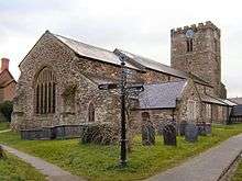
|
| Gloddaeth Hall | Llandudno | 1 October 1951 | SH8024680688 53°18′34″N 3°47′56″W / 53.309564900737°N 3.7988119651514°W |
College | In extensive grounds between A470 (Wormhout Way) and Gloddaeth Lane. Now part of St David's College. | 3411 | _-_geograph.org.uk_-_1356077.jpg)
|
| Pont Fawr, Llanrwst | Llanrwst | 25 January 1951 | SH7984061485 53°08′13″N 3°47′52″W / 53.136946051138°N 3.797659781323°W |
Bridge | Spans Afon Conwy opposite Victoria Hotel. | 3612 | 
|
| St Grwst's Church, Llanrwst | Llanrwst | 25 January 1951 | SH7974361616 53°08′17″N 3°47′57″W / 53.138101098713°N 3.7991581889483°W |
Church | Beyond W end of Tan yr Eglwys, in churchyard overlooking Afon Conwy. | 3622 | 
|
| Plas Mawr | Conwy | 23 September 1950 | SH7808277600 53°16′53″N 3°49′48″W / 53.281327273614°N 3.8300859217661°W |
House | On the corner of High Street and Crown Lane | 3634 | 
|
| Terrace arch and associated garden walls at Gwydir Castle | Trefriw | 30 May 1996 | SH7958861065 53°07′59″N 3°48′05″W / 53.133115573309°N 3.8012668429554°W |
Wall | Located at the NW end of the raised terrace at Gwydir Castle and giving access to the Dutch Garden. | 16936 |
|
| Gwydir Uchaf Chapel | Trefriw | 30 May 1996 | SH7948460933 53°07′55″N 3°48′10″W / 53.1319060692°N 3.8027708359304°W |
Chapel | Strikingly located on an elevated plateau immediately above Gwydir Castle and NW of the Carreg-y-Gwalch; adjacent to Gwydir Uchaf. | 16944 | 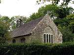
|
| Waterloo Bridge | Betws y Coed | 30 May 1996 | SH7984555727 53°05′07″N 3°47′44″W / 53.085214106441°N 3.7954280146954°W |
Bridge | Carrying the A5 at the SE approach to Betws-y-Coed, spanning the Afon Conwy. | 17827 |
|
| Dolwyddelan Castle | Dolwyddelan | 17 February 1997 | SH7219452329 53°03′10″N 3°54′30″W / 53.052906214292°N 3.9082432642033°W |
Castle | Strikingly located overlooking the modern road on a dramatic eminence 1.5km W of Dolwyddelan village. | 18253 | 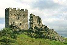 |
See also
Notes
- ↑ Sometimes known as OSGB36, the grid reference is based on the British national grid reference system used by the Ordnance Survey.
- ↑ The "HB Number" is a unique number assigned to each listed building by Cadw.
References
- ↑ "Buildings & Conservation Areas". Cadw. Retrieved 18 June 2013.
- ↑ "Coflein". online database of RCAHMW. Royal Commission on the Ancient and Historical Monuments of Wales. Retrieved 28 November 2016.
- ↑ "Planning (Listed Buildings and Conservation Areas) Act 1990". The National Archives. Retrieved 18 June 2013.
External links
![]() Media related to Grade I listed buildings in Conwy County Borough at Wikimedia Commons
Media related to Grade I listed buildings in Conwy County Borough at Wikimedia Commons
This article is issued from Wikipedia - version of the 11/28/2016. The text is available under the Creative Commons Attribution/Share Alike but additional terms may apply for the media files.