Grade II* listed buildings in Neath Port Talbot
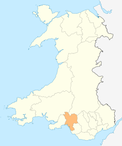
Neath Port Talbot shown within Wales
In the United Kingdom, the term listed building refers to a building or other structure officially designated as being of special architectural, historical, or cultural significance; Grade II* structures are those considered to be "particularly important buildings of more than special interest".[1] Listing was begun by a provision in the Town and Country Planning Act 1947. Once listed, strict limitations are imposed on the modifications allowed to a building's structure or fittings. In Wales, the authority for listing under the Planning (Listed Buildings and Conservation Areas) Act 1990[2] rests with Cadw.
Buildings
| Name | Location | Date Listed | Grid Ref.[note 1] Geo-coordinates |
Function | Notes | HB No[note 2] | Image |
|---|---|---|---|---|---|---|---|
| Church of Saint Cattwg, Blaenhonddan | Blaenhonddan | 20 June 1963 | SS7559298572 51°40′20″N 3°48′02″W / 51.67212°N 3.80050°W |
Church | In a prominent position on a bend on the SE side of Church Road. | 11767 | 
|
| Rheola House | Glynneath | 15 May 1973 | SN8385204211 51°43′28″N 3°40′59″W / 51.72457°N 3.68298°W |
House | In parkland to the N of the B4242 between Resolven and Glynneath. | 11771 | 
|
| Neath Castle | Neath | 1 May 1989 | SS7536697795 51°39′54″N 3°48′13″W / 51.66509°N 3.80348°W |
Castle | 11775 | 
| |
| Church of St Thomas, Neath | Neath | 15 August 1975 | SS7532597673 51°39′50″N 3°48′15″W / 51.66398°N 3.80403°W |
Church | 11776 | 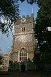
| |
| Parish church of St Illtyd, Neath | Llantwit, Neath | 20 June 1963 | SS7619598038 51°40′03″N 3°47′30″W / 51.66745°N 3.79159°W |
Church | 11797 | 
| |
| Parish church of St David, Neath | Neath | 1 May 1989 | SS7540997504 51°39′45″N 3°48′10″W / 51.66248°N 3.80276°W |
Church | 11818 | 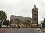
| |
| Aberdulais Aqueduct | Aberdulais, (Blaenhonddan & Tonna) | 29 January 1980 | SS7726999281 51°40′44″N 3°46′35″W / 51.67886°N 3.77651°W |
Viaduct | Ten stone arches create the longest aqueduct in South Wales, built in 1823, to carry the Tennant Canal over the River Neath, west of Aberdulais Basin where it joins the Neath canal. It is also a scheduled monument | 11838 | 
|
| Cefn Coed Colliery, No. 1 Shaft Headframe | Crynant | 16 November 1990 | SN7851503221 51°42′52″N 3°45′36″W / 51.71454°N 3.75987°W |
Colliery headstock | Located at the Cefn Coed Colliery Museum in the Dulais Valley, on the A4109 two miles north of Aberdulais. | 11858 | 
|
| Cefn Coed Colliery, No. 2 Shaft Headframe | Crynant | 16 November 1990 | SN7853003325 51°42′56″N 3°45′35″W / 51.71548°N 3.75969°W |
Headstock | Located at the Cefn Coed Colliery Museum in the Dulais Valley, on the A4109 two miles north of Aberdulais. | 11859 |
|
| Cefn Coed Colliery chimney and boiler house flue | Crynant | 2 April 1991 | SN7855303303 51°42′55″N 3°45′34″W / 51.71529°N 3.75935°W |
Colliery chimney | Located at the Cefn Coed Colliery Museum in the Dulais Valley, on the A4109 two miles north of Aberdulais. The tall brick stack forms a considerable landmark immediately adjacent to the main road. | 11860 | _-_geograph.org.uk_-_204978.jpg)
|
| Cefn Coed Colliery Boilerhouse | Crynant | 2 April 1991 | SN7854203254 51°42′53″N 3°45′34″W / 51.71484°N 3.75949°W |
Boilerhouse | Located at the Cefn Coed Colliery Museum in the Dulais Valley, on the A4109 two miles north of Aberdulais. The boilers are in the centre of the Museum complex, housed beneath a corrugated roof. | 11861 |
|
| Cefn Coed Colliery Engine House Range and Steam Capstan Engine | Crynant | 2 April 1991 | SN7855003213 51°42′52″N 3°45′34″W / 51.71448°N 3.75936°W |
Engine House and capstan | At Cefn Coed Colliery Museum in the Dulais Valley, on the A4109 2 miles N of Aberdulais. The engine house range of 3 gabled buildings adjacent to the main road. The steam capstan engine situated immediately adjacent to W side of the central building. | 11863 | .jpg)
|
| St. Cadoc's Church, Glynneath | Glynneath | 25 February 1993 | SN8698306141 51°44′33″N 3°38′18″W / 51.742558°N 3.638301°W |
Church | Set in a small churchyard to SE of the ruins of Aberpergwm House; reached from the main drive to the house which leads off the main road SW of Glynneath. | 11867 | 
|
| Hen Eglwys | Margam | 11 December 1952 | SS8012486518 51°33′53″N 3°43′51″W / 51.564777°N 3.730863°W |
Church | Located on the hillside, Graig Fawr, north of Margam Park. Accessed by a footpath which leads SW off the road along Cwm Bach. In a prominent and spectacular position. | 14155 | 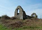
|
| Old Park | Margam | 6 August 1972 | SS8069885022 51°33′05″N 3°43′19″W / 51.551453°N 3.722078°W |
House | The road runs SW off the A48 and the house is at the end. | 14158 | 
|
| Church of St Theodore, Port Talbot | Port Talbot | 24 February 1975 | SS7725589098 51°35′14″N 3°46′23″W / 51.587345°N 3.773136°W |
Church | Set within a rectangular walled churchyard, with memorial park to the R and vicarage and mission room to the L. | 14160 | 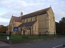
|
| Terrace Walls and Screen at Margam Castle | Margam | 24 February 1975 | SS8044786250 51°33′45″N 3°43′34″W / 51.562437°N 3.726114°W |
Terrace Wall and Screen | On the W side of Margam Castle | 14163 | _(geograph_4125453).jpg)
|
| Beulah Calvinistic Methodist Chapel | Margam | 9 January 1976 | SS7837387422 51°34′21″N 3°45′23″W / 51.572525°N 3.756426°W |
Chapel | Located at the N end of Tollgate Park. | 14172 | 
|
| Ebenezer Chapel, Aberavon | Aberavon | 22 July 1980 | SS7655690201 51°35′50″N 3°47′01″W / 51.597104°N 3.783608°W |
Chapel | In a prominent position in the square between the shopping centre and the Civic Centre, and backing onto the River Afan. | 14174 | 
|
| Llanmihangel Mill | Margam | 9 September 1992 | SS8192182354 51°31′40″N 3°42′13″W / 51.527733°N 3.703551°W |
Mill | Located N of the Afon Cynffig on a track which leads off Marlas Road in Pyle. Part of Llanmihangel Mill Farm. | 14176 |
|
| Bont Fawr Aqueduct | Pontrhydyfen (Pelenna & Cwmavon) | 21 March 2000 | SS7956194070 51°37′57″N 3°44′30″W / 51.632527°N 3.741577°W |
Aqueduct | Spanning the Afan valley, it was built to carry water to Cwmafon iron works. Now a footpath and cycleway. | 23022 | 
|
| Godre'r Rhos Independent Chapel and vestry | Crynant | 29 March 2000 | SN7911906543 51°44′40″N 3°45′08″W / 51.744527°N 3.752284°W |
Chapel | Situated some 1km to the N of Crynant set back on the E side of the minor road to Ystradgynlais. | 23080 | 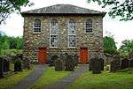
|
| Melincwrt Independent Chapel | Resolven | 29 March 2000 | SN8263301695 51°42′06″N 3°41′59″W / 51.701705°N 3.699776°W |
Chapel | Situated above and SW of Resolven on the E bank of Melin Court Brook. | 23083 | 
|
| Capel Y Tabernacl, Gwaun-Cae-Gurwen | Gwaun-Cae-Gurwen | 29 March 2000 | SN7045010816 51°46′52″N 3°52′46″W / 51.780983°N 3.879373°W |
Chapel | Situated on the N side of Cwmgors some 100m S of the junction of Heol-y-gors and Llwyn Road. | 23088 | .jpg)
|
| Port Talbot War Memorial | Port Talbot | 28 April 2000 | SS7731989063 51°35′13″N 3°46′20″W / 51.587044°N 3.772200°W |
War Memorial | The focal point of the memorial park, in the centre of the main avenue. | 23256 | 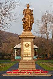
|
| Llanmihangel, Margam | Margam | 25 April 2000 | SS8155882866 51°31′56″N 3°42′32″W / 51.532258°N 3.708954°W |
House | Located at the end of a track which runs N off Marlas Road, Pyle. N of Llanmihangel Mill Farm. | 23262 |
|
| Terrace with Pools and Flower Beds fronting Margam Orangery | Margam | 25 April 2000 | SS8011686215 51°33′43″N 3°43′51″W / 51.562052°N 3.730875°W |
Terrace | Immediately in front of and adjoining Margam Orangery. | 23267 | 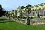
|
| Monastic Baths, Margam | Margam | 25 April 2000 | SS8030486920 51°34′06″N 3°43′42″W / 51.568428°N 3.728405°W |
Baths | Located on the W bank of the Afon Cwm Bach, on the E side of a track. To the N, the track bends round sharply to the E, over the river, and on to Cwm Maelwg Farm. | 23274 |
|
| Service Buildings including Courtyard Walls at Margam Castle | Margam | 24 February 1975 | SS8055286290 51°33′46″N 3°43′29″W / 51.562818°N 3.724614°W |
Castle buildings | Adjoining the E side of Margam Castle, built around 1836 on completion of the main house. Now visitor, educational and office facilities for the Country Park. | 23278 | 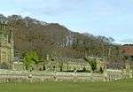
|
| Dock walls and gate between inner dock and outer basin at Briton Ferry Docks | Briton Ferry | 19 May 2000 | SS7372193641 51°37′39″N 3°49′33″W / 51.627389°N 3.825757°W |
Dock Walls and gate | On the S side of the elevated M4 400m E of the River Neath. | 23299 |
|
| Canal Aqueduct over Afon Twrch, including weir | Ystalyfera | 20 December 2002 | SN7727009240 51°46′06″N 3°46′48″W / 51.768361°N 3.780005°W |
Aqueduct | Built in 1798 to carry the Swansea Canal over the Afon Twrch which is the boundary with Powys. It is now a cycle track and is also a scheduled monument. | 80809 | 
|
| Church of Saint Peter, Pontardawe | Pontardawe | 13 March 2003 | SN7226804133 51°43′17″N 3°51′02″W / 51.721346°N 3.850577°W |
Church | Situated on the S side of the High Street in a prominent position. | 80986 | 
|
| No. 1 Blast Furnace at former Neath Abbey Ironworks | Dyffryn Clydach | 22 December 2003 | SS7379397785 51°39′53″N 3°49′34″W / 51.664646°N 3.826213°W |
Blast Furnace | On W side of the River Clydach in Neath Abbey. At 16.2 metres (53 ft) tall, they were the highest masonry blast furnaces ever built. No 1 is on the right in the picture. The site is also a scheduled monument | 82332 | 
|
| No. 2 Blast Furnace at former Neath Abbey Ironworks | Dyffryn Clydach | 22 December 2003 | SS7379397753 51°39′52″N 3°49′34″W / 51.664358°N 3.826202°W |
Blast Furnace | Located 140m N of the junction of Neath Abbey Road and Monastery Road, with No 1 furnace 30m beyond. The two furnaces were in use from 1793 to 1886 making locomotives, steamships, etc. No 2 is still visible above the rockface from Longford Road. | 82333 |  |
Notes
- ↑ Sometimes known as OSGB36, the grid reference is based on the British national grid reference system used by the Ordnance Survey.
- ↑ The "HB Number" is a unique number assigned to each listed building by Cadw.
See also
References
- ↑ "Buildings & Conservation Areas". Cadw. Retrieved 18 June 2013.
- ↑ "Planning (Listed Buildings and Conservation Areas) Act 1990". The National Archives. Retrieved 18 June 2013.
External links
![]() Media related to Grade II* listed buildings in Neath Port Talbot at Wikimedia Commons
Media related to Grade II* listed buildings in Neath Port Talbot at Wikimedia Commons
| Communities |
| |
|---|---|---|
| Towns and villages |
| |
| Castles | ||
| Rivers | ||
| Topics | ||
This article is issued from Wikipedia - version of the 4/6/2016. The text is available under the Creative Commons Attribution/Share Alike but additional terms may apply for the media files.