Glenwood, Howard County, Maryland
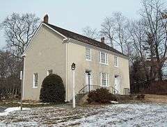
Glenwood is an unincorporated community in Howard County, Maryland, United States.[1] It is located between Baltimore and Washington, D.C., therefore attracting commuters to those employment centers. The community features acres of open space and is districted to Bushy Park Elementary, Glenwood and Folly Quarter Middle, and Glenelg High schools. Union Chapel was listed on the National Register of Historic Places in 1975 and Round About Hills was added in 2008.[2]
The area was settled in the early 18th century by the Ridgley and Warfield families forming large tobacco plantations "Bushy Park", "Longwood", "Ellerslie" and others. In 1822 James B. Matthews purchased a 200-acre farm and stone home from Caleb Dorsey. He opened a post office, on July 30, 1841 giving the area the name "Matthews Store" in the Howard District of Anne Arundel County, which operated until January 1874.[3][4] The Union Chapel was built in 1833. The Anne Arundel community became part of the newly formed Howard County. Despite southern sympathies, the Civil war ended slave labor on the local farms, slavery was replaced with Jim Crow laws. The Phrenakosmian Hall was opened, renamed to the Howard Institute serving 25 children. On January 13, 1874 the Glenwood postal stop opened.[3] It was renamed to Glenwood by James Matthew's son, Professor Lycurgus Matthews.[5][6]
In 1995, Glenwood land developer Randolph Ayersman made national news after police found that profits from drug sales were being used to buy and develop properties under A&A contracting in Glenwood.[7][8]
See also
References
- ↑ "Geographic Names Information System". Glenwood (Populated Place). U.S. Geological Survey. 2009-01-29.
- ↑ National Park Service (2008-04-15). "National Register Information System". National Register of Historic Places. National Park Service.
- 1 2 "Checklist of Maryland Post Offices" (PDF). Smithsonian National Postal Museum. 12 July 2007. Archived from the original (PDF) on August 15, 2013. Retrieved 17 May 2014.
- ↑ Baltimore Sun. 16 August 1841. p. 2. Missing or empty
|title=(help) - ↑ "Bloomsberg". Retrieved 5 April 2014.
- ↑ Howard County Historical Society. Images of America, Howard County. p. 28.
- ↑ "CRIME AND JUSTICE: Developer Accused Of Money Laundering". The Washington Psot. 12 August 1995.
- ↑ "An Upwardly Mobile Md. Marijuana Ring's Business Goes Bust". The Washington Post. 29 June 1995.
Municipalities and communities of Howard County, Maryland, United States | ||
|---|---|---|
| CDPs | 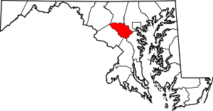 | |
| Villages | ||
| Unincorporated communities |
| |
| Footnotes | ‡This populated place also has portions in an adjacent county or counties | |
Coordinates: 39°17′15″N 77°01′41″W / 39.28750°N 77.02806°W