Jessup, Maryland
| Jessup, Maryland | |
|---|---|
| Census-designated place | |
|
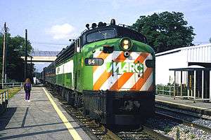
A MARC train at Jessup in June 1994. | |
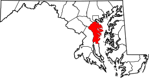
 Location of Jessup, Maryland in Anne Arundel County | |
| Coordinates: 39°8′18″N 76°46′30″W / 39.13833°N 76.77500°WCoordinates: 39°8′18″N 76°46′30″W / 39.13833°N 76.77500°W | |
| Country |
|
| State |
|
| Counties |
|
| Established | 1863 |
| Founded by | Jonathan Jessup |
| Area | |
| • Total | 5.3 sq mi (13.6 km2) |
| • Land | 5.3 sq mi (13.6 km2) |
| • Water | 0.0 sq mi (0.0 km2) |
| Elevation | 217 ft (66 m) |
| Population (2010) | |
| • Total | 7,137 |
| • Density | 1,358/sq mi (524.5/km2) |
| Time zone | Eastern (EST) (UTC-5) |
| • Summer (DST) | EDT (UTC-4) |
| ZIP code | 20794 |
| Area code(s) | 240, 301, 410, 443 |
| FIPS code | 24-42550 |
| GNIS feature ID | 0590560 |
Jessup (pronounced JES-əp) is an unincorporated community and census-designated place in Howard County, Maryland and Anne Arundel County, Maryland, United States. The population was 7,137 at the 2010 census.[1]
Geography
Jessup is located at 39°08′18″N 76°46′30″W / 39.138374°N 76.774929°W (39.138374, -76.774929).[2] According to the United States Census Bureau, the CDP has a total area of 5.3 square miles (13.6 km2), all of it land. As of the 2010 census, the center of population for the state of Maryland is located on the grounds of the Clifton T. Perkins Hospital Center in Jessup.[3][4]
History
Jessup is located near the site of the historic Spurrier's Tavern, a farm and tavern located on the post road between Baltimore and Washington (Route One) where George Washington travelled regularly.[5]
The location of the town was named Pierceland on early maps,[6] but the post-civil war name more commonly given was Jessup's Cut, or Jessop's Cut, a post village in Howard County on the Baltimore and Ohio Railroad. The name is generally attributed to Jonathan Jessup, a civil engineer who worked on the Baltimore and Ohio Railroad and the hand-dug "cut" though Merrill's Ridge he managed as a project. The name was shortened in 1863. Into the mid 20th century, the town was called "Jessups", then was shortened to "Jessup".[7]
Since the mid-19th century, the area has been home to various penal institutions.[8][9] Inmates today still refer to these jails as "the cut," probably unaware of the origin of the name. The Maryland House of Correction, operated by the Maryland Department of Corrections, included a large onsite farm manned with prison labor to provide food for prisoners onsite and offsite. Prisoner labor was discouraged by job seekers in the 1970s much as it did 100 years earlier during the construction of the B&O at Jessup's cut. The State-run Maryland Food Center occupies the land.[10] The prison closed to inmates in 2007.[11] The prison is referred to several times in the NBC television series Homicide: Life on the Street and the HBO original series, The Wire. Even though the maximum security prison is now closed, the town still houses a major minimum security prison, Brockbridge Correctional Facility, for violent offenders who are not deemed a threat to society due to the nature of their crimes.[12]
Jessup contains many warehouse delivery facilities. Due to its geographically central location in the state, Jessup is also home to the Maryland Food Center, which includes the Maryland Produce Market and the Maryland Seafood Market.[13] The largest facility was operated by Giant Food, with a 60-acre (24 ha) 760,000 sq ft (71,000 m2) facility until September 2012. The company outsourced distribution to C&S Wholesale Grocers, relocating its operations to Pennsylvania.[14] In 2013, Coastal Sunbelt Produce announced plans to relocate its 900-employee facility out of state claiming the facility was unable expand to adjacent empty parcels. Howard County was unable to relocate the facility to the vacant state-run facility, or the vacant 760,000sqft Giant Food facility with an offer to gift state land intended for a transportation hub to the company. County Executive Ken Ulman brokered a deal with Preston Scheffenacker Properties, rezoning the historic Duvall Farm site in Laurel, for light industrial use and issued county financed low interest loans to relocate the facility out of Jessup.[15]
Kingdon Gould's Laurel Sand and Gravel company, which includes Savage Stone, Fairfax Materials, Allegany Aggregates, Laurel Asphalt, and S.W. Barrick & Sons, purchased the 625-acre chase property in Eastern Jessup, North of the historic town of Savage, Maryland. The site is home to the Savage Stone quarry, mining Baltimore Gabbro rock for road bed construction. The facility started operations in 2005 after special zoning approval with a 25-year reserve in materials. Ridgley's Run Community Association directors Kingdon Gould and his son provided community approval of the project in exchange for the construction of the Ridgley's Run Community Center.[16][17][18]
To the north of the quarry, Orson Adams built two nineteenth-century Victorian Manor Houses named Oak Hill on a 235-acre estate that anchored the community. The homes burned down after the Rouse Company purchased the land, and have been redeveloped into apartments.[19]
Resident film maker Wayne Shipley used Jessup as the production location for One-Eyed Horse (2008) and Day of the Gun (2013).[20][21][22][23] Portions of Cry-Baby (1990) and Die Hard with a Vengeance (1995) were filmed in Jessup.
Neighborhoods
Major neighborhoods of Jessup include:
- Jessup, community surrounding Jessup station in Anne Arundel County.
- Guilford, located at the intersection of US 1 and Guilford Road.
- Waterloo, located at the intersection of US 1 and Waterloo Road.
Notable people
- Arnold Elzey, a major general in the Confederate army during the Civil War; he retired to a small farm near Jessup.
Demographics
As of the census[24] of 2000, there were 7,865 people, 379 households, and 280 families residing in the CDP. The population density was 1,858.0 people per square mile (717.9/km2). There were 398 housing units at an average density of 94.0/sq mi (36.3/km2). The racial makeup of the CDP was 67.73% African American, 31.28% White, 1.03% Hispanic or Latino, 0.33% Asian, 0.27% from other races, 0.22% from two or more races, 0.15% Native American, and 0.03% Pacific Islander.
There were 379 households out of which 29.6% had children under the age of 18 living with them, 57.5% were married couples living together, 9.5% had a female householder with no husband present, and 26.1% were non-families. 20.1% of all households were made up of individuals and 6.1% had someone living alone who was 65 years of age or older. The average household size was 2.68 and the average family size was 3.04.
In the CDP the population was spread out with 3.2% under the age of 18, 15.9% from 18 to 24, 62.5% from 25 to 44, 16.3% from 45 to 64, and 2.0% who were 65 years of age or older. The median age was 34 years. For every 100 females there were 499.9 males. For every 100 females age 18 and over, there were 539.7 males.
The median income for a household in the CDP was $48,000, and the median income for a family was $55,139. Males had a median income of $26,003 versus $24,950 for females. The per capita income for the CDP was $19,052. About 5.0% of families and 7.1% of the population were below the poverty line, including 7.1% of those under age 18 and 4.7% of those age 65 or over.
Transportation
The Jessup stop on the Camden Line of the MARC Train system provides commuter rail service.
Government
The Federal Bureau of Prisons operates the Mid-Atlantic Region Office in Jessup and in Anne Arundel County.[25][26] The Clifton T. Perkins Hospital Center, built in 1960, is a Maryland State-run maximum security hospital for criminals that are not guilty by reasons of insanity.[27]
References
- ↑ "Geographic Identifiers: 2010 Demographic Profile Data (G001): Jessup CDP, Maryland". U.S. Census Bureau, American Factfinder. Retrieved May 30, 2013.
- ↑ "US Gazetteer files: 2010, 2000, and 1990". United States Census Bureau. 2011-02-12. Retrieved 2011-04-23.
- ↑ "Center of Population – 2010 Census". Retrieved August 17, 2013.
- ↑ "State Centers of Population 1880–2010: Maryland". Retrieved August 17, 2013.
- ↑ Barbara Feaga. Howard's Roads to the Past. p. 66.
- ↑ Barbara W Feaga. Howard's Roads to the Past. p. 66.
- ↑ "History of Jessup". Jessup Improvement Association. Retrieved 2008-06-25.]
- ↑ Helderman, Rosalind M. (2007-03-19). "In Surprise Move, Md. Closes Jessup Prison, Transfers Inmates". The Washington Post. The Washington Post Company. Retrieved 2008-06-25.
- ↑ "Correctional Facility Locator". Maryland Department of Public Safety & Correctional Services. Retrieved 2008-06-25.
- ↑ Barbara Feaga. Howard's Roads to the Past. p. 67.
- ↑ Helderman, Rosalind S. "In Surprise Move, Md. Closes Jessup Prison, Transfers Inmates." The Washington Post. Monday March 19, 2007. Retrieved on January 1, 2010.
- ↑ "Brockbridge Correctional Facility". Maryland Department of Public Safety and Correctional Services. Retrieved August 17, 2013.
- ↑ "Maryland Food Center Authority". Retrieved August 17, 2013.
- ↑ Lorraine Mirabella (September 24, 2012). "Giant Food puts Jessup warehouse on the market; Dry goods distribution center shut down over summer; Trucks are parked in the lot of the Jessup dry goods warehouse". The Baltimore Sun.
- ↑ Amanda Yeager (January 28, 2014). Zoning change would help Coastal Sunbelt stay in Howard County. Missing or empty
|title=(help) - ↑ "Residents OK quarry in Jessup". The Baltimore Sun. June 3, 1994.
- ↑ "Savage quarry quandary Howard County: Hazardous quarry poses tough questions for county officials". The Baltimore Sun. 26 September 1995.
- ↑ "Construction Equipment Guide". Retrieved 10 April 2014.
- ↑ Adams Family of "Oak Hill" Howard County, Maryland. 1951.
- ↑ Johnson, Mary (December 28, 2007). "Retired teacher living dream of a Western". Baltimore Sun. Retrieved January 11, 2014.
Shipley set his historical epic on the family's 38-acre farm in Jessup.
- ↑ Read, Zoe (November 22, 2013). "Saddle up: Jessup filmmaker back with 'Day of the Gun'". Maryland Gazette. Retrieved January 10, 2014.
Shipley and his team started work on the film in 2010, and shot on his family farm for 23 days over a two-year period.
- ↑ "One Eyed Horse". IMDB. Retrieved January 8, 2013.
- ↑ "Day of the Gun". IMDB. Retrieved January 8, 2013.
- ↑ "American FactFinder". United States Census Bureau. Retrieved 2008-01-31.
- ↑ "Mid-Atlantic Region Office." Federal Bureau of Prisons. Retrieved on January 1, 2010.
- ↑ "Jessup CDP, Maryland." U.S. Census Bureau. Retrieved on January 1, 2010.
- ↑ Earl Arnett; Robert J. Brugger; Edward C. Papenfuse (March 22, 1999). Maryland: A New Guide to the Old Line State (2nd ed.). Johns Hopkins University Press. p. 388. ISBN 978-0801859809.
External links
 |
Oakland Mills | Owen Brown | Dorsey |
| |||
| |
|||||||
| Savage | |
Hanover | |||||
| |
|||||||
| North Laurel | Annapolis Junction | Fort Meade |
Municipalities and communities of Howard County, Maryland, United States | ||
|---|---|---|
| CDPs | 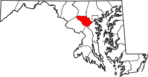 | |
| Villages | ||
| Unincorporated communities |
| |
| Footnotes | ‡This populated place also has portions in an adjacent county or counties | |