Clarksville, Maryland
| Clarksville, Maryland | |
|---|---|
| Unincorporated community | |
|
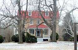
Montrose Manor in Clarksville. | |
| Country |
|
| State |
|
| County |
|
| Founded | July 4, 1851 |
| Founded by | William Clark |
| Government | |
| • County Councilwoman |
Mary Kay Sigaty District 4 |
| Time zone | Eastern (EST) (UTC-5) |
| • Summer (DST) | EDT (UTC-4) |
| ZIP | 21029 |
| Area code(s) | 410 & 443 |
Clarksville is an unincorporated community in Howard County; the second wealthiest county in the United States according to the U.S. Census Bureau.[1] The community is named for William Clark, a farmer who owned much of the land on which the community now lies and served as a postal stop that opened on the 4th of July 1851.[2][3]
Some of the most expensive homes on the East Coast are located in or around the town, whose property values are among the highest in the country. According to the U.S. Census Bureau, Clarksville District 5 has a population of 56,239, with an estimated average income of $195,124, with median income of $160,606.
The village of River Hill (which include Pheasant Ridge and Pointers Run), the newest addition to the Rouse Company development of Columbia, is adjacent to Clarksville.
Clarksville's public schools, part of the Howard County public school system, are among the highest-ranked in the nation and often have significantly higher funding than competing private and charter schools.
The area is located southwest of Baltimore and north of Washington, D.C., and many residents of Clarksville commute to work in one of these two cities or their close-in suburbs.
Montrose and Richland Farm are listed on the National Register of Historic Places in 1973.[4]
History
In 1699, Thomas Browne, a Patuxent Ranger, ranged the river from the Snowden plantation to where Clarksville is sited.[5] The area was settled with tobacco plantations such as Folly Quarter and Hobbs Regulation with slave labor.[6] In 1838, Dr. William Watkins of Richland Manor proposed the "Howard District" of Anne Arundel County, which became Howard County in 1851.[7] Clarksville's name originates from John R. Clark's family who immigrated from Ireland to the Howard District of Anne Arundel County in 1790. The land he purchased included Jack Howard's blacksmith shop, one of the few African American operated blacksmith's in the county.[8] Clarksville postal office listed the population as just 65 in the 1930s with the key industry of agriculture and limestone mining. Numerous apple orchards were situated between Clarksville and Ashton.[9] In 1869 the town became the terminus of the ten mile Ellicott City and Clarksville turnpike built over the old Sandy Spring road, a ten-mile private toll road created in a time before county maintained roads which later became route 108.[10][11]
Schooling
Clarksville is perhaps best known for its highly successful high school, River Hill. The school made the 397th rank on Newsweek's Top 1,200 High School River Hill, opened in 1996. It has 1,652 students and ranks as one of the top schools in the state of Maryland. In 2005, River Hill had a 97.55% graduation rate, ranking the highest in Maryland. 86.3% of its students passed the HSA (High school Assessment). River Hill is also very successful in sports, capturing numerous state titles in many sports. The boys' soccer team has captured three of the last four class 3A state titles (losing in 2006 to rival Mount Hebron). In 2007 River Hill won five state championships in the fall: Football, Boys' and Girls' Soccer, and Boys' and Girls' Cross Country. In addition, Clarksville Middle School's Wind Ensemble attended the prestigious Midwest Clinic in 2009, being the first middle school from Maryland to perform there.
It is also the home of the world-renowned Team Rocket Zero Robotics team, a part of the River Hill High School computer science program.
Pop culture
Clarksville, MD was referenced in the Fox television show 24 as the target for surface missiles by terrorists in the seventh season episode having the original air date of April 13, 2009.
Climate
The climate in this area is characterized by hot, humid summers and generally mild to cool winters. According to the Köppen Climate Classification system, Clarksville has a humid subtropical climate, abbreviated "Cfa" on climate maps.[12]
See also
- Clifton (Clarksville, Maryland) – a 1818 stone home built on the "White Wine & Claret" farm of John Dorsey
- Worthington's Range
- Montrose
- Richland Farm
- Walnut Grove
References
- ↑ U.S. Geological Survey Geographic Names Information System: Clarksville (Populated Place)
- ↑ A Gazetteer of Maryland: 24. 1901. Missing or empty
|title=(help) - ↑ "Checklist of Maryland Post Offices" (PDF). Smithsonian National Postal Museum. Archived from the original (PDF) on 18 May 2014. Retrieved 17 May 2014.
- ↑ National Park Service (2008-04-15). "National Register Information System". National Register of Historic Places. National Park Service.
- ↑ Howards Roads to the Past. p. 2.
- ↑ Seeking Freedom The History of the Underground Railroad in Howard County. p. 54.
- ↑ Howard's Roads to the Past. p. 2.
- ↑ Alice Cornelison; Silas E. Craft Sr.; Lillie Price. History of Blacks In Howard County. p. 47.
- ↑ Writers' Program of the Work Projects Administration in the State of Maryland. Maryland: A Guide to the Old Line State. p. 317.
- ↑ Maryland Geological Survey. Report on the Highways of Maryland, Volume 1. p. 261.
- ↑ Celia M. Holland. Old homes and families of Howard County, Maryland: with consideration of various additional points of interest. p. 324.
- ↑ Climate Summary for Clarksville, Maryland
Municipalities and communities of Howard County, Maryland, United States | ||
|---|---|---|
| CDPs | 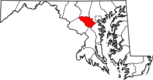 | |
| Villages | ||
| Unincorporated communities |
| |
| Footnotes | ‡This populated place also has portions in an adjacent county or counties | |
Coordinates: 39°12′23″N 76°56′35″W / 39.20639°N 76.94306°W