Glendale, Missouri
| Glendale, Missouri | |
|---|---|
| City | |
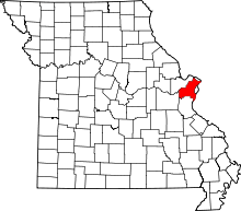
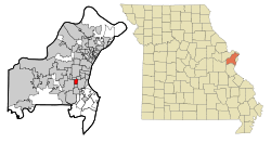 Location of Glendale, Missouri | |
| Coordinates: 38°35′35″N 90°23′3″W / 38.59306°N 90.38417°WCoordinates: 38°35′35″N 90°23′3″W / 38.59306°N 90.38417°W | |
| Country | United States |
| State | Missouri |
| County | St. Louis |
| Area[1] | |
| • Total | 1.29 sq mi (3.34 km2) |
| • Land | 1.29 sq mi (3.34 km2) |
| • Water | 0 sq mi (0 km2) |
| Elevation | 587 ft (179 m) |
| Population (2010)[2] | |
| • Total | 5,925 |
| • Estimate (2012[3]) | 5,920 |
| • Density | 4,593.0/sq mi (1,773.4/km2) |
| Time zone | Central (CST) (UTC-6) |
| • Summer (DST) | CDT (UTC-5) |
| Area code(s) | 314 |
| FIPS code | 29-27334[4] |
| GNIS feature ID | 0756107[5] |
Glendale is a city in St. Louis County, Missouri, United States. The population was 5,925 at the 2010 census.[6]
History
Glendale was voted the best place to live in Missouri in 2014 by movoto.com,[7] and was named from the scenic dales or glens in the region.[8]
Geography
Glendale is located at 38°35′35″N 90°23′3″W / 38.59306°N 90.38417°W (38.593052, −90.384191).[9]
According to the United States Census Bureau, the city has a total area of 1.29 square miles (3.34 km2), all of it land.[1]
Demographics
| Historical population | |||
|---|---|---|---|
| Census | Pop. | %± | |
| 1920 | 749 | — | |
| 1930 | 1,451 | 93.7% | |
| 1940 | 2,526 | 74.1% | |
| 1950 | 4,930 | 95.2% | |
| 1960 | 7,048 | 43.0% | |
| 1970 | 6,981 | −1.0% | |
| 1980 | 6,035 | −13.6% | |
| 1990 | 5,945 | −1.5% | |
| 2000 | 5,767 | −3.0% | |
| 2010 | 5,925 | 2.7% | |
| Est. 2015 | 5,927 | [10] | 0.0% |
2010 census
As of the census[2] of 2010, there were 5,925 people, 2,273 households, and 1,686 families residing in the city. The population density was 4,593.0 inhabitants per square mile (1,773.4/km2). There were 2,348 housing units at an average density of 1,820.2 per square mile (702.8/km2). The racial makeup of the city was 96.7% White, 0.7% African American, 0.9% Asian, 0.4% from other races, and 1.1% from two or more races. Hispanic or Latino of any race were 1.6% of the population.
There were 2,273 households, of which 38.6% had children under the age of 18 living with them, 65.2% were married couples living together, 7.4% had a female householder with no husband present, 1.6% had a male householder with no wife present, and 25.8% were non-families. 23.5% of all households were made up of individuals, and 10.2% had someone living alone who was 65 years of age or older. The average household size was 2.61 and the average family size was 3.11.
The median age in the city was 40.5 years. 29.2% of residents were under the age of 18; 4% were between the ages of 18 and 24; 23.7% were from 25 to 44; 29.3% were from 45 to 64; and 13.8% were 65 years of age or older. The gender makeup of the city was 46.2% male and 53.8% female.
2000 census
As of the census[4] of 2000, there were 5,767 people, 2,294 households, and 1,640 families residing in the city. The population density was 4,474.6 people per square mile (1,726.1/km²). There were 2,339 housing units at an average density of 1,814.8 per square mile (700.1/km²). The racial makeup of the city was 97.61% White, 0.88% African American, 0.03% Native American, 0.55% Asian, 0.31% from other races, and 0.61% from two or more races. Hispanic or Latino of any race were 1.13% of the population.
There were 2,294 households, out of which 35.7% had children under the age of 18 living with them, 62.6% were married couples living together, 7.4% had a female householder with no husband present, and 28.5% were non-families. 26.0% of all households were made up of individuals, and 11.6% had someone living alone who was 65 years of age or older. The average household size was 2.51 and the average family size was 3.06.
In the city the population was spread out, with 27.7% under the age of 18, 3.7% from 18 to 24, 28.3% from 25 to 44, 25.9% from 45 to 64, and 14.5% who were 65 years of age or older. The median age was 40 years. For every 100 females there were 88.6 males. For every 100 females age 18 and over, there were 83.1 males.
The median income for a household in the city was $75,279, and the median income for a family was $90,250. Males had a median income of $70,018 versus $36,552 for females. The per capita income for the city was $35,136. About 0.4% of families and 0.4% of the population were below the poverty line, including 0.3% of those under age 18 and none of those age 65 or over.[12]
Mayor
Richard J. Magee was appointed to the Board of Aldermen representing Ward III in February 1995. He was then elected to this seat and sworn into office on May 6, 1996 and continued to be re-elected to serve in this capacity until he was elected mayor and sworn into office on May 2, 2005. He was re-elected to a fourth term as mayor April 5, 2011. Magee is an attorney and a partner with the Eckenrode-Maupin Law Firm.
References
- 1 2 "US Gazetteer files 2010". United States Census Bureau. Archived from the original on January 24, 2012. Retrieved 2012-07-08.
- 1 2 "American FactFinder". United States Census Bureau. Retrieved 2012-07-08.
- ↑ "Population Estimates". United States Census Bureau. Archived from the original on June 17, 2013. Retrieved 2013-05-30.
- 1 2 "American FactFinder". United States Census Bureau. Retrieved 2008-01-31.
- ↑ "US Board on Geographic Names". United States Geological Survey. 2007-10-25. Retrieved 2008-01-31.
- ↑ "Race, Hispanic or Latino, Age, and Housing Occupancy: 2010 Census Redistricting Data (Public Law 94-171) Summary File (QT-PL), Glendale city, Missouri". U.S. Census Bureau, American FactFinder 2. Retrieved October 21, 2011.
- ↑ Randy Nelson. "These Are the 10 Best Places in Missouri" (blog). Moveto.
- ↑ Eaton, David Wolfe (1918). How Missouri Counties, Towns and Streams Were Named. The State Historical Society of Missouri. p. 360.
- ↑ "US Gazetteer files: 2010, 2000, and 1990". United States Census Bureau. 2011-02-12. Retrieved 2011-04-23.
- ↑ "Annual Estimates of the Resident Population for Incorporated Places: April 1, 2010 to July 1, 2015". Retrieved July 2, 2016.
- ↑ "Census of Population and Housing". Census.gov. Archived from the original on May 11, 2015. Retrieved June 4, 2015.
- ↑ "City of Glendale MO". City of Glendale. Retrieved 20 May 2012.