Crystal Lake Park, Missouri
| Crystal Lake Park, Missouri | |
|---|---|
| City | |
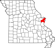
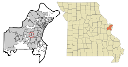 Location of Crystal Lake Park, Missouri | |
| Coordinates: 38°37′12″N 90°25′56″W / 38.62000°N 90.43222°WCoordinates: 38°37′12″N 90°25′56″W / 38.62000°N 90.43222°W | |
| Country | United States |
| State | Missouri |
| County | St. Louis |
| Village of Crystal Lake Park & City of Crystal Lake Park | 1938 & 1957 |
| Named for | Crystal Lake Country Club (no longer exists) |
| Government | |
| • Mayor | Phillip Brant |
| • Alderperson | Susan Kusama |
| • Alderperson | Chris Sanders |
| • Alderperson | Dennis Nahnsen |
| • Alderperson | CarolAnn Giovando |
| Area[1] | |
| • Total | 0.11 sq mi (0.28 km2) |
| • Land | 0.11 sq mi (0.28 km2) |
| • Water | 0 sq mi (0 km2) |
| Elevation | 607 ft (185 m) |
| Population (2010)[2] | |
| • Total | 470 |
| • Estimate (2012[3]) | 475 |
| • Density | 4,272.7/sq mi (1,649.7/km2) |
| Time zone | Central (CST) (UTC-6) |
| • Summer (DST) | CDT (UTC-5) |
| Zip code | 63131 |
| Area code(s) | 314 |
| FIPS code | 29-17650[4] |
| GNIS feature ID | 0755955[5] |
Crystal Lake Park is a Missouri Class 4 city in St. Louis County, Missouri, United States. The population was 470 at the 2010 census.[6]
Geography
Crystal Lake Park is located at 38°37′12″N 90°25′56″W / 38.62000°N 90.43222°W (38.619989, -90.432321).[7]
According to the United States Census Bureau, the city has a total area of 0.11 square miles (0.28 km2), all of it land.[1]
Demographics
| Historical population | |||
|---|---|---|---|
| Census | Pop. | %± | |
| 1940 | 95 | — | |
| 1950 | 167 | 75.8% | |
| 1960 | 307 | 83.8% | |
| 1970 | 356 | 16.0% | |
| 1980 | 496 | 39.3% | |
| 1990 | 506 | 2.0% | |
| 2000 | 457 | −9.7% | |
| 2010 | 470 | 2.8% | |
| Est. 2015 | 499 | [8] | 6.2% |
2010 census
As of the census[2] of 2010, there were 470 people, 202 households, and 136 families residing in the city. The population density was 4,272.7 inhabitants per square mile (1,649.7/km2). There were 222 housing units at an average density of 2,018.2 per square mile (779.2/km2). The racial makeup of the city was 91.5% White, 2.8% African American, 4.7% Asian, 0.2% from other races, and 0.9% from two or more races. Hispanic or Latino of any race were 1.5% of the population.
There were 202 households of which 29.7% had children under the age of 18 living with them, 57.9% were married couples living together, 7.4% had a female householder with no husband present, 2.0% had a male householder with no wife present, and 32.7% were non-families. 29.2% of all households were made up of individuals and 16.9% had someone living alone who was 65 years of age or older. The average household size was 2.33 and the average family size was 2.91.
The median age in the city was 47.9 years. 25.3% of residents were under the age of 18; 2.4% were between the ages of 18 and 24; 16.8% were from 25 to 44; 34.4% were from 45 to 64; and 21.1% were 65 years of age or older. The gender makeup of the city was 44.9% male and 55.1% female.
2000 census
As of the census[4] of 2000, there were 457 people, 204 households, and 136 families residing in the city. The population density was 4,787.5 people per square mile (1,764.5/km²). There were 221 housing units at an average density of 2,315.2 per square mile (853.3/km²). The racial makeup of the city was 96.72% White, 0.22% Native American, 0.66% Asian, 0.22% Pacific Islander, 0.66% from other races, and 1.53% from two or more races. Hispanic or Latino of any race were 1.31% of the population.
There were 204 households out of which 28.9% had children under the age of 18 living with them, 58.8% were married couples living together, 5.4% had a female householder with no husband present, and 33.3% were non-families. 30.4% of all households were made up of individuals and 14.2% had someone living alone who was 65 years of age or older. The average household size was 2.24 and the average family size was 2.80.
In the city the population was spread out with 21.7% under the age of 18, 3.5% from 18 to 24, 21.0% from 25 to 44, 30.4% from 45 to 64, and 23.4% who were 65 years of age or older. The median age was 47 years. For every 100 females there were 87.3 males. For every 100 females age 18 and over, there were 82.7 males.
The median income for a household in the city was $78,441, and the median income for a family was $91,765. Males had a median income of $61,875 versus $44,375 for females. The per capita income for the city was $55,596. About 2.3% of families and 3.1% of the population were below the poverty line, including 3.1% of those under age 18 and 2.6% of those age 65 or over.
References
- 1 2 "US Gazetteer files 2010". United States Census Bureau. Archived from the original on 2012-01-24. Retrieved 2012-07-08.
- 1 2 "American FactFinder". United States Census Bureau. Retrieved 2012-07-08.
- ↑ "Population Estimates". United States Census Bureau. Archived from the original on 2013-06-17. Retrieved 2013-05-30.
- 1 2 "American FactFinder". United States Census Bureau. Archived from the original on 2013-09-11. Retrieved 2008-01-31.
- ↑ "US Board on Geographic Names". United States Geological Survey. 2007-10-25. Retrieved 2008-01-31.
- ↑ "Race, Hispanic or Latino, Age, and Housing Occupancy: 2010 Census Redistricting Data (Public Law 94-171) Summary File (QT-PL), Crystal Lake Park city, Missouri". U.S. Census Bureau, American FactFinder 2. Archived from the original on September 11, 2013. Retrieved October 19, 2011.
- ↑ "US Gazetteer files: 2010, 2000, and 1990". United States Census Bureau. 2011-02-12. Retrieved 2011-04-23.
- ↑ "Annual Estimates of the Resident Population for Incorporated Places: April 1, 2010 to July 1, 2015". Retrieved July 2, 2016.
- ↑ "Census of Population and Housing". Census.gov. Archived from the original on May 11, 2015. Retrieved June 4, 2015.
External links
- Crystal Lake Park official website
- "Crystal Lake Park photographs". University of Missouri–St. Louis.