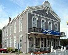
Manchester, Missouri
| Manchester, Missouri | |
|---|---|
| City | |
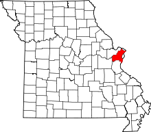
 Location of Manchester, Missouri | |
| Coordinates: 38°35′3″N 90°30′27″W / 38.58417°N 90.50750°WCoordinates: 38°35′3″N 90°30′27″W / 38.58417°N 90.50750°W | |
| Country | United States |
| State | Missouri |
| County | St. Louis |
| Area[1] | |
| • Total | 5.08 sq mi (13.16 km2) |
| • Land | 5.08 sq mi (13.16 km2) |
| • Water | 0 sq mi (0 km2) |
| Elevation | 577 ft (176 m) |
| Population (2010)[2] | |
| • Total | 18,094 |
| • Estimate (2012[3]) | 18,165 |
| • Density | 3,561.8/sq mi (1,375.2/km2) |
| Time zone | Central (CST) (UTC-6) |
| • Summer (DST) | CDT (UTC-5) |
| FIPS code | 29-45668[4] |
| GNIS feature ID | 0756342[5] |
Manchester is a city in St. Louis County, Missouri, United States. The population was 18,094 at the 2010 census.[6] The mayor is David Willson.
History
Manchester was named by an English settler after Manchester, England.[7]
Geography
Manchester is located at 38°35′3″N 90°30′27″W / 38.58417°N 90.50750°W (38.584244, -90.507449).[8]
According to the United States Census Bureau, the city has a total area of 5.08 square miles (13.16 km2), all of it land.[1]
Demographics
| Historical population | |||
|---|---|---|---|
| Census | Pop. | %± | |
| 1960 | 2,021 | — | |
| 1970 | 5,031 | 148.9% | |
| 1980 | 6,351 | 26.2% | |
| 1990 | 6,542 | 3.0% | |
| 2000 | 19,161 | 192.9% | |
| 2010 | 18,094 | −5.6% | |
| Est. 2015 | 18,229 | [9] | 0.7% |
2010 census
As of the census[2] of 2010, there were 18,094 people, 7,239 households, and 5,048 families residing in the city. The population density was 3,561.8 inhabitants per square mile (1,375.2/km2). There were 7,553 housing units at an average density of 1,486.8 per square mile (574.1/km2). The racial makeup of the city was 87.6% White, 3.1% African American, 0.2% Native American, 6.0% Asian, 1.1% from other races, and 2.1% from two or more races. Hispanic or Latino of any race were 2.9% of the population.
There were 7,239 households of which 32.4% had children under the age of 18 living with them, 57.7% were married couples living together, 8.7% had a female householder with no husband present, 3.3% had a male householder with no wife present, and 30.3% were non-families. 24.3% of all households were made up of individuals and 7.7% had someone living alone who was 65 years of age or older. The average household size was 2.50 and the average family size was 3.00.
The median age in the city was 38.9 years. 23.5% of residents were under the age of 18; 8% were between the ages of 18 and 24; 26.2% were from 25 to 44; 29.5% were from 45 to 64; and 12.9% were 65 years of age or older. The gender makeup of the city was 48.7% male and 51.3% female.
2000 census
As of the census[4] of 2000, there were 19,161 people, 7,206 households, and 5,332 families residing in the city. The population density was 3,834.6 people per square mile (1,479.6/km²). There were 7,402 housing units at an average density of 1,481.3 per square mile (571.6/km²). The racial makeup of the city was 91.60% White, 2.42% African American, 0.09% Native American, 4.33% Asian, 0.03% Pacific Islander, 0.40% from other races, and 1.13% from two or more races. Hispanic or Latino of any race were 1.52% of the population.
There were 7,206 households out of which 37.5% had children under the age of 18 living with them, 63.3% were married couples living together, 8.2% had a female householder with no husband present, and 26.0% were non-families. 20.6% of all households were made up of individuals and 5.4% had someone living alone who was 65 years of age or older. The average household size was 2.66 and the average family size was 3.12.
In the city the population was spread out with 27.2% under the age of 18, 7.5% from 18 to 24, 30.8% from 25 to 44, 25.5% from 45 to 64, and 9.0% who were 65 years of age or older. The median age was 36 years. For every 100 females there were 95.0 males. For every 100 females age 18 and over, there were 90.6 males.
The median income for a household in the city was $64,381, and the median income for a family was $71,329. Males had a median income of $50,783 versus $35,039 for females. The per capita income for the city was $27,663. About 1.5% of families and 3.0% of the population were below the poverty line, including 3.4% of those under age 18 and 1.1% of those age 65 or over.
Education
The Parkway School District has one high school located within the Manchester city limits: Parkway South High School. Two middle schools (South Middle and Southwest Middle) serve this high school area, and several elementary schools bring education to the neighborhood level.[11] Hanna Woods, Carman Trails, and Wren Hollow are some of the elementary schools in Manchester.
John F. Kennedy Catholic High School operates as an archdiocesan Catholic high school, off Missouri Highway 141.
The Grand Glaize Branch of St. Louis County Library is in Manchester.[12][13][14]
References
- 1 2 "US Gazetteer files 2010". United States Census Bureau. Retrieved 2012-07-08.
- 1 2 "American FactFinder". United States Census Bureau. Retrieved 2012-07-08.
- ↑ "Population Estimates". United States Census Bureau. Retrieved 2013-05-30.
- 1 2 "American FactFinder". United States Census Bureau. Retrieved 2008-01-31.
- ↑ "US Board on Geographic Names". United States Geological Survey. 2007-10-25. Retrieved 2008-01-31.
- ↑ "Race, Hispanic or Latino, Age, and Housing Occupancy: 2010 Census Redistricting Data (Public Law 94-171) Summary File (QT-PL), Manchester city, Missouri". U.S. Census Bureau, American FactFinder 2. Retrieved October 24, 2011.
- ↑ Eaton, David Wolfe (1918). How Missouri Counties, Towns and Streams Were Named. The State Historical Society of Missouri. p. 360.
- ↑ "US Gazetteer files: 2010, 2000, and 1990". United States Census Bureau. 2011-02-12. Retrieved 2011-04-23.
- ↑ "Annual Estimates of the Resident Population for Incorporated Places: April 1, 2010 to July 1, 2015". Retrieved July 2, 2016.
- ↑ "Census of Population and Housing". Census.gov. Retrieved June 4, 2015.
- ↑ "." Parkway School District Boundary Map. Retrieved on October 8, 2010.
- ↑ "Grand Glaize Branch." St. Louis County Library. Retrieved on August 18, 2009.
- ↑ "Manchester city, Missouri." U.S. Census Bureau. Retrieved on August 18, 2009.
- ↑ "2009 Street Guide." Village of Twin Oaks (Missouri). Retrieved on August 18, 2009.
External links
| Topics |  | |
|---|---|---|
| Central city | ||
| Largest cities (over 50,000 in 2010) | ||
| Medium-sized cities (over 20,000 in 2010) | ||
| Largest towns and villages (over 10,000 in 2010) |
| |
| Missouri Counties | ||
| Illinois Counties | ||
| Subregions | ||