Fort Independence (Massachusetts)
|
Fort Independence | |
 | |
  | |
| Location | Castle Island, Boston, Massachusetts |
|---|---|
| Coordinates | 42°20′17″N 71°0′42″W / 42.33806°N 71.01167°WCoordinates: 42°20′17″N 71°0′42″W / 42.33806°N 71.01167°W |
| Area | 15 acres (6.1 ha) |
| Built | 1634 |
| NRHP Reference # | 70000921[1] |
| Added to NRHP | October 15, 1970 |
Fort Independence is a granite star fort that provided harbor defenses for Boston, Massachusetts. Located on Castle Island, Fort Independence is one of the oldest continuously fortified sites of English origin in the United States.[2][3] The first primitive fortification was placed on the site in 1634 and replaced in 1701 with a more substantial structure known as Castle William. Re-built after it was abandoned by the British during the American Revolution, Castle William was renamed Fort Adams and then Fort Independence. The existing granite fort was constructed between 1833 and 1851. Today it is preserved as a state park and fires occasional ceremonial salutes. Fort Independence was added to the National Register of Historic Places in 1970.[4]
History
Castle William

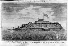
The site of Fort Independence has been occupied by various fortifications since 1634.[6] The first fort to be constructed on Castle Island was planned and supervised by Deputy Gov. Roger Ludlow and Captain John Mason of Dorchester, an earthen fort in which cannon were mounted to defend the colonial town of Boston from attack by sea. The first commander of the fort was Captain Nicholas Simpkins in 1634. (This information in taken from his biography and from the town history of Yarmouth, MA.) The first fort soon fell into disrepair and was rebuilt, mainly out of timber, in the 1640s. At this time the fort mounted six saker cannons and three smaller guns.[7] A later commander of the fort was Captain Richard Davenport, who supervised the post from 1645 until 1665 when he was struck by lightning within the fort and killed.[8] His successor, Captain Roger Clap, commanded the fort from 1665–1686.[7] The timber fort was taken down and a new fort of brick was built in its place in 1701.[9] The new fort was designed by Wolfgang William Romer, the chief engineer of British forces in the American colonies.[10] The earlier incarnations of the fort were simply known as "the Castle"; however, the larger 1701 fort was called "Castle William" in honor of King William III of England.[6]
In the years leading up to the American Revolution, Castle William became a refuge for British officials during periods of unrest and rioting in Boston. Violence in the wake of events such as the Stamp Act crisis in 1765 and the Boston Massacre in 1770 forced provincial leaders and British soldiers to take shelter within the fort.[6]
As the American Revolution erupted in 1775, American forces quickly commenced the Siege of Boston and British forces made Castle William their primary stronghold. It was not until the Continental Army led by George Washington managed the fortification of Dorchester Heights that Castle William was threatened and the British evacuated Boston in March 1776. Before leaving Castle William, the British set fire to the fort and destroyed it.[11]
Fort Adams
After it was evacuated, the fort was quickly re-built by American forces in 1776. Although still referred to, at times, as Castle William, the fort was officially known as Fort Adams in the years following the Revolution. In 1785, the legislature of Massachusetts designated the fort as a prison, in which capacity it served until 1805.[12]
On December 7, 1797, the fort was renamed Fort Independence during a ceremony attended by President John Adams. The following year, the fortification and the island were turned over to the United States government.[12] The fort was rebuilt and expanded in 1800-1803 under the first system of US fortifications (some sources place it in the second system).[13][14] The Secretary of War's report on fortifications for December 1811 describes the fort as "...a regular pentagon, with bastions of masonry, mounting 42 heavy cannon, with two [additional] batteries for six guns...".[15] During the War of 1812, a squadron of the British navy repeatedly captured American merchant and fishing vessels in Massachusetts Bay, however they never attempted an attack on the port of Boston owing largely to the strength of Fort Independence.[16] Colonel John Breck, namesake of Brecksville, Ohio, was the Commandant of Fort Independence during the War of 1812
Existing structure
Work on the present fort began in 1833 under the third system of US fortifications and was supervised by Colonel Sylvanus Thayer, one of the nation's leading military engineers of the time. The new fort would have walls 30 feet (9.1 m) high and 5.5 feet (1.7 m) thick. It was constructed primarily out of granite from Rockport, Massachusetts and completed in 1851. At the height of its strength during the American Civil War, the fort mounted 96 cannon, many of which were 15-inch Rodman guns capable of firing a 450-pound shot more than 3 miles (4.8 km).[17][18]
At the start of the Civil War in 1861, Fort Independence was garrisoned by the Fourth Battalion Massachusetts Volunteer Militia. The battalion set the fort in order and were trained in infantry and artillery drill, eventually forming the nucleus of the 24th Regiment Massachusetts Volunteer Infantry. At least two other infantry regiments were trained at Fort Independence during the Civil War—the 11th Massachusetts and the 13th Massachusetts.[19]
Following the Civil War, Fort Independence gradually fell out of use, as its importance was reduced by the larger Fort Warren which had also been constructed under the direction of Sylvanus Thayer. In the 1880s, landscape architect Frederick Law Olmsted designed a series of parkways and parks in Boston known as the Emerald Necklace. Olmsted had originally envisioned a parkway to be known as the Dorchesterway that would connect Castle Island (via a new earthen causeway) to the rest of the Emerald Necklace. The Dorchesterway was never realized, however the city of Boston did undertake a large scale project in the 1890s to create a park-like environment around Fort Independence. In 1890, Castle Island (excluding the fort) was ceded by the United States government. The city of Boston commenced filling the marshes separating Castle Island from South Boston in 1890 with the intention of creating green space and promenades. The process was finished in the 1920s and Castle Island ceased to be an island. The fort itself was ceded by the federal government to the city of Boston in 1908.[20]

In 1898, during the Spanish–American War, the U.S. government briefly reclaimed Castle Island, however it was quickly returned to the city of Boston in 1899. The military again took control of Fort Independence during World War I and World War II and anti-aircraft guns were added. During World War I, the fort was used primarily as a depot for small arms ammunition and during World War II, it was used by the United States Navy as a degaussing station for de-magnetizing the hulls of ships. At the close of both conflicts, the fort was promptly returned to the custody of the city of Boston.[21]
In 1962, the U.S. government permanently deeded Castle Island and Fort Independence to the Commonwealth of Massachusetts.[20] It is now overseen by the Massachusetts Department of Conservation and Recreation and the non-profit Castle Island Association. Over the course of its history, a shot was never fired in anger from Fort Independence by United States forces.[2]
Edgar Allan Poe
A persistent, though mostly apocryphal, story involving Fort Independence was allegedly the inspiration behind one of Edgar Allan Poe's most well known works. A monument outside the west battery of the fort marks the grave of Lieutenant Robert F. Massie, who was killed in a duel there on December 25, 1817. According to folklorist Edward Rowe Snow, Massie was so popular with the soldiers stationed at Fort Independence that they took out their frustration on his killer, Lieutenant Gustavus Drane, by walling him up within a vault in the fort. Edgar Allan Poe, while serving with the 1st United States Artillery Regiment at Fort Independence purportedly heard the tale and was inspired, according to Snow, to write The Cask of Amontillado.[22]
The legend that purportedly inspired Poe is not entirely accurate. The duel did in fact take place, but the victor, Lieutenant Drane, was not murdered by the fort's soldiers but continued in his military career and was later promoted to the rank of captain. After World War II, Lieutenant Massie's remains were moved to Fort Devens Cemetery in Ayer, Massachusetts.[23]
See also
Notes
- ↑ National Park Service (2009-03-13). "National Register Information System". National Register of Historic Places. National Park Service.
- 1 2 Wilson, 312.
- ↑ Fort Constitution at NorthAmericanForts.com
- ↑ Massachusetts Department of Conservation and Recreation
- ↑ Lossing, Benson (1868). The Pictorial Field-Book of the War of 1812. Harper & Brothers, Publishers. p. 236.
- 1 2 3 Wilson, 313.
- 1 2 Shurtleff, 478.
- ↑ Shurtleff, 490.
- ↑ Shurtleff, 492.
- ↑ Shurtleff, 493.
- ↑ Kales, 49.
- 1 2 Shurtleff, 495–496.
- ↑ Fort Independence at NorthAmericanForts.com
- ↑ Fort Independence at FortWiki.com
- ↑ Wade, Arthur P. (2011). Artillerists and Engineers: The Beginnings of American Seacoast Fortifications, 1794-1815. CDSG Press. p. 242. ISBN 978-0-9748167-2-2.
- ↑ Kales, 57.
- ↑ Wilson, 315.
- ↑ Weaver II, John R. (2001). A Legacy in Brick and Stone: American Coastal Defense Forts of the Third System, 1816-1867. McLean, VA: Redoubt Press. pp. 86–87. ISBN 1-57510-069-X.
- ↑ Kales, 76.
- 1 2 Seasholes, 326.
- ↑ Kales, 111 and 123.
- ↑ Wilson, 317.
- ↑ Historical Register and Dictionary of the United States Army 1789 - 1903, Heitman.
References
- Kales, David (2007). The Boston Harbor Islands: a History of Urban Wilderness. Charleston: The History Press. ISBN 978-1-59629-290-1.
- Seasholes, Nancy S. (2003). Gaining Ground: A History of Landmaking in Boston. Cambridge, Massachusetts: MIT Press. ISBN 0-262-19494-5.
- Shurtleff, Nathaniel Bradstreet (1871). A Topographical and Historical Description of Boston. Boston: Boston City Council. OCLC 4422090.
- Wilson, Susan (2004). Boston Sites and Insights : An Essential Guide to Historic Landmarks in and around Boston. Boston: Beacon Press. ISBN 0-8070-7135-8.
- "Castle Island, Pleasure Bay, M Street Beach and Carson Beach". Massachusetts Department of Conservation and Recreation. Retrieved 2007-07-15.
External links
| Wikimedia Commons has media related to Fort Independence (Massachusetts). |
- Castle Island Association website
- A 1781 view of the channel into Boston Harbor (see top panel) that looks northward, with Castle William on the left and Governors Island on the right.
| Topics |  | ||||||||||||||||||||||||||||||
|---|---|---|---|---|---|---|---|---|---|---|---|---|---|---|---|---|---|---|---|---|---|---|---|---|---|---|---|---|---|---|---|
| Lists by county | |||||||||||||||||||||||||||||||
| Lists by city |
| ||||||||||||||||||||||||||||||
| Other lists | |||||||||||||||||||||||||||||||
| |||||||||||||||||||||||||||||||
| Active |
|  | |||||||||||||||||||||||||||||||||||||||||||||||||||||||||||||||||||||||||||||||||||||||||||||||||||||||||||||||
|---|---|---|---|---|---|---|---|---|---|---|---|---|---|---|---|---|---|---|---|---|---|---|---|---|---|---|---|---|---|---|---|---|---|---|---|---|---|---|---|---|---|---|---|---|---|---|---|---|---|---|---|---|---|---|---|---|---|---|---|---|---|---|---|---|---|---|---|---|---|---|---|---|---|---|---|---|---|---|---|---|---|---|---|---|---|---|---|---|---|---|---|---|---|---|---|---|---|---|---|---|---|---|---|---|---|---|---|---|---|---|---|---|---|
| Inactive |
| ||||||||||||||||||||||||||||||||||||||||||||||||||||||||||||||||||||||||||||||||||||||||||||||||||||||||||||||||