Endeavour (crater)
 | |
| Planet | Mars |
|---|---|
| Region | Meridiani Planum |
| Coordinates | 2°17′S 5°14′W / 2.28°S 5.23°WCoordinates: 2°17′S 5°14′W / 2.28°S 5.23°W |
| Diameter | 22 kilometers (13.7 miles)[1] |
| Depth | 300 meters (1,000 feet)[2] |
| Eponym |
Endeavour, Saskatchewan, Canada (official name)[3]
|


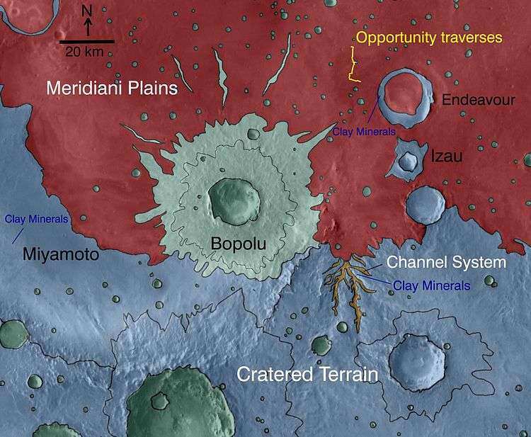
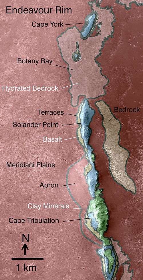
Endeavour is an impact crater located in the Meridiani Planum extraterrestrial plain within the Margaritifer Sinus quadrangle (MC-19) region of the planet Mars. Endeavour is about 22 kilometers (14 mi) in diameter.[1] Using Mars Reconnaissance Orbiter data, phyllosilicate-bearing outcrops have been detected along the rim of this crater. These minerals may have formed under wet conditions in a low-acidic environment during the early history of Mars.[5] There are raised rim segments to the north, east, and southwest. The rim has become worn, rounded and degraded, with infilling of plains material in a manner similar to the Victoria crater.[6]
When compared to the surrounding plains, the crater floor shows an enhanced spectral signature of basalt and hematite.[7] The interior contains two groups of dune fields. Images taken since 2008 show evidence of changes in some of the associated formations, which may be evidence of active erosion by the martian wind over a period of two to three years.[6] The plains surrounding the rim show evidence of polyhydrated sulfate.[7]
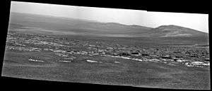
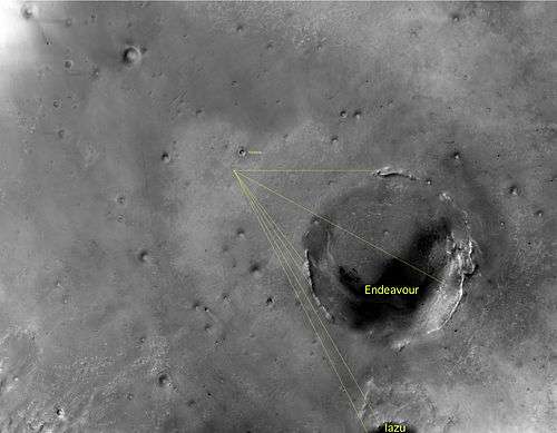
The Mars Exploration Rover-B Opportunity began travelling toward this crater in August 2008,[1] with the rim coming into sight on March 7, 2009,[8] and arriving at the edge on August 9, 2011.[9]
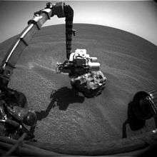
In December 2011, Opportunity Rover discovered a vein of gypsum sticking out of the soil along the rim of Endeavour crater. Tests confirmed that it contained calcium, sulfur, and water. The mineral gypsum is the best match for the data. It likely formed from mineral-rich water moving through a crack in the rock. The vein, called "Homestake," is in Mars' Meridiani plain. It could have been produced in conditions more neutral than the harshly acidic conditions indicated by the other sulfate deposits; hence this environment may have been more hospitable for a large variety of living organisms. Homestake is in a zone where the sulfate-rich sedimentary bedrock of the plains meets older, volcanic bedrock exposed at the rim of Endeavour crater.[10]
Nomenclature
The International Astronomical Union named the crater after a town in Canada.[3] The name was approved on 20 October 2008.[11] Due to rules for naming craters, it is officially named after the Canadian town, but the reason this name was proposed was because rover team was using informal nicknames based on a voyage of the HMS Endeavour.[4]
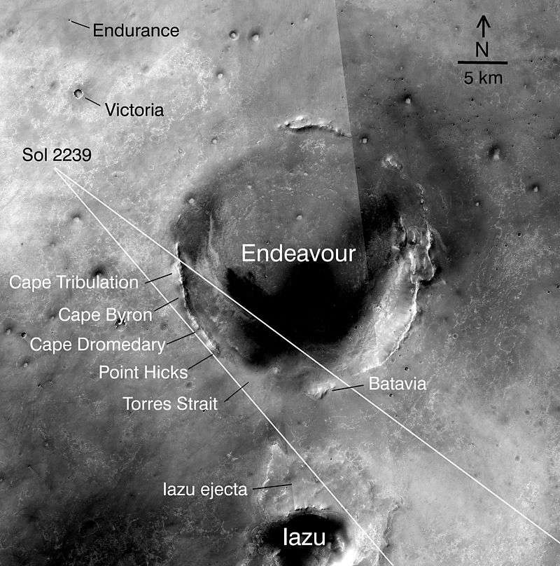
An informal working nickname by the Mars mission for the crater was Endeavour, and features of it, are based on the voyage of HM Bark Endeavour,[12] a British Royal Navy research vessel commanded by Lieutenant James Cook on his first voyage of discovery, to Fiji, New Zealand and Australia from 1769 to 1771, using Australian places named by James Cook. Examples include: Cape Dromedary, Point Hicks, Byron Bay, Cape Tribulation, Cape Byron, and Cape York.[13] The purpose of the voyage was to observe the transit of Venus, to accurately measure the distance to the Sun, then to explore lands found on the return journey.
Elevation map of surroundings
Endeavour crater averages about 200 to 300 meters deep, with an area in its southeast that goes down to 500 meters deep, according to publication called Degradation of Endeavour Crater, Mars by the Smithsonian Institute.[14] The south-west depression goes down to an elevation of minus minus 1980 meters, the horse-shoe shaped depression sits in the south-east quadrant and is around minus 1800 to 1900 meters elevation, which is about 400 meters below the surrounding plains.[14] It is noted that the crater has under-gone various erosion processes, with wind being one cause.[14]

Geology
The crater is understood by the 2010s to have two main rock types, the Shoemaker Formation and the Matijevic Formation.[16] It has been classified as a complex crater and it is thought to be so old many of its features have been worn away.[16] Some questions were raised about the tilt of the rim, however understanding is hampered by a lack of knowledge about Martian impact craters: Endeavour was the largest Martian impact crater up to that time to be studied that closely.[16] An example of the difficulty of studying Mars features is also apparent with Orcus Patera, which has various volcanic, tectonic, or cratering events explanations for its formation.[17] One famous Mars realization was that what was then called Nix Olympica was a volcano, and then renamed Olympus Mons thanks to Mariner 9 orbiter observations in the early 1970s.[18] Endeavour crater was identified as having clay minerals, as detected from orbit by Mars Reconnaissance Orbiter, which according to theories at that time indicated rock from an older, wetter, time period on Mars.[19] This type of rock is different from what prevails in other areas of surrounding plains.[19]
What is expected to be a fluid-carved gully was identified at Endeavour crater, probably water.[20] This gully is targeted for exploration by the MER-B rover mission as of October 2016.[20]
Mineral map of surrounding
Western rim

- Cape York (Mars), at the northern end of the Eastern rim[21]
- Sutherland Point[21]
- Nobby's Head, just below Cape York
- Botany Bay, an open area between Cape York and Solander Point
- Solander Point
- Murray Ridge
- Pilinger Point[14]
- Widowak Ridge[14]
- Ulysses crater [22]
- Cape Tribulation
- Marathon Valley
- Cape Bryon
- Cape Dromedary
- Point Hicks
- Torres Straight, marks the southern end of the Western rim
The next rim section proceeding counter-clockwise around the crater is Batavia, on the southern end of the whole crater but East of Torres Straight

Western rim mineral map
Western rim elevation

Western rim sections from Solander to Marathon
3492 (November 2013)

3500 to 3689 (June 2014)

3728 to 3757 (August 2014)

3750 to 3869 (December 2014)

3870 to 4209 (December 2015)


Opportunity

The journey to Endeavour crater
In August 2008, Mars Exploration Rover-B Opportunity set to reach Endeavour crater and began a journey towards it.[1][24] Some craters that were previously explored by Opportunity include Victoria crater which is 750 meters (0.47 miles) in diameter, Endurance crater which is 130 meters (0.08 miles) in diameter, and Eagle crater which is 22 meters (0.01 miles) in diameter.[25][26][27]
On March 7, 2009 (sol 1,820), Opportunity first saw the rim of Endeavour after driving about 3.2 kilometers (2.0 mi) since it left Victoria in August 2008.[8][28] Opportunity also saw Iazu crater, which is about 38 kilometers (24 mi) away and about 7 kilometers (4.3 mi) in diameter.[28] At that time, Opportunity was 12 kilometers (7.5 mi) from Endeavour as the Martian crow flies, but to avoid hazards, it was estimated that it would take about 30% more driving distance than that to reach Endeavour.[8] Based on the amount of time it had taken to drive from Victoria, it was estimated that this journey would take over one Martian year (23 months).[8] On May 5, 2010, to avoid hazardous dune fields along the direct path between Victoria and Endeavour, the charted route between the two craters was extended to an estimated 19 kilometers.[29]
On September 8, 2010, it was announced that Opportunity had reached the halfway point of the 19-kilometer journey between Victoria crater and Endeavour crater.[30] By June 28, 2011, Opportunity was just under 2 kilometres (1.2 mi) from landfall at the rim of Endeavour crater.[31]
On August 4, 2011, Opportunity was only 120 metres (390 ft) from the rim of Endeavour,[32] and on August 9, 2011 Opportunity arrived at the west rim near Spirit Point to study outcrops never seen before.[9]
When it arrive it explored the northwest outcrops at Cape York (Mars) of the crater before heading south to Solander Point and the Eastern rim.[33]


Solander point
Proximity to Schiaparelli landing ellipse
In October 2016 the synergy between different missions reached new heights as the ESA's Schiaparelli lander, itself a test of entry, landing, and descent technology will attempt to re-use the proven Meridiani Planum landing site, with a landing ellipse that kisses the Endeavour crater location where Opportunity is still functioning.[34] This allows the opportunity for opportunity to attempt to image the lander during its descent from the surface of Mars.[35]
Proximity to MSL landing site candidates
Two of the seven final landing candidates for MSL were relatively near to Endeavour, one was in Miyamoto (crater) and another was south of Endeavour in southerner Meridiani.[15] Gale (crater) won the selection
Crater floor exploration
MER-B from 2011 to 2016 explored the Eastern rim of Endeavour, starting at Cape York (Mars) then moving down through Botany Bay to Solander Point, then Murray Ridge and down to Marathon Valley; in late 2016 it began moving inward to the crater floor:

Spirit of Saint Louis Crater
This crater sits at the Western mouth of Marathon Valley, south Cape Tribulation on the western rim of Endeavor crater. It was visited by the MER-B Opportunity rover in May 2015.[36]

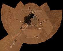
Sacagawea Panorama by Opportunity (Marathon Valley)
In 2016, the United States' space mission MER, operating the MER-B Opportunity rover took a special panoramic image called the Sacagawea Panorama in honor of the Lemhi Shoshone woman that helped the Lois and Clark expedition on their journey of exploration across America in 1804 to 1806.[37] The image was taken of Marathon Valley at Endeavour Crater on the planet Mars.[37]

Comparison
Enedeavour is about the same size as Valles Caldera in the U.S. State of New Mexico;a volcanic Caldera of the Valles Caldera National Preserve.[22] Endeavour has been compared to the Mars craters' Santa Fe (crater), which is about 20.2 km in diameter, and also to Tooting (crater), which is 27.5 km in diameter.[14]
See also
- List of craters on Mars
- Geography of Mars
- Cape York (Mars) (Point on western ridge where Mars rover Opportunity arrived at in 2011)
- Solander Point (Point on western ridge ascended by a Mars rover Opportunity in 2013)
- Nearby Locations in Meridiani Planum:
References
- 1 2 3 4 "NASA'S Mars Rover to Head Toward Bigger Crater". NASA/JPL. 2008-09-22. Retrieved 2009-03-20.
- ↑ "Road Trip Gets Under Way". NASA/JPL. 2008-09-24. Retrieved 2009-04-27.
- 1 2 "Planetary Names: Crater, craters: Endeavour on Mars". Gazetteer of Planetary Nomenclature. Retrieved 2016-02-14.
- 1 2 http://www.planetary.org/explore/space-topics/space-missions/mer-updates/2008/09-30-mer-update.html
- ↑ Wray, J. J.; et al. (November 2009), "Phyllosilicates and sulfates at Endeavour Crater, Meridiani Planum, Mars", Geophysical Research Letters, 36 (21), Bibcode:2009GeoRL..3621201W, doi:10.1029/2009GL040734
- 1 2 Chojnacki, M.; Burr, D. M.; Moersch, J. (March 2010), "Recent Dune Changes at Endeavour Crater, Meridiani Planum, Mars, from Orbital Observations", 41st Lunar and Planetary Science Conference, held March 1–5, 2010, The Woodlands, Texas, p. 2326, Bibcode:2010LPI....41.2326C
- 1 2 Chojnacki, M.; Moersch, J.; Wray, J. J.; Burr, D. M. (March 2010), "The Stratigraphy, Composition and Thermophysical Properties of Endeavour Crater, Meridiani Planum, Mars, from Orbital Remote Sensing", 41st Lunar and Planetary Science Conference, held March 1–5, 2010, The Woodlands, Texas, p. 2175, Bibcode:2010LPI....41.2175C
- 1 2 3 4 "One Mars Rover Sees A Distant Goal; The Other Takes A New Route". NASA/JPL. 2009-03-18. Retrieved 2009-03-20.
- 1 2 "NASA Mars Rover Arrives at New Site on Martian Surface" (Press release). NASA/JPL. 2011-08-10. Retrieved 2016-02-14.
- ↑ http://www.nasa.gov/home/hqnews/2011/dec/HQ_11-403_Mars_Rover_Gypsum.html
- ↑ "Martian Crater Named Endeavour". USGS Astrogeology Science Center. 2008-10-20. Retrieved 2016-02-14.
- ↑
- ↑ NASA Mars Rover Seeing Destination in More Detail, NASA media release, 29 June 2010, accessed 25 July 2011
- 1 2 3 4 5 6
- 1 2
- 1 2 3
- ↑ "HRSC Press Release #471 - Orcus Patera (orbit 2216 & 2238)". 2010-08-27. Archived from the original on 2014-08-07.
- ↑
- 1 2
- 1 2
- 1 2 3 4
- 1 2
- ↑
- ↑ Rahl, A.J.S (2008-10-31). "Spirit "Bumps" a Move, Opportunity Puts the Pedal to the Metal". Planetary Society. Retrieved 2009-03-20.
- ↑ "NASA Rover Nears Martian Bowl Goal". NASA/JPL. 2006-09-06. Retrieved 2009-03-20.
- ↑ "Press Release Images: Opportunity". NASA/JPL. 2004-05-03. Retrieved 2009-03-20.
- ↑ "NASA Facts: Mars Exploration Rover" (PDF). NASA/JPL. 2004-10-24. Retrieved 2009-03-26.
- 1 2 "One Mars Rover Sees A Distant Goal; The Other Takes A New Route". NASA/JPL. 2009-03-18. Retrieved 2009-03-20.
- ↑ "Opportunity's Long and Winding Road to Endeavour Crater". Universe Today. 2010-05-05. Retrieved 2010-08-04.
- ↑ "Opportunity Rover Reaches Halfway Point of Long Trek". NASA/JPL. 2010-09-08. Retrieved 2010-09-11.
- ↑ "Opportunity Is Just Over a Mile From Crater Rim". NASA/JPL. 2011-07-08. Retrieved 2011-07-08.
- ↑ "Nearing First Landfall of Large Crater". NASA/JPL. 2011-08-04. Retrieved 2011-08-08.
- ↑ NASA - Sol 3351
- ↑
- ↑
- 1 2 Martian Reminder of a Pioneering Flight
- 1 2
External links
| Wikimedia Commons has media related to Endeavour crater. |
- Official Mars Rovers website
- Opportunity: Iazu Crater profiles (As seen from rim of Endeavour crater)
- Endeavour crater as seen during MER-B's approach to the crater with some locations noted around the crater
- HIRISE ANALYSIS OF THE WESTERN RIM OF ENDEAVOUR CRATER, MERIDIANI PLANUM, MARS: MORPHOLOGY, COMPOSITION AND TOPOGRAPHY. University of Tennessee
- HiRise - search for Endeavour crater related images
- HiRise - DTM - North-Central Endeavour Crater
- HiRise - DTM - Endeavour Crater Western Rim
- DLR - ExoMars Schiaparelli's landing site on Mars 11 August 2016
- HRSC Viewer
- HiRise image of the western rim
- Degradation of Endeavour Crater, Mars
Features on Mars visited by Opportunity rover | ||
|---|---|---|
| Craters | | |
| Endeavour | ||
| Rocks | ||
Mars Exploration Rover program | ||
|---|---|---|
| General |
|  |
| Spirit rover | ||
| Opportunity rover | ||
| Instruments |
| |
| Related |
| |
| Other | ||