Olympus Mons
 | |
| Coordinates | 18°39′N 226°12′E / 18.65°N 226.2°E[1]Coordinates: 18°39′N 226°12′E / 18.65°N 226.2°E[1] |
|---|---|
| Peak |
21,230 m (69,650 ft) above datum 22 km (72,000 ft) local relief 26 km (85,000 ft) above plains[2] |
| Discoverer | Mariner 9 |
| Eponym | Latin – Mount Olympus |
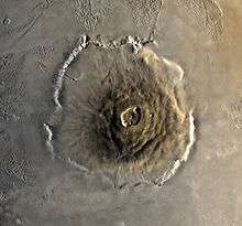
Olympus Mons (pronunciation: /əˌlɪmpəs ˈmɒnz, oʊ-, -ˈmɒns/;[3][4] Latin for Mount Olympus) is a very large shield volcano on the planet Mars. By one measure, it has a height of nearly 22 km (13.6 mi).[5] Olympus Mons stands about two and a half times as tall as Mount Everest's height above sea level. It is the youngest of the large volcanoes on Mars, having formed during Mars's Hesperian Period. It is currently the largest volcano discovered in the Solar System and had been known to astronomers since the late 19th century as the albedo feature Nix Olympica (Latin for "Olympic Snow"). Its mountainous nature was suspected well before space probes confirmed its identity as a mountain.[6]
The volcano is located in Mars's western hemisphere at approximately 18°39′N 226°12′E / 18.65°N 226.2°E,[1] just off the northwestern edge of the Tharsis bulge. The western portion of the volcano lies in the Amazonis quadrangle (MC-8) and the central and eastern portions in the adjoining Tharsis quadrangle (MC-9).
Two impact craters on Olympus Mons have been assigned provisional names by the International Astronomical Union. They are the 15.6 km (9.7 mi)-diameter Karzok crater (18°25′N 131°55′W / 18.417°N 131.917°W) and the 10.4 km (6.5 mi)-diameter Pangboche crater (17°10′N 133°35′W / 17.167°N 133.583°W).[7] The craters are notable for being two of several suspected source areas for shergottites, the most abundant class of Martian meteorites.[8]
Description

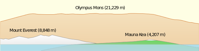
As a shield volcano, Olympus Mons resembles the shape of the large volcanoes making up the Hawaiian Islands. The edifice is about 600 km (370 mi) wide.[9] Because the mountain is so large, with complex structure at its edges, allocating a height to the structure is difficult. It stands 21 km (13 mi) above the Mars global datum, and its local relief, from the foot of the cliffs which form its margin to the northwest to its peak, is nearly 22 km (14 mi)[5] (a little over twice the height of Mauna Kea as measured from its base on the ocean floor). The total elevation change from the plains of Amazonis Planitia, over 1,000 km (620 mi) to the northwest, to the summit approaches 26 km (16 mi).[2] The summit of the mountain has six nested calderas (collapse craters) forming an irregular depression 60 km (37 mi) × 80 km (50 mi) across[10] and up to 3.2 km (2.0 mi) deep.[11] The volcano's outer edge consists of an escarpment, or cliff, up to 8 km (5.0 mi) tall (although obscured by lava flows in places), a feature unique among the shield volcanoes of Mars.[12] Olympus Mons covers an area approximately the size of Italy, or about 300,000 km2 (120,000 sq mi).[13]
Being a shield volcano, Olympus Mons has a very gentle profile. The average slope on the volcano's flanks is only 5°.[11] Slopes are highest near the middle part of the flanks and grow shallower toward the base, giving the flanks a concave upward profile. The shape of Olympus Mons is distinctly asymmetrical. Its flanks are shallower and extend out further from the summit in the northwestern direction than they do to the southeast. The volcano's shape and profile have been likened to a "circus tent" held up by a single pole that is shifted off center.[14]
Because of the size of Olympus Mons and its shallow slopes, an observer standing on the Martian surface would be unable to view the entire profile of the volcano, even from a great distance. The curvature of the planet and the volcano itself would obscure such a synoptic view.[15] Similarly, an observer near the summit would be unaware of standing on a very high mountain, as the slope of the volcano would extend far beyond the horizon, a mere 3 kilometers away.[16]
The typical atmospheric pressure at the top of Olympus Mons is 72 pascals, about 12% of the average Martian surface pressure of 600 pascals.[17][18] Both are exceedingly low by terrestrial standards. By comparison, the atmospheric pressure at the summit of Mount Everest is 32,000 pascals, or about 32% of Earth's sea level pressure.[19] Olympus Mons shows that there is a composition of 44% silicates, 17.5% iron oxides, giving the planet its red coloration, 7% aluminum, 6% magnesium, 6% calcium, and particularly high proportions of sulfur oxide with 7%. These results point to the fact that the surface is largely composed of basalts and other mafic rocks, which would have erupted as low viscosity lava flows and hence lead to the low gradients on the surface of the planet. After plate tectonics ceased on Mars, hotspots, which cause volcanoes such as these, remained under the same areas for a very long time, and the volcanoes kept growing. Olympus Mons is supported by a 70 km (43 mi) thick lithosphere.
Even so, high-altitude orographic clouds frequently drift over the Olympus Mons summit, and airborne Martian dust is still present.[20] Although the average Martian surface atmospheric pressure is less than one percent of Earth's, the much lower gravity on Mars increases the atmosphere's scale height; in other words, Mars's atmosphere is expansive and does not drop off in density with height as sharply as Earth's.
Olympus Mons is an unlikely landing location for automated space probes in the near future. The high elevations preclude parachute-assisted landings because of insufficient atmospheric thickness to slow the spacecraft down. Moreover, Olympus Mons stands in one of the dustiest regions of Mars. A mantle of fine dust covers much of the terrain, obscuring the underlying bedrock and possibly making rock samples hard to come by. The dust layer would also likely cause severe maneuvering problems for rovers.
Geology
Olympus Mons is the result of many thousands of highly fluid, basaltic lava flows that poured from volcanic vents over a long period of time. (The Hawaiian Islands exemplify similar shield volcanoes on a smaller scale – see Mauna Kea.)
-
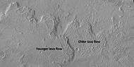
Lava flows on Olympus Mons with older and younger flows labeled, as seen by HiRISE under HiWish program
The extraordinary size of Olympus Mons is likely because Mars lacks mobile tectonic plates. Unlike on Earth, the crust of Mars remains fixed over a stationary hotspot, and a volcano can continue to discharge lava until it reaches an enormous height.[21] Like the basalt volcanoes on Earth, Martian basaltic volcanoes are capable of erupting enormous quantities of ash. The basalt found on Earth and Mars are very similar in composition. Due to the gravity on Mars, there are less buoyant forces on the magma rising out of the crust. Also, the magma chambers are thought to be much larger and deeper than the ones found on Earth.
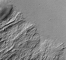
The flanks of Olympus Mons are made up of innumerable lava flows and lava channels. Many of the flows have levees along their margins (pictured). Levees are parallel ridges formed at the edges of lava flows. The cooler, outer margins of the flow solidify, leaving a central trough of molten, flowing lava. Partially collapsed lava tubes are visible as chains of pit craters, and broad lava fans formed by lava emerging from intact, subsurface tubes are also common.[22] In places along the volcano's base, lava flows can be seen spilling out into the surrounding plains, forming broad aprons, and burying the basal escarpment. (Note: Lava flows refer to both actively flowing lava and the solidified landforms they produce. The meaning here is the latter, since Mars has no active lava flows at the present time.) Crater counts from high-resolution images taken by the Mars Express orbiter in 2004 indicate that lava flows on the northwestern flank of Olympus Mons range in age from 115 million years old (Mya) to only 2 Mya.[23] These ages are very recent in geological terms, suggesting that the mountain may still be volcanically active, though in a very quiescent and episodic fashion.[24]

The caldera complex at the peak of the volcano is made of at least six overlapping calderas and caldera segments (pictured).[25] Calderas are formed by roof collapse following depletion and withdrawal of the subsurface magma chamber after an eruption. Each caldera thus represents a separate pulse of volcanic activity on the mountain.[26] The largest and oldest caldera segment appears to have formed as a single, large lava lake.[27] The size of a caldera is a reflection of the size of the underlying magma chamber. Using geometric relationships of caldera dimensions from laboratory models, scientists have estimated that the magma chamber associated with the largest caldera on Olympus Mons lies at a depth of about 32 km (105,000 ft) below the caldera floor.[28] Crater size-frequency distributions on the caldera floors indicate the calderas range in age from 350 Mya to about 150 Mya. All probably formed within 100 million years of each other.[29][30]
Olympus Mons is asymmetrical structurally as well as topographically. The longer, more shallow northwestern flank displays extensional features, such as large slumps and normal faults. In contrast, the volcano's steeper southeastern side has features indicating compression. They include step-like terraces in the volcano's mid-flank region (interpreted as thrust faults[31]) and a number of wrinkle ridges located at the basal escarpment. Why opposite sides of the mountain should show different styles of deformation is puzzling. The answer may lie in understanding how large shield volcanoes grow laterally and on how variations within the substrate of the volcano affect the final shape of the mountain.

Large shield volcanoes grow not only by adding material to their flanks as erupted lava, but also by spreading laterally at their bases. As a volcano grows in size, the stress field underneath the volcano changes from compressional to extensional. A subterranean rift may develop at the base of the volcano, causing the underlying crust to spread apart.[32] If the volcano rests on sediments containing mechanically weak layers (e.g., beds of water-saturated clay), detachment zones (decollements) may develop in the weak layers. The extensional stresses in the detachment zones can produce giant landslides and normal faults on the volcano's flanks, leading to the formation of a basal escarpment.[33] Further from the volcano, these detachment zones can express themselves as a succession of overlapping, gravity driven thrust faults. This mechanism has long been cited as an explanation of the Olympus Mons aureole deposits (discussed below).[34]

Olympus Mons lies at the edge of the Tharsis bulge, a vast volcanic plateau that is very ancient. The formation of Tharsis was likely complete by the end of the Noachian Period. At the time Olympus Mons began to form in Hesperian times, the volcano was located on a shallow slope that descended from the high in Tharsis into the northern lowland basins. Over time, these basins would have received large volumes of sediment eroded from Tharsis and the southern highlands. The sediments likely contained abundant Noachian-aged phyllosilicates (clays) formed during an early period on Mars when surface water was abundant.[35] The sediments would be thickest in the northwest where basin depth was greatest. As the volcano grew through lateral spreading, low-friction detachment zones preferentially developed in the thicker sediment layers to the northwest, creating the basal escarpment and widespread lobes of aureole material (Lycus Sulci). Spreading also occurred to the southeast; however, it was more constrained in that direction by the Tharsis rise, which presented a higher-friction zone at the volcano's base. Friction was higher in that direction because the sediments were thinner and probably consisted of coarser grained material resistant to sliding. The competent and rugged basement rocks of Tharsis acted as an additional source of friction. Thus, basal spreading of Olympus Mons was inhibited in the southeast direction, accounting for the structural and topographic asymmetry of the mountain. Numerical models of particle dynamics involving lateral differences in friction along the base of Olympus Mons have been shown to reproduce the volcano's present shape and asymmetry fairly well.[33]
The detachment along the weak layers was likely aided by the presence of high-pressure water in the sediment pore spaces. This possibility has interesting astrobiological implications. If water-saturated zones still exist in sediments under the volcano, they would likely have been kept warm by a high geothermal gradient and residual heat from the volcano's magma chamber. Potential springs or seeps around the volcano would offer exciting possibilities for detecting microbial life.[36]
Early observations and naming

Olympus Mons and a few other volcanoes in the Tharsis region stand high enough to reach above the frequent Martian dust-storms recorded by telescopic observers as early as the 19th century. The astronomer Patrick Moore pointed out that Schiaparelli (1835–1910) "had found that his Nodus Gordis and Olympic Snow [Nix Olympica] were almost the only features to be seen" during dust storms, and "guessed correctly that they must be high".[37]
The Mariner 9 spacecraft arrived in orbit around Mars in 1971 during a global dust-storm. The first objects to become visible as the dust began to settle, the tops of the Tharsis volcanoes, demonstrated that the altitude of these features greatly exceeded that of any mountain found on Earth, as astronomers expected. Observations of the planet from Mariner 9 confirmed that Nix Olympica was not just a mountain, but a volcano. Ultimately, astronomers adopted the name Olympus Mons for the albedo feature known as Nix Olympica.
Regional setting and surrounding features

Olympus Mons is located between the northwestern edge of the Tharsis region and the eastern edge of Amazonis Planitia. It stands about 1,200 km (750 mi) from the other three large Martian shield volcanoes, collectively called the Tharsis Montes (Arsia Mons, Pavonis Mons, and Ascraeus Mons). The Tharsis Montes are slightly smaller than Olympus Mons.
A wide, annular depression or moat about 2 km (1.2 mi) deep surrounds the base of Olympus Mons and is thought to be due to the volcano's immense weight pressing down on the Martian crust. The depth of this depression is greater on the northwest side of the mountain than on the southeast side.
Olympus Mons is partially surrounded by a region of distinctive grooved or corrugated terrain known as the Olympus Mons aureole. The aureole consists of several large lobes. Northwest of the volcano, the aureole extends a distance of up to 750 km (470 mi) and is known as Lycus Sulci (24°36′N 219°00′E / 24.6°N 219°E). East of Olympus Mons, the aureole is partially covered by lava flows, but where it is exposed it goes by different names (Gigas Sulci, for example). The origin of the aureole remains debated, but it was likely formed by huge landslides [12] or gravity-driven thrust sheets that sloughed off the edges of the Olympus Mons shield.[38]
Impact origin hypothesis
Although Olympus Mons has been almost universally viewed as an internally-generated volcano, a recently-proposed alternative explanation holds that it was created by impact melting by a large bolide.[39] Evidence for this interpretation includes Olympus’ circularity, concentric symmetry, gravitational properties, and the character of its surrounding deposits.
Olympus Mons is contained within a circular rim, inferred to be the outer margin of the impact basin within which a huge volume of melt was suddenly generated. The rim is preserved around much of the northwest and southeast quadrants of the mountain base, but has slumped out into debris flows around much of the rest of the perimeter. The mountain’s concentric ridges and broad summit plateau suggest formation from a single huge mass of spreading viscous lava. Debris flows and fans carry material outward as far as 200 km from the broken-rim sectors. Beyond that, the much wider aureole was formed by fluidized debris that began as impact ejecta, on several trajectories. There is no concentric topographic moat close around the mountain[40] to indicate isostatic depression by the mountain’s mass. This suggests the mass to be a surface load supported by a mantle that was effectively rigid, hence cold, at the time it formed and ever since.[41]
Olympus takes on a volcanic appearance in images with tenfold vertical exaggeration, but in true perspective does not resemble earthly volcanoes. For example, there is no evidence of the incremental growth along radial rift zones that typifies large intraplate volcanoes on Earth. The island of Hawaii, to which Olympus Mons has often been compared, is a much smaller, steeper, and irregularly-shaped composite of at least five volcanoes, unlike the circular and concentric structure of Olympus Mons.
Interactive Mars map
See also
References
- 1 2 3 "Olympus Mons". Gazetteer of Planetary Nomenclature. USGS Astrogeology Research Program.
- 1 2 Neil F. Comins – Discovering the Essential Universe (2012) – Page 148
- ↑ "Olympus". Merriam-Webster Dictionary., "Mons". Merriam-Webster Dictionary..
- ↑ "Olympus". Dictionary.com Unabridged. Random House. "Mons". Dictionary.com Unabridged. Random House.
- 1 2 Plescia, J. B. (2004). "Morphometric Properties of Martian Volcanoes". J. Geophys. Res. 109: E03003. Bibcode:2004JGRE..109.3003P. doi:10.1029/2002JE002031.
- ↑ Patrick Moore 1977, Guide to Mars, London (UK), Cutterworth Press, p.96
- ↑ "New names on Olympus Mons". USGS. Retrieved 2006-07-11.
- ↑ Frankel, C.S. (2005). Worlds on Fire: Volcanoes on the Earth, the Moon, Mars, Venus and Io; Cambridge University Press: Cambridge, UK, p. 160. ISBN 978-0-521-80393-9.
- ↑ "Olympus Mons", NASA, retrieved 30 August 2010.
- ↑ Mouginis-Mark, P.J.; Harris, A.J.L.; Rowland, S.K. (2007). Terrestrial Analogs to the Calderas of the Tharsis Volcanoes on Mars in The Geology of Mars: Evidence from Earth-Based Analogs, M. Chapman, Ed.; Cambridge University Press: Cambridge, UK, p. 84
- 1 2 Carr, Michael H. (11 January 2007). The Surface of Mars. Cambridge University Press. p. 51. ISBN 978-1-139-46124-5.
- 1 2 Lopes, R.; Guest, J. E.; Hiller, K.; Neukum, G. (January 1982). "Further evidence for a mass movement origin of the Olympus Mons aureole". Journal of Geophysical Research. 87 (B12): 9917–9928. doi:10.1029/JB087iB12p09917.
- ↑ Frankel, C.S. (2005). Worlds on Fire: Volcanoes on the Earth, the Moon, Mars, Venus and Io; Cambridge University Press: Cambridge, UK, p. 132. ISBN 978-0-521-80393-9.
- ↑ ScienceDaily (2009). Volcanic Spreading And Lateral Variations In Structure Of Olympus Mons, Mars, Feb. 15. http://www.sciencedaily.com/releases/2009/02/090203175343.htm.
- ↑ Hanlon, M. (2004). The Real Mars; Constable & Robinson: London, p. 22. ISBN 1-84119-637-1.
- ↑ Martian Volcanoes on HST Images How Far Could I See Standing on Olympus Mons, "2.37 miles", Jeff Beish, Former A.L.P.O. Mars Recorder Archived August 27, 2009, at the Wayback Machine.
- ↑ Public Access to Standard Temperature-Pressure Profiles Standard Pressure Profiles measured by MGS Radio Science team at 27 km (17 mi) range from approximately 30 to 50 Pa.
- ↑ Late Martian Weather! stanford.edu temperature/pressure profiles 1998 to 2005
- ↑ Kenneth Baillie & Alistair Simpson. "High altitude barometric pressure". Apex (Altitude Physiology Expeditions).
- ↑ Hartmann, W.K. A Traveler’s Guide to Mars: The Mysterious Landscapes of the Red Planet. Workman: New York, 2003, pp. 300.
- ↑ Layers in Olympus Mons Basal Scarp (PSP_001432_2015), High resolution imaging Science Experiment.
- ↑ Richardson, J.W. et al. (2009). The Relationship between Lava Fans and Tubes on Olympus Mons in the Tharsis Region, Mars. 40th Lunar and Planetary Science Conference, Abstract #1527. http://www.lpi.usra.edu/meetings/lpsc2009/pdf/1527.pdf.
- ↑ Martel, Linda M. V. (2005-01-31). "Recent Activity on Mars: Fire and Ice". Planetary Science Research Discoveries. Retrieved 2006-07-11.
- ↑ Soderblom, L.A.; Bell, J.F. (2008). Exploration of the Martian Surface: 1992–2007 in The Martian Surface: Composition, Mineralogy, and Physical Properties, J. Bell, Ed.; Cambridge University Press: Cambridge, UK, p. 15.
- ↑ Mouginis-Mark, P.J. (1981). Late-stage Summit Activity of Martian Shield Volcanoes. Proc. 12th Lunar and Planetary Science Conference; Houston: LPI, 12B, pp. 1431–1447.
- ↑ "Olympus Mons – the caldera in close-up". ESA. 2004-02-11. Retrieved 2006-07-11.
- ↑ Mouginis-Mark, P.J.; Harris, A.J.L.; Rowland, S.K. (2007). Terrestrial Analogs to the Calderas of the Tharsis Volcanoes on Mars in The Geology of Mars: Evidence from Earth-Based Analogs, M. Chapman, Ed.; Cambridge University Press: Cambridge, UK, p. 86
- ↑ Beddingfield, C.B.; Burr, D.M. (2011). Formation and Evolution of Surface and Subsurface Structures within the Large Caldera of Olympus Mons, Mars. 42nd Lunar and Planetary Science Conference. LPI: Houston, TX, Abstract #2386. http://www.lpi.usra.edu/meetings/lpsc2011/pdf/2386.pdf
- ↑ Neukum, G.; et al. (2004). "Recent and Episodic Volcanic and Glacial Activity on Mars Revealed by the High Resolution Stereo Camera". Nature. 432: 971–979. doi:10.1038/nature03231. PMID 15616551.
- ↑ Robbins, S.J. et al. (2010). Dating The Most Recent Episodes of Volcanic Activity From Mars's Main Volcanic Calderae (sic). 41st Lunar and Planetary Science Conference, Abstract 2252. http://www.lpi.usra.edu/meetings/lpsc2010/pdf/2252.pdf.
- ↑ Byrne, P.K. et al. (2009). An Overview of Volcano Flank Terraces on Mars. 40th Lunar and Planetary Science Conference. LPI: Houston, abstract #2192. http://www.lpi.usra.edu/meetings/lpsc2009/pdf/2192.pdf.
- ↑ Borgia, A (1994). "Dynamic Basis of Volcanic Spreading". J. Geophys. Res. 99 (B4): 17791–17804. Bibcode:1994JGR....9917791B. doi:10.1029/94jb00578.
- 1 2 McGovern, P.J.; Morgan, J.K. (2009). "Volcanic Spreading and Lateral Variations in the Structure of Olympus Mons, Mars". Geology. 37 (2): 139–142. doi:10.1130/g25180a.1.
- ↑ Francis, P.W.; Wadge, G. (1983). "The Olympus Mons Aureole: Formation by Gravitational Spreading". J. Geophys. Res. 88 (B10): 8333–8344. Bibcode:1983JGR....88.8333F. doi:10.1029/jb088ib10p08333.
- ↑ Bibring, Jean-Pierre; et al. (2006). "Global Mineralogical and Aqueous Mars History Derived from OMEGA/Mars Express Data". Science. 312 (5772): 400–404. doi:10.1126/science.1122659. PMID 16627738.
- ↑ McGovern, P.J. (2010). Olympus Mons: A Primary Target for Martian Biology. Astrobiology Science Conference, LPI, Abstract #5633. http://www.lpi.usra.edu/meetings/abscicon2010/pdf/5633.pdf.
- ↑ Moore 1977, Guide to Mars, p.120
- ↑ Cattermole P. Mars: the Mystery Unfolds; Oxford University Press: New York, 2001.
- ↑ Hamilton, W.B., 2015, Terrestrial planets fractionated synchronously with accretion, but Earth progressed through subsequent internally dynamic stages whereas Venus and Mars have been inert for more than 4 billion years. Pp. 123–156 in Foulger, G.R., Lustrino, M., and King, S.D., eds., The Interdisciplinary Earth: A Volume in Honor of Don L. Anderson. Geological Society of America Special Paper 514 and American Geophysical Union Special Publication 71. doi:10.1130/2015.2514(09). http://www.mantleplumes.org/DLABook/Hamilton2015.pdf
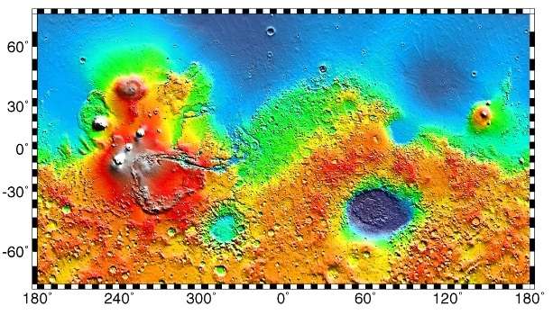
- ↑ U.S. Geological Survey, 2002, Color-coded contour map of Mars [from MOLA topography]: Open-File Report 02-283.
- ↑ Lowry, A.R., and Zhong, S., 2003, Surface versus internal loading of the Tharsis rise, Mars: Journal of Geophysical Research, v. 108, no. 39, paper 3.
External links
| Wikimedia Commons has media related to Olympus Mons. |
- Astronomy Picture of the Day 26 May 2004
- Western Flank of Olympus Mons and Aureole
- Volcanism on Mars
- Olympus Mons from Google Mars