East Derry, New Hampshire
| East Derry, New Hampshire | |
|---|---|
| Unincorporated community | |
|
First Parish Congregational Church | |
 East Derry  East Derry | |
| Coordinates: 42°53′40″N 71°17′28″W / 42.89444°N 71.29111°WCoordinates: 42°53′40″N 71°17′28″W / 42.89444°N 71.29111°W | |
| Country | United States |
| State | New Hampshire |
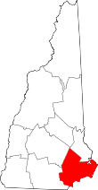
| County | Rockingham |
| Town | Derry |
| Elevation | 430 ft (130 m) |
| Time zone | Eastern (EST) (UTC-5) |
| • Summer (DST) | EDT (UTC-4) |
| ZIP code | 03041 |
| Area code(s) | 603 |
| GNIS feature ID | 866704[1] |

East Derry is an unincorporated community in the town of Derry in Rockingham County, New Hampshire. The village center constitutes the East Derry Historic District, listed on the National Register of Historic Places.
It is located on a hill close to the geographic center of the town of Derry along East Derry Road, approximately 2 miles (3 km) east of the built-up town center of Derry.
East Derry has a separate ZIP code (03041) from the rest of the town of Derry. Alan Shepard lived in the village as a boy.
Station #4 of the Derry Fire Department is located in the village.[2]
See also
References
- ↑ "East Derry". Geographic Names Information System. United States Geological Survey.
- ↑ "Derry Fire Department Station Locations". Derry Fire Department. Retrieved December 15, 2014.
| Topics | 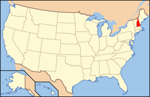 | |
|---|---|---|
| Lists by county | ||
| Other lists | ||
| ||
This article is issued from Wikipedia - version of the 6/22/2016. The text is available under the Creative Commons Attribution/Share Alike but additional terms may apply for the media files.