Auburn, New Hampshire
| Auburn, New Hampshire | ||
|---|---|---|
|
Massabesic Lake and the east shore in 1920 | ||
| ||
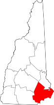
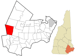 Location in Rockingham County and the state of New Hampshire. | ||
| Coordinates: 43°00′16″N 71°20′54″W / 43.00444°N 71.34833°WCoordinates: 43°00′16″N 71°20′54″W / 43.00444°N 71.34833°W | ||
| Country | United States | |
| State | New Hampshire | |
| County | Rockingham | |
| Incorporated | 1845 | |
| Government | ||
| • Board of Selectmen |
James F. Headd, Chair Richard W. Eaton Dale W. Phillips | |
| • Town Administrator | William G. Herman | |
| Area | ||
| • Total | 28.7 sq mi (74.3 km2) | |
| • Land | 25.2 sq mi (65.3 km2) | |
| • Water | 3.5 sq mi (9.1 km2) 12.20% | |
| Elevation | 253 ft (77 m) | |
| Population (2010) | ||
| • Total | 4,953 | |
| • Density | 75.9/sq mi (29.3/km2) | |
| Time zone | Eastern (UTC-5) | |
| • Summer (DST) | Eastern (UTC-4) | |
| ZIP code | 03032 | |
| Area code(s) | 603 | |
| FIPS code | 33-02820 | |
| GNIS feature ID | 0873536 | |
| Website |
www | |


Auburn is a town in Rockingham County, New Hampshire, United States. The population was 4,953 at the 2010 census,[1] with an estimated population of 5,158 in 2013.[2] The town was ranked number one of "New Hampshire's Most Beautiful Towns" in July 2010 by WMUR News 9.
History
Auburn was originally settled by Native Americans in 1624. It was a fishing settlement called by Native Americans "Massabesic" (the current name of the town's largest lake). British settlers arrived in the area in 1720 and made peace with the Native Americans until the French and Indian War. The Massabesic settlement was destroyed, and the nearby town of Chester claimed the land. It was known as Chester Woods, Chester West Parish, Long Meadow,[3] and then Auburn. Auburn became an independent town on June 25, 1845,[3] with a population of 1,200 people. As with Auburn, Maine, Auburn, Massachusetts and Auburn, New York, the name is from Oliver Goldsmith's popular 18th-century poem, "The Deserted Village", which begins:
- Sweet Auburn! loveliest village of the plain,
- Where health and plenty cheered the labouring swain
- Where smiling spring its earliest visit paid,
- And parting summer's lingering blooms delayed
Auburn was served by the Concord and Portsmouth Railroad, which later became the Portsmouth Branch of the Boston & Maine Railroad.[3] Auburn was home to a small passenger depot at one time, but by the mid 1900s most rail activity was through traffic as Auburn had few on-line industries. The last freight trains passed through in the early 1980s. The track was abandoned in 1982 and subsequently torn up between 1983 and 1985.
Geography
According to the United States Census Bureau, the town has a total area of 28.7 square miles (74.3 km2), of which 25.2 sq mi (65.3 km2) is land and 3.5 sq mi (9.1 km2), or 12.20%, is water.[1] Massabesic Lake, located in the western part of Auburn and the eastern part of Manchester, is the largest body of water in Auburn and serves as the city water supply for Manchester. The lake is fed by numerous tributaries, most notable being Sucker Brook, which enters the northeast end of the lake near the Auburn town center and itself drains several lakes, including Tower Hill Pond, Clark Pond, and Little Massabesic Lake. Cohas Brook flows through the eastern portion of Auburn and eventually (in Manchester) receives the outflow of Massabesic Lake before flowing west to the Merrimack River. Auburn lies fully within the Merrimack River watershed.[4] Three hills, all overlooking Massabesic Lake, can lay potential claim to being Auburn's highest point: Mount Miner, at 582 feet (177 m) above sea level, located north of the lake; Mine Hill, greater than 580 ft (180 m), above the east shore; and Mount Misery, greater than 580 feet, to the southeast.
Demographics
| Historical population | |||
|---|---|---|---|
| Census | Pop. | %± | |
| 1840 | 869 | — | |
| 1850 | 810 | −6.8% | |
| 1860 | 886 | 9.4% | |
| 1870 | 815 | −8.0% | |
| 1880 | 719 | −11.8% | |
| 1890 | 631 | −12.2% | |
| 1900 | 682 | 8.1% | |
| 1910 | 637 | −6.6% | |
| 1920 | 652 | 2.4% | |
| 1930 | 735 | 12.7% | |
| 1940 | 807 | 9.8% | |
| 1950 | 1,158 | 43.5% | |
| 1960 | 1,292 | 11.6% | |
| 1970 | 2,035 | 57.5% | |
| 1980 | 2,883 | 41.7% | |
| 1990 | 4,085 | 41.7% | |
| 2000 | 4,682 | 14.6% | |
| 2010 | 4,953 | 5.8% | |
| Est. 2015 | 5,292 | [5] | 6.8% |
As of the census[7] of 2000, there were 4,682 people, 1,580 households, and 1,322 families residing in the town. The population density was 185.7 people per square mile (71.7/km²). There were 1,622 housing units at an average density of 64.3 per square mile (24.8/km²). The racial makeup of the town was 98.29% White, 0.21% African American, 0.23% Native American, 0.41% Asian, 0.23% from other races, and 0.62% from two or more races. Hispanic or Latino of any race were 0.94% of the population.
There were 2,349 households out of which 44.4% had children under the age of 18 living with them, 75.1% were married couples living together, 5.2% had a female householder with no husband present, and 16.3% were non-families. 11.8% of all households were made up of individuals and 3.3% had someone living alone who was 65 years of age or older. The average household size was 2.96 and the average family size was 3.22.
In the town the population was spread out with 28.9% under the age of 18, 6.2% from 18 to 24, 33.0% from 25 to 44, 25.8% from 45 to 64, and 6.1% who were 65 years of age or older. The median age was 37 years. For every 100 females there were 103.6 males. For every 100 females age 18 and over, there were 103.2 males.
The median income for a household in the town was $70,774, and the median income for a family was $72,578. Males had a median income of $45,000 versus $33,365 for females. The per capita income for the town was $28,405. About 1.6% of families and 1.8% of the population were below the poverty line, including 0.7% of those under age 18 and 11.2% of those age 65 or over.
Since Auburn has an agreement with the city of Manchester that the city and the surrounding towns can use Massabesic Lake as a water source, Manchester, Chester, Candia, Hooksett and Derry pay Auburn an estimated $3 million for Lake Massabesic.
Attractions
Massabesic Lake covers over 2,500 acres (1,000 ha) in Auburn and Manchester and serves as the public water supply for the city of Manchester. Half of the lake (the half farthest from the public water intake) is used for less-intrusive types of boating. No swimming or other contact between users and water is allowed.[8] Devil's Den is a small cave east of Massabesic Lake. The Massabesic Audubon Center is in central Auburn, occupying Battery Point on the lake.[9] The Griffin Mill Dam along Little Massabesic Brook-Sucker Brook is in the northeastern part of the town.
Events and festivals
Lake Massabesic Duck Race
Every year, the Auburn Historical Association hosts an annual Duck Race near Massabesic Lake. It starts at the Griffin Mill Bridge over the Little Massabesic Brook-Sucker Brook where a truck dumps thousands of rubber ducks into the brook, and the race ends at a finish line on the other side of the waterfall. People buy individual ducks, with prizes going to the owners of the winning ducks. The event attracts thousands of onlookers each year. There are also games for younger kids, and visitors are able to access the Griffin Free Public Library.
Yacht Sail Boating Club race
Every Sunday, sometimes also during the week, the Yacht Sail Boating Club hosts a sailboat race. Members of the club start on the northern shore of Massabesic Lake, and it ends after going 3 laps around the lake. Many visitors enjoy watching the races from their kayaks, sailboats, and canoes, or at Battery Point, the northernmost point on the Massabesic Peninsula.
Book sale
The last weekend in July, the Griffin Free Public Library holds a huge book sale at the Auburn Village School. Approximately 10,000 books and games are sold, with all proceeds benefiting the library's programs.
Education
Auburn is part of School Administrative Unit 15, along with the neighboring towns of Hooksett and Candia. SAU-15 administers five schools with Auburn Village School, serving all elementary school and middle school students (grades K-8) in the town.[10]
SAU-15 has no high school; students from Auburn attend high school in neighboring school districts, either Manchester Memorial High School or Pinkerton Academy (in Derry).
Notable people
- Joe Dudek, member of the College Football Hall of Fame.[11]
- Carl Forsaith, author of Auburn, New Hampshire, the town's official history book
- Albert Plummer, physician and legislator
- Stella Tremblay, former state representative for Rockingham County District 4, Boston Marathon bombings conspiracy theorist
See also
References
- 1 2 "Geographic Identifiers: 2010 Demographic Profile Data (G001): Auburn town, Rockingham County, New Hampshire". U.S. Census Bureau, American Factfinder. Retrieved December 13, 2013.
- ↑ "Annual Estimates of the Resident Population: April 1, 2010 to July 1, 2013 (PEPANNRES): Minor Civil Divisions, New Hampshire". U.S. Census Bureau, American Factfinder. Retrieved March 23, 2015.
- 1 2 3 Article in Statistics and Gazetteer of New-Hampshire (1875)
- ↑ Foster, Debra H.; Batorfalvy, Tatianna N.; Medalie, Laura (1995). Water Use in New Hampshire: An Activities Guide for Teachers. U.S. Department of the Interior and U.S. Geological Survey.
- ↑ "Annual Estimates of the Resident Population for Incorporated Places: April 1, 2010 to July 1, 2015". Retrieved July 2, 2016.
- ↑ "Census of Population and Housing". Census.gov. Archived from the original on May 11, 2015. Retrieved June 4, 2016.
- ↑ "American FactFinder". United States Census Bureau. Archived from the original on September 11, 2013. Retrieved 2008-01-31.
- ↑ "Boating on Lake Massabesic". City of Manchester. Retrieved March 21, 2011.
- ↑ "Massabesic Audubon Center, Auburn". New Hampshire Audubon. Archived from the original on March 12, 2011. Retrieved March 21, 2011.
- ↑ "SAU 15 official website". Retrieved 10 November 2015.
- ↑ "Where are they now? Plymouth State Football Legend Joe Dudek
External links
- Town of Auburn official website
- New Hampshire Economic and Labor Market Information Bureau Profile
- Auburn Police Department
- Auburn Fire Department