Early March 2015 United States winter storm
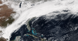 The elongated winter storm moving over the East Coast early on March 5. | |
| Type |
Extratropical cyclone Winter storm Ice storm Blizzard |
|---|---|
| Formed | March 1, 2015 |
| Dissipated | March 7, 2015 |
| Lowest pressure | 993 mb (29.32 inHg)[1] |
| Maximum snowfall or ice accretion |
Snowfall – 54.6 in (139 cm) in Schofield Pass, Colorado Ice – 0.25 in (6.4 mm) near Jackson, Mississippi |
| Areas affected | Southwestern United States, High Plains, Upper Midwest, Southeastern United States, Northern Mexico, Northeastern United States |
| Part of the 2014–15 North American winter | |
In the beginning of March 2015, a significant winter storm plowed through much of the United States, bringing 1–2 feet (12–24 in) of snow and record cold temperatures behind it.[2][3] The storm actually occurred in two phases, with the latter bringing the cold temperatures behind it in its wake. Record cold temperatures even spread down to as far as northern Florida.
Meteorological history
The first phase of the storm came on March 2, as a vigorous area of low pressure formed along an arctic cold front. Drawing some moisture from the so-called "Pineapple Express" from the Pacific, snowfall began to develop in the Upper Midwest, spreading a swath of accumulating snow ranging from 3–6 inches (7.6–15.2 cm) into March 3.[4] Snow began to push into the Northeast by the evening, with generally light accumulations, before tapering off and changing to rain showers later that night. As the initial area of low pressure moved into the northeastern parts of Canada, its cold front lingered, stretching from Maine to western Texas. Because of the "Pineapple Express" pumping moisture into just about the same area where this arctic front was set up, snow began to break out as a plume of precipitation began to take shape by mid-day on March 4. This was the start of the final phase of the winter storm.[5] An icing threat also loomed ahead as well, stretching into the southwestern part of the Mid-Atlantic. A new area of low pressure then formed near the Arkansas–Louisiana border and began to track eastward. Rain changed to moderate snowfall by 1 a.m EDT March 5, as cold air began to sank in. A long swath of snow then began to stretch from the southeastern tip of Massachusetts, into New York City, all the way down to the northern parts of Mississippi.[6] Snow from this system was that of the dry, fluffy kind, which was one reason power outages weren't so severe in the Northeast, however there was more in the ice portion of the storm. The storm continued to dump snow, ice and sleet across the eastern half of the United States, before moving off the coast late on March 5, leaving snow accumulations of 6–12 inches (15–30 cm) into the Northeast,[4] and record cold in its wake, with some areas experience a near 50 °F (10 °C) drop in 24 hours as the arctic front moved through.[2]
Impact
Snowfall totals
This is a list of the largest snowfall reports by state impacted by the storm. Source:[3]
- 11 inches (28 cm) in Brookport and Mound City
- 11 inches (28 cm) in Charlestown
- 1.1 inches (2.8 cm) in Olin
- 3.5 inches (8.9 cm) in Liberal
- 5.3 inches (13 cm) in Newberry
- 6.5 inches (17 cm) in Wrenshall
- 15.5 inches (39 cm) in Kennett
- 6 inches (15 cm) near Harrison
- 17 inches (43 cm) near Waterloo
- 5 inches (13 cm) near Porcupine
- 6 inches (15 cm) in Iron River
- 9 inches (23 cm) at Ledyard Center
- 7.5 inches (19 cm) near Fort Kent
- 15 inches (38 cm) at Highfield
- 12 inches (30 cm) at Dennisport
- 4 inches (10 cm) in Pittsburg
- 8.8 inches (22 cm) in Scotch Plains and Roselle Park
- 9.5 inches (24 cm) in Great Kills
- 11.3 inches (29 cm) in East Nantmeal
- 12 inches (30 cm) at Saunderstown and South Kingstown
- 3.5 inches (8.9 cm) near Cabot
- 9.4 inches (24 cm) at Washington Dulles International Airport,
- 14 inches (36 cm) in Buckeye and Davis
- 11 inches (28 cm) near Bono
- 25 inches (64 cm) near Radcliff
- 4.4 inches (11 cm) near Horn Lake
- 5 inches (13 cm) in Cordell
- 13.5 inches (34 cm) in Martin
- 7 inches (18 cm) in Grapevine
- 12 inches (30 cm) near Parks
- 32 inches (81 cm) at Squaw Valley
- 54.6 inches (139 cm) at Schofield Pass
- 24 inches (61 cm) at Diamond Peak Ski Resort
- 21 inches (53 cm) at Taos Ski Area
- 49 inches (120 cm) at Buckboard Flat
- 18 inches (46 cm) on Casper Mountain
Travel
The winter storm snarled travel across many areas in the United States, including a massive pileup on Interstate 65 in Kentucky, in which some people were stranded on the highway for hours.[7][8] Several other travel-related issues included a 14-car pileup on Interstate 459 in Alabama, a jackknifed semi and flipped snow plow in Washington D.C, a Delta plane traveling from Atlanta to New York City skidding off a snowy runway at LaGuardia Airport, and much more.[7]
Records
Multiple records were set during and after the storm, with primary more after the storm had past.
Below is a list of records set during the winter storm. Sources:[2][3]
- Heaviest two-day snowstorm in Lexington, Kentucky
- Multiple record lows for March 5–6 across the Lower 48.
References
- ↑ "WPC Surface Analysis Archive". Retrieved 10 April 2016.
- 1 2 3 "Record-Breaking Cold: All-Time March Record Lows Set". The Weather Channel. March 7, 2015. Retrieved April 3, 2016.
- 1 2 3 "Winter Storm Thor: Record Two-Day Snowstorm in Lexington, Kentucky; Snow, Ice, Flooding Reports". The Weather Channel. March 6, 2015. Retrieved April 10, 2016.
- 1 2 "Winter Storm Thor: Significant Snow, Sleet, Ice Maker in the South and East (RECAP)". The Weather Channel. March 6, 2015. Retrieved April 3, 2016.
- ↑ Jeff Halverson (6 March 2015). "'Polar' meets 'pineapple': The meteorology behind a unique winter storm". Washington Post. Retrieved 10 April 2016.
- ↑ "The Weather Channel on Twitter". Twitter.
- 1 2 "News". The Weather Channel. 3 March 2015. Retrieved 10 April 2016.
- ↑ Antoinette Konz (5 March 2015). "UPDATE: I-65 shut down near Elizabethtown, hundreds of motorists - WDRB 41 Louisville News". Retrieved 10 April 2016.