January 2014 United States blizzard
| Category 1 "Notable" (RSI: 1.30) | |
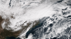 The winter storm developing off the Mid-Atlantic coast on January 21. | |
| Type |
Extratropical cyclone Winter storm Bomb cyclone Blizzard |
|---|---|
| Formed | January 19, 2014 |
| Dissipated | January 24, 2014 |
| Lowest pressure | 962 mb (28.41 inHg) |
| Maximum snowfall or ice accretion | 18.3 in (46 cm) in Norwell, Massachusetts |
| Areas affected | Eastern United States (especially the Mid-Atlantic states) |
| Part of the 2013–14 North American winter | |
In mid-to-late January 2014, a fast-moving but disruptive blizzard moved through the Northeast, mainly the Mid-Atlantic states, dumping up to 1 foot (12 in) in areas around the New York City area.[1] The storm also brought cold temperatures behind it afterwards, similar to how a previous snowstorm had done before.
Meteorological history
On January 19, a weak Alberta clipper exited out of Canada, and quickly moved through the Upper Midwest on January 20, dropping little to no accumulations of snowfall. As it moved eastward early on January 21, frontogenesis occurred, and precipitation expanded from Indiana to western Pennsylvania. At the same time though, an upper low was tracking through the area, and this was holding the clipper system along with it. Then, as it neared the coast, a new area of low pressure developed off the Outer Banks and began to move northwards, as snowfall expanded into parts of the Mid-Atlantic, reaching into areas like Connecticut. Most of the precipitation associated with this system was snowfall, due to an ongoing cold wave, which due to this made forecasting very easy. As the new low continued to move northwards, winds began to pick up along the coast, which at times led to blizzard conditions. The system also started to rapidly deepen as it started to pull away from the Northeast, dropping from 1,004 millibars (29.6 inHg) at 15:00 UTC January 21, to 979 millibars (28.9 inHg) at 15:00 UTC January 22, a drop of 25 millibars (0.74 inHg) in 24 hours.[2][3] Snow from the system continued to linger into January 22–23 even as it continued to pull away from the New England coast. The system continued to intensify up to its peak intensity of 962 millibars (28.4 inHg), after which it gradually started to weaken before dissipating on January 24.
Impact
Snowfall totals
Below are a list of snowfall totals above 12 inches. Snowfall totals from the lake-effect snow that followed is not included.
Source:[1]
| Amount | City/location | State |
|---|---|---|
| 18.3 inches (46 cm) | Norwell | MA |
| 18 inches (46 cm) | Hanover | MA |
| 16.8 inches (43 cm) | Sharon | MA |
| 15.8 inches (40 cm) | Manalapan | NJ |
| 15.1 inches (38 cm) | Englishtown | NJ |
| 14.8 inches (38 cm) | Brookhaven | PA |
| 14.5 inches (37 cm) | Selden | NY |
| 14.5 inches (37 cm) | North Babylon | NY |
| 13.5 inches (34 cm) | Philadelphia | PA |
| 13.3 inches (34 cm) | Lindenhurst | NY |
| 13 inches (33 cm) | East Rutherford | NJ |
| 12.2 inches (31 cm) | West Glocester | RI |
| 12.1 inches (31 cm) | Scarsdale | NY |
| 12 inches (30 cm) | Pike Creek | DE |
Naming phenomenon
The winter storm saw several mentions in social media, most of it due to graphical errors that occurred during The Weather Channel's coverage of the storm. The network had assigned the name Janus, named after the God of the same name, to the storm. However, because of a computer graphic error, the "J" in the storm's name was omitted and could barely be seen, making the wording look like it read Winter Storm Anus. This small glitch caused major buzz across the Internet, with some people even criticising The Weather Channel for this.
The glitch in the graphic was first posted on Reddit on January 22, and from there quickly spread across the Internet and news. Huffington Post described the humorous error as "a storm that would never want you to leave home",[4] while other news outlets described it as "a pain in the butt".[5]
See also
- Early January 2014 nor'easter – the previous winter storm that impacted similar areas.
- January 2015 North American blizzard – a stronger blizzard that impacted nearly the same areas with a very similar origin.
- January 2016 United States blizzard – crippling and historic blizzard that dropped up to 3 feet (36 in) in nearly the same exact areas.
References
- 1 2 "Winter Storm Janus Snow Totals: Mid-Atlantic and Northeast Get Hammered". The Weather Channel. 22 January 2014. Retrieved 29 March 2016.
- ↑ "WPC Surface Analysis Archive". Retrieved 29 March 2016.
- ↑ "WPC Surface Analysis Archive". Retrieved 29 March 2016.
- ↑ "Weather reporter warns country of 'Winter Storm Anus'". metro.us. 22 January 2014. Retrieved 29 March 2016.
- ↑ "Winter Storm Janus awkwardly loses a letter in on air graphic". newscaststudio.com. Retrieved 29 March 2016.