Doti
| Doti- डोटी/डोटीगढ़ (सुदुर पश्चिमाञ्चल - Sudura Paścimāñcala) | |
| Far-Western Development Region, (Manaskhand) | |
| Region | |
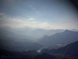 Seti River valley with Dipayal to the left | |
| Country | |
|---|---|
| Zones | Mahakali, Seti |
| Headquarters | Dipayal Silgadhi |
| Area | 19,539 km2 (7,544 sq mi) |
| Population | 2,552,517 (2011) [1] |
| Density | 131/km2 (339/sq mi) |
| Timezone | NPT (UTC+5:45) |
| ISO 3166-2 | NP-5 |
 Location of the Far-Western Region
| |
Doti (Devnagari; डोटी), also known as Doti region, Dotigarh (डोटीगढ़) as used in the Jagar (folk tales; जागर), and the Farwestern region of Nepal, is a region situated between River Kali boarding to the Uttarakhand in the west and Karnali river on the east.[2]
Districts
Doti division covers the nine districts of Seti and Mahakali Zone, four in Mahakali and five in Seti Zone respectively. They are:
- Darchula District
- Baitadi District
- Dadeldhura District
- Kanchanpur District
- Doti District
- Kailali District
- Bajhang District
- Bajura District
- Achham District
Kailali and Kanchanpur District are Terai districts.
Etymology
The name Doti is believed to have originated form the word Dovati, which means the land area between the confluence of two rivers.
Other view is that the original name of Doti was devatavi= dev+aatavi or aalaya (dev meaning Hindu God and aatavi meaning the place of re-creation or the place of attaining a meditation in Sanskrit).[3]
History
Doti was an ancient kingdom in far western region of Nepal which was formed after the disintegration of the Katyuri Kingdom of Kumaon around 13th century.[4]
Doti was one of eight different princely states Katiyuri Kingdom was divided into Eight for their eight Prince and became different independent Kingdom.
Later on, the whole land between Ramganga on the west (Uttarakhand) and the Karnali on the east (which divides the far western region from other parts Nepal), came under the Raikas after the origin of Raikas of Katyuris in Doti.[5]
"Brahma Dev Mandi" at Kanchanpur District of Mahakali Zone was established by Katyuri king Brahma Dev.[6]
Raikas of Doti
Niranjan Malla Dev was the founder of Doti Kingdom around 13th century after the fall of the Katyuri Kingdom. He was the son of Last Katyuris of united Katyuris kingdom.[7]
Kings of Doti were called Raikas (also Rainka Maharaj).[8] Later on Raikas, after defeating the Khas Malla of Karnali Zone, were able to establish a strong Raikas Kingdom in Far Western Region and Kumaun which was Doti. So far, the historical evidences[9] of following Raikas have been discovered:
- Niranjan Malla Dev (Founder of Doti Kingdom)
- Nagi Malla (1238)
- Ripu Malla (1279)
- Nirai Pal (1353): maybe of Askot [10] his historical evidence of 1354 A.D has been found in Almora too[11]
- Nag Malla (1384)
- Dhir Malla (1400)
- Ripu Malla (1410)
- Anand Malla (1430)
- Balinarayan Malla: not known
- Sansar Malla (1442)
- Kalyan Malla (1443)
- Suratan Malla (1478)
- Kriti Malla (1482)
- Prithivi Malla (1488)
- Medini Jay Malla (1512)
- Ashok Malla (1517)
- Raj Malla (1539)
- Arjun Malla/Shahi: not known but he was ruling Sira as Malla and Doti as Shahi[12]
- Bhupati Malla/Shahi (1558)
- Sagaram Shahi (1567)
- Hari Malla/Shahi (1581): last Raikas King of Sira and adjoining part of Nepal[12][13]
- Rudra Shahi (1630)
- Vikram Shahi (1642)
- Mandhata Shahi (1671)
- Raghunath Shahi (1690)
- Hari Shahi (1720)
- Hrishna Shahi (1760)
- Deep Shahi (1785),
- Prithivi pati Shahi (1790): he had fought against Nepali Ruler (Gorkhali Ruler) with British in 1814 A.D.[14]
Conflict With Gorkhalis
The historic place of war between the Doti Kingdom and Nepal (Gorkha Kingdom) during the period of Gorkha Expansion in 1790, according to the history of Nepal, is Nari-Dang which lies on the bank of the Seti River and Dumrakot was the base of the Doti Kingdom during the fighting against the Gorkhalis. In the war with the Gorkhalis,the Doti kingdom was defeated and Doteli King fled to Pilibhit.[15]
Mogul invasion on Far-Western Nepal
During the period of Akbar's rule in the 16th century, the Moguls had attacked the Raikas of Doti. They invaded Ajemeru, capital of the Raika Kingdom. Ajemeru is now in Dadeldhura District of far western region of Nepal. Hussain Khan, army chief of Akbar residing in Lucknow had led the attack. According to `Abd al-Qadir Bada'uni (c. 1540 - 1615), Indo-Persian historian during Mughal Empire, Mughal Army chief of Lukhnow, Hussian Khan, lured by the wealth and treasures of the kingdom of the Raikas, wanted to plunder the state, this being the motive behind the assault; but they did not succeed.
Khairgarh-Singhai State
Raja Deep Shahi was expelled from Nepal in 1790 A.D and on arriving to Terai of Oudh (now Lakhimpur Kheri District of Uttar Pradesh of India) he established Khairgarh-Singhai State in Khairigarh under British India.[16] Kanchanpur Praganna (now the District of Kaillali and Kanchanpur of Nepal) was also the parts of his State or Zamindari. He succeeded in defeating the Banjaras rural of Khairigarh and establishing himself not only in that Pargana but also in parts of Bhur. His state was merged with India In 1947 after Indian Independence. Raja Akshya Vikram Shah, 37, is the present ruler of Khairigarh.
Geography
The Far-Western Development Region has the Mid-Western Development Region to the east, Uttar Pradesh (India) to the south, Uttarakhand (India) to the west and the Tibet Autonomous Region (People's Republic of China) to the north.
The highest mountain in the region is the Api Peak, with 7,132 m (23,399 ft) high; it is in the Darchula district. Other high mountain is Saipal, 7,031 m (23,068 ft) high, in the Bajhang district.
The most important rivers in the Far-Western Development Region are the Seti and the Mahakali ( Kali orSharda in India) rivers; both rivers are tributaries of the Ghaghara or Karnali river.
Demographics
It is the smallest Development Region of Nepal with an area of 19,539 km2 (7,544 sq mi) and also with the lowest population with 2,552,517 people living there;[1] its population density is the second lowest of all the regions, with 130.6 persons/km2.
Language and culture
Dotiyali or Dotyali (Also Doteli) and Kumauni [17] is the local language spoken in Doti region or far western region of Nepal. Dotiyali which is similar to Kumauni language is one of language of Indo-European family. According to Rahul Sankrityayan, Dotiyali is the dialect of Kumauni language which was brought in Doti by section of Katyuri dynasty of kumaoun which had ruled over Doti till 1790. Therefore, It is mainly an offshoot of Katyuri language which is now in the form of mixture of several North Indian languages.Doti Kingdom was ruled by Katyuri Dynasty established after the destruction of previous Katyuri kingdom into eight different princely states.
According to the census (2011) total 7,87,827 of the population speaks Doteli and 2,72,524 of the population speaks Kumauni (Baitadeli) in Far western region of Nepal which is now recognized as a separate language of Nepal . Local intellectuals and people speaking Dotiyali language were increasingly demanding that their language be recognized as one of the other national languages of Nepal.
Inhabitants of two terai districts Kailali District and Kanchanpur District speak different languages. Rana-tharu and Dangaura-tharu speaks their own language. Language spoken by Rana-tharus is Hindi Dialect and Dangaura-tharu speaks Tharu Language.
Traditional dance and songs Chhaliya, Bhada, Jhora Chapeli, Rung Culture of Rung people (Sauka), Baira song, Deuda and Jagar are part of the culture. Jagara, tales of bravery is most important culture in Doti since Katyuri period. Jhusia Damai of Baskot of Baitadi District (stayed in Dharchula India) was famous Jagar singer.The major festivals of Doti are mainly Gora (Gamra), Kumauni holi, Bishpati, Harela, Raksha Bandhab (Rakhi) Dashin, Diwali, Makar Sankranti, and others.
See also
Further reading
- A New History of Uttarakhand Y. S. Kathoch
- Dotiyali language
- Dotyali Dictionary by R. Chattaut
- Stars of Seti by Punya Nepal
- History of Karnali Zone by R. Subedi
- Article
References
- 1 2 "National Population and Housing Census 2011" (pdf). Central Bureau of Statistics. Kathmandu, Nepal. November 2012. Retrieved 12 October 2013.
- ↑ Prof.Dr. Jay Raj pant wrote "Far-Western region of Nepal is called Doti Culturally " : In History of Doti Kingdom (2013)
- ↑ R.D Prabhas Chataut (2001) ; Dotyali Dictionary
- ↑ Dr.Y.S Kathoch, A New History of Uttarakhand; On Katiyuri Dynasty "Around,13th Century Katiyuri Dynasty established in Ranachulihat was broken into many sections" Doti was among them
- ↑ Advin T. Atkinson; Gazetteer Hindi Edition (2003); He wrote (Page 274) Whole territory to the east of Ram gang was belongs to Raikas during late 16th century..
- ↑ Dr. Madam Chandra Bhatt; A New History of Uttarakhand (2006): " Champawat ke Chand Raja.
- ↑ Dr. Y.S Kathoch; A New History of Uttarakhand(2006).Founder of Doti was Niranjan Mall Dev..
- ↑ Badri Datt Pandey ; History of Kumaun (1937)
- ↑ ..Sources of these historical evidence are taken from the books mentioned in the references.
- ↑ Prof. Maheshwor Prasad Joshi; "The Raikas of Kumaon and Western Nepal : The apigraphical survey" , JOURNAL OF INDOLOGICAL STUDY, Haryana Sahitya Academy (1998);.page 68..Nirai Pal of Askot had captured Sira because of political vacuum in Sira...
- ↑ Advin T. Atkinson ; Himalayan Gazetteer; ( Translated by Ramesh Thapaliyal ) Hindi Edition (2003) ISBN 8190100130;..Page 267..An old stone has found on the hills of Almora in which name Niraipal and 1348 written.
- 1 2 Dr. Ram Singh; A New History of Uttarakhand(2006).Mall Raikas of Sira..
- ↑ Advin T. Atkinson ; Himalayan Gazetteer; ( Translated by Ramesh Thapaliyal ) Hindi Edition (2003) ISBN 8190100130;..Page 285..Rudra Chand had captured whole territory east of kaliriver in 1581 along with Sira..
- ↑ Advin T Atkinson ; Himalayan Gazetteer Hindi Edition translated by Ramesh Thapaliyal (2003);ISBN 8190100130;..Ousted King of Doti Prithivipati Shah offered his help in war with Nepal which seemed very significant
- ↑ "History of Nepal". T.R.Vaidya Publications. Retrieved 2008-01-31.
- ↑ http://members.iinet.net.au/~royalty/ips/k/khairigarh.
- ↑ http://kcm.co.kr/bethany_eng/p_code1/1330.html