Bajura District
| Bajura बाजुरा | |
|---|---|
| District | |
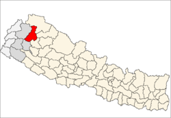 Location of Bajura | |
| Coordinates: 29°26′49″N 81°29′12″E / 29.44694°N 81.48667°ECoordinates: 29°26′49″N 81°29′12″E / 29.44694°N 81.48667°E | |
| Country | Nepal |
| Region | Far-Western (Sudur Pashchimanchal) |
| Zone | Seti |
| Headquarters | Martadi |
| Area | |
| • Total | 2,188 km2 (845 sq mi) |
| Elevation | 6,400 m (21,000 ft) |
| Population (2011) | |
| • Total | 134,912[1] |
| Time zone | NPT (UTC+5:45) |
| Main language(s) | Nepali |
| Website | http://www.badimalikamun.gov.np |
Bajura District (Nepali: बाजुरा जिल्ला![]() Listen ), a part of Province No. 7, is one of the seventy-five districts of Nepal. The district, with Martadi as its district headquarters, covers an area of 2,188 km² and had a population of 108,781 in 2001[2] and 134,912 in 2011.[1] The district has 1 Municipality, 24 VDCs, 9 Ilakas and 1 constituency areas. The district is situated in Longitude between 81° 10′ 20″ to 81° 48′ 27″ East and Latitude 29° 16′ 21″ to 29° 56′ 56″ North. Geographically the district is divided in three distinct regions from north to south viz. Higher Himalayan Region, Higher Mountain and mid – Mountains. The Higher Himalayan region comprises Saipal Himalayan range; High Mountain region comprises Doha Lekh and Ghori Lekh. Similarly, Mid-Mountain range comprises different ranges of mountains e.g. Badimalika Temple. The District has started from 300m to 6400m in height. The annual rainfall is about 13,433 mm and temperatures vary from 0 °C to 40 °C. The livelihood of more than 80% of the district population depends on agriculture farming, mainly small scale livestock. Due to low level of agricultural production, the majority of the households face acute food shortages for a large part of the year.
According to the National Census 2011, the total population of the district is 134,912 comprising 69,106 female (51%) and 65,806 male (49%) residing in 24,908 households. Bajura district has an average population density of around 62 people per square km. The average family size is 5.4. Life expectancy of the people is 58 years. The average literacy rate is about 32%. Bajura district has a multi ethnic composition with Chhetri, Kami, Thakuri, Brahman, Magar, Damai, Sarki, Newar, Sherpa, Rai kirati and Sanyashi (Giri and Puri). The common language is Nepali (96%) followed by Bhote Sherpa (0.46%) and Tamang (0.42%).
Although accessibility to Bajura is very poor, this is improving rapidly. The Government strategy is mainly focused on the connection of VDC headquarters with all-weather motor able roads to SRN or District headquarters. Moreover, the DDC body of Bajura district has given higher priority on rural roads.
Listen ), a part of Province No. 7, is one of the seventy-five districts of Nepal. The district, with Martadi as its district headquarters, covers an area of 2,188 km² and had a population of 108,781 in 2001[2] and 134,912 in 2011.[1] The district has 1 Municipality, 24 VDCs, 9 Ilakas and 1 constituency areas. The district is situated in Longitude between 81° 10′ 20″ to 81° 48′ 27″ East and Latitude 29° 16′ 21″ to 29° 56′ 56″ North. Geographically the district is divided in three distinct regions from north to south viz. Higher Himalayan Region, Higher Mountain and mid – Mountains. The Higher Himalayan region comprises Saipal Himalayan range; High Mountain region comprises Doha Lekh and Ghori Lekh. Similarly, Mid-Mountain range comprises different ranges of mountains e.g. Badimalika Temple. The District has started from 300m to 6400m in height. The annual rainfall is about 13,433 mm and temperatures vary from 0 °C to 40 °C. The livelihood of more than 80% of the district population depends on agriculture farming, mainly small scale livestock. Due to low level of agricultural production, the majority of the households face acute food shortages for a large part of the year.
According to the National Census 2011, the total population of the district is 134,912 comprising 69,106 female (51%) and 65,806 male (49%) residing in 24,908 households. Bajura district has an average population density of around 62 people per square km. The average family size is 5.4. Life expectancy of the people is 58 years. The average literacy rate is about 32%. Bajura district has a multi ethnic composition with Chhetri, Kami, Thakuri, Brahman, Magar, Damai, Sarki, Newar, Sherpa, Rai kirati and Sanyashi (Giri and Puri). The common language is Nepali (96%) followed by Bhote Sherpa (0.46%) and Tamang (0.42%).
Although accessibility to Bajura is very poor, this is improving rapidly. The Government strategy is mainly focused on the connection of VDC headquarters with all-weather motor able roads to SRN or District headquarters. Moreover, the DDC body of Bajura district has given higher priority on rural roads.
Geography and Climate
| Climate Zone[3] | Elevation Range | % of Area |
|---|---|---|
| Upper Tropical | 300 to 1,000 meters 1,000 to 3,300 ft. |
0.6% |
| Subtropical | 1,000 to 2,000 meters 3,300 to 6,600 ft. |
19.7% |
| Temperate | 2,000 to 3,000 meters 6,400 to 9,800 ft. |
36.4% |
| Subalpine | 3,000 to 4,000 meters 9,800 to 13,100 ft. |
25.2% |
| Alpine | 4,000 to 5,000 meters 13,100 to 16,400 ft. |
11.2% |
| Nival | above 5,000 meters | 6.4% |
| Trans-Himalayan | 3,000 to 6,400 meters 9,800 to 21,000 ft. |
0.5% |
Towns and villages
 Map of the VDC/s in Bajura District |
Health careThe small health centers in many VDCs are without Auxiliary Health Workers (AHWs), Auxiliary Nurse Midwives (ANMs) and Community Health Workers (CHWs). So, people seeking emergency health assistance have to travel a long distance to the district headquarters or Kathmandu or end up dying because of lack of treatment. Many people still believe in Dhami and Jhakri and do not always seek medicine or go to the hospital for the treatment. An NGO, PHASE Nepal provides many health care facilities and training programs to six VDCs: Kolti, Wai, Kotila, Pandusain, Rugin and Baddhu. Many people residing in these VDCs have benefited from the program.[4] Currently PHASE Nepal is working on several projects in this district including community health and education, livelihood, hygiene, sanitation and diarrhoea mitigation programmes. Colleges and School in Martadi
It has been conditioning the bachelor level programs with affiliation to Tribhuwan University, Kirtipur, Kathmandu, Nepal.
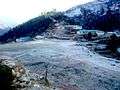
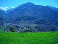
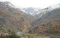
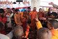
Photos of Bajura
References
External links
See also |