Kumaon division
For Kumaoni/Kumauni People see Kumauni People
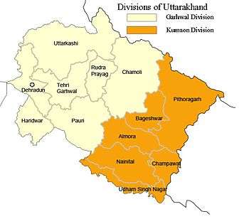
Kumaon (Hindi: कुमाऊं) or Kumaun is one of the two regions and administrative divisions of Uttarakhand, a mountainous state of northern India, the other being Garhwal. It includes the districts of Almora, Bageshwar, Champawat, Nainital, Pithoragarh, and Udham Singh Nagar. It is bounded on the north by Tibet, on the east by Nepal, on the south by the state of Uttar Pradesh, and on the west by the Garhwal region. The people of Kumaon are known as Kumaonis and speak the Kumaoni language.
It is home to a famous Indian Army regiment, the Kumaon Regiment.
Important towns of Kumaon are Haldwani, Nainital, Almora, Pithoragarh, Rudrapur, Kashipur, Pantnagar, Mukteshwar and Ranikhet. Nainital is the administrative centre of Kumaon Division and this is where the Uttarakhand high court is located.[1]
Etymology
Kumaon is believed to have been derived from "Kurmanchal", meaning land of the Kurmavatar (the tortoise incarnation of Lord Vishnu, the preserver according to Hinduism). The region of Kumaon is named after as such.
During the time of the British control of the region, between 1815 and 1857. It was also known as Kemaon.[2][3][4]
Geography

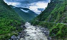
The Kumaon region consists of a large Himalayan tract, together with two submontane strips called the Terai and the Bhabar. The submontane strips were up to 1850 an almost impenetrable forest, given up to wild animals; but after 1850 the numerous clearings attracted a large population from the hills, who cultivated the rich soil during the hot and cold seasons, returning to the hills in the rains. The rest of Kumaon is a maze of mountains, part of the Himalaya range, some of which are among the loftiest known. In a tract not more than 225 km in length and 65 km in breadth there are over thirty peaks rising to elevations exceeding 5500 m.
The rivers like Gori, Dhauli, and Kali rise chiefly in the southern slope of the Tibetan watershed north of the loftiest peaks, amongst which they make their way down valleys of rapid declivity and extraordinary depth. The principal is the Sharda (Kali Ganga), the Pindari and Kailganga, whose waters join the Alaknanda. The river Sharda (Kali Ganga) forms the international boundary between India and Nepal. The pilgrim route currently used to visit Kailash-Mansarovar goes along this river and crosses into Tibet at Lipu Lekh pass.
The chief trees are the Chir Pine, Himalayan Cypress, Pindrow Fir, alder, sal or iron-wood, and saindan. Limestone, sandstone, slate, gneiss and granite constitute the principal geological formations. Mines of iron, copper, gypsum, lead and asbestos exist; but they are not thoroughly worked. Except in the submontane strips and deep valleys, the climate is mild. The rainfall of the outer Himalayan range, which is first struck by the monsoon, is double that of the central hills, in the average proportion of 2000 mm to 1000 mm. No winter passes without snow on the higher ridges, and in some years, it is universal throughout the mountain tract. Frosts, especially in the valleys, are often severe.
History
In the ancient period between 1300 and 1400 AD, after the disintegration of Katyuri kingdom of Uttarakhand, eastern region of Uttarakhand (Kumaon and Far-Western Region of Nepal which was a part of Uttarakhand then before modern day India was named), divided into eight different princely states i.e., Baijnath-Katyuri, Dwarhat, Doti, Baramandal, Askot, Sira, Sora, Sui (Kali kumaon). Later on, in 1581 AD after the defeat of Raika Hari Mall (maternal uncle of Rudra Chand) with the hand of Rudra Chand all these disintegrated parts came under King Rudra Chand and the whole region was as Kumaon.
Katyuri Raj
The Katyuri dynasty was of a branch of Kunindas origin and was founded by Vashudev Katyuri. Originally from Joshimath, during their reign they dominated lands of varying extent from the 'Katyur' (modern day Baijnath) valley in Kumaon, between 7th and 11th centuries AD, and established their capital at Baijnath in Bageshwar district, which was then known as Kartikeyapura and lies in the centre of 'Katyur' valley. Brahmadev mandi in Kanchanpur District of Nepal was established by Katyuri king Brahma Deo.
At their peak, the Katyuri kingdom extended from Nepal in the east to Kabul, Afghanistan in the west, before fragmenting into numerous principalities by the 12th century. They were displaced by the Chand Kings in the 11th century AD. Architectural remains of the Katyur dynasty's rule can be found in Baijnath and Dwarahat.
The Rajbar dynasty of Askot in Pithoragarh, was set up in 1279 AD, by a branch of the Katyuri Kings, headed by Abhay Pal Deo, who was the grandson of Katyuri king, Brahma Deo . The dynasty ruled the region till it became part of the British Raj through the treaty of Sighauli in 1816.
Chand Raj
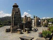
The Chand kingdom was established by Som Chand, who came here from Kannuaj near Allahabad, sometime in the 10th century,[5] and displaced the Katyuri Kings (कत्यूरी नरेश), originally from Katyur valley near Joshimath, who had been ruling the area from the 7th century AD. He continued to call his state Kurmanchal and established its capital in Champawat in Kali Kumaon called so, due to its vicinity to river Kali. Many temples built in this former capital city, during the 11th and 12th century exist today, this includes the Baleshwar and Nagnath temples.
They had brief skirmishes with the Rajput clans in Gangoli and Bankot then predominant there, the Mankotis of Mankot, the Pathanis of Attigaon-Kamsyar, Kalakotis and many other Khas Rajput Clans of the region. However they were able to establish their domain there.
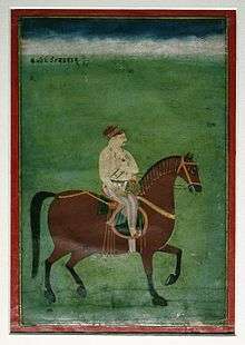
One of most powerful rulers of Chand dynasty was Baz Bahadur (1638–78) AD, who met Shahjahan in Delhi, and in 1655 joined forces with him to attack Garhwal, which was then under the King Pirthi Sah. Baz Bahadur subsequently captured the Terai region including Dehradun, which was thus separated from the Garhwal kingdom. Baz Bahadur extended his territory east to Karnali river. In 1672, Baz Bahadur started a poll tax, and its revenue was sent to Delhi as a tribute. Baz Bahadur also built the Golu Devata Temple, at Ghorakhal, near Bhimtal,[5] after Lord Golu, a general in his army, who died valiantly in battle.[6] He also built the famous Bhimeshwara Mahadev Temple at Bhimtal.[7]
Towards the end of the 17th century, Chand kings again attacked the Garhwal kingdom, and in 1688, Udyot Chand erected several temples at Almora, including Tripur Sundari, Udyot Chandeshwar, and Parbateshwar. To mark his victory over Garhwal and Doti, the Parbateshwar temple was renamed twice, to become the present Nanda Devi temple.[8] Later, Jagat Chand (1708–20), defeated the Raja of Garhwal and pushed him away from Srinagar (in Uttarakhand, not to be confused with the capital of present-day Indian Kashmir), and his kingdom was given to a Brahmin.[9] However, a subsequent king of Garhwal, Pradip Shah (1717–72), regained control over Garhwal and retained Dehra Dun till 1757, when Rohilla leader, Najib-ul-Daula, established himself there, though he was ousted soon by Pradip Shah.
Raikas Of Doti
Niranjan Malldeo was the founder of Doti Kingdom around the 13th century after a fall of Katyuris Kingdom. He was the son of Last Katyuris of united Katyuris kingdom. Kings of Doti were known as Raikas. Later on Raikas, after overthrow Khas Malla of Karnali Zone, were able to form a strong Raikas Kingdom in Far Western Region and Kumaun which was called Doti. So far, the historical evidence of following Raikas have been discovered; Niranjan Malldev (Founder of Doti Kingdom), Nagi Malla (1238 AD), Ripu Malla (1279 AD), Nirai Pal (1353 AD may be of Askot and his historical evidence of 1354 A.D has been found in Almoda), Nag Malla (1384 AD), Dhir Malla (1400 AD), Ripu Malla (1410 AD), Anand Malla (1430 AD), Balinarayan Malla (not known), Sansar Malla (1442 AD), Kalyan Malla (1443 AD), Suratan Malla (1478 AD), Kriti Malla(1482 AD), Prithivi Malla (1488 AD), Medini Jay Malla (1512 AD), Ashok Malla (1517 AD), Raj Malla (1539 AD), Arjun Malla/Shahi (not known but he was ruling Sira as Malla and Doti as Shahi), Bhupati Malla/Shahi (1558 AD), Sagaram Shahi (1567 AD), Hari Malla/Shahi (1581 AD Last Raikas King of Sira and adjoining part of Nepal ), Rudra Shahi (1630 AD), Vikram shahi (1642 AD), Mandhat shahi (1671 AD), Raghunath shahi (1690 AD), Hari shahi (1720 AD), Krishna Shahi (1760 AD), Deep shahi (1785 AD), Prithivi pati Shahi (1790 AD, 'he had fought several wars against British & Gokha attack on Doti Kingdom. The Kingdom finally defeated and became a part of Gorkha the present Nepal in 1814 AD') [10]
Nepalese invasion and its defeat

In the early 19th century, the region was ruled by the Nepalese Gorkha Kingdom. The people of Kumaon requested the British many times to help them overthrow Nepalese rule. According to folklore, when a British official was saved from the prison of the Tibetan Joongpong (Governor) of Taklakot in Tibet by some Kumaonis, he pursued their case with the Resident at Delhi and convinced him to attack the Gorkhas in Kumaon. Four thousand Kumaoni braves under Harsh Dev Joshi, a chieftain of the Chand king who was initially held responsible for the Gorkha invasion, joined the British. The British had so far been severely routed by the Gorkhas at several places (like the Battle of Jaithak and Malaun). But now the joint forces of Kumaonis and British struck the Gorkhas in the Battle of Syahidevi resulting in a complete rout of the Gorkhas. The Gorkha Subba (governor) fled, and so did their commanders. Almora was liberated.
The Gorkhas were defeated and the way for the liberation of Garhwal from the oppressive Gorkha rule was open. The British realised through this war the potential of military expertise of these hillmen. Inspired by their bravery, the British granted on the people of Kumaon the title of martial race. They recruited heavily from them, and the result was the Kumaon Regiment (earlier the Hyderabad Regiment which consisted mostly of Kumaonis).
British Raj

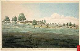
Later, the region was annexed by the British. In 1815 the Kumaon region was joined with the eastern half of the Garhwal region as a chief-commissionership on the non-regulation system, also known as the Kumaon Province.[11] It was governed for seventy years by three administrators, Mr. Traill, Mr. J. H. Batten and Sir Henry Ramsay.
There was widespread opposition against British rule in various parts of Kumaon. The Kumauni people especially Champawat District rose in rebellion against the British during the Indian Rebellion of 1857 under the leadership of the members like Kalu Singh Mahara.[12]
In 1891 the division was composed of the three districts of Kumaon, Garhwal and the Tarai; but the two districts of Kumaon and the Tarai were subsequently redistributed and renamed after their headquarters, Nainital and Almora.
Gandhiji's advent sounded a death knell for the British in Kumaon. People now aware of the excesses of British Raj became defiant of it and played an active part in the Indian Struggle for Independence.
Gandhiji was revered in these parts and on his call the struggle of Saalam Salia Satyagraha led by Ram Singh Dhoni was started which shook the very roots of British rule in Kumaon.[13] Many people lost their lives in the Saalam Satyagraha due to police brutality. Gandhiji named it the Bardoli of Kumaon an allusion to the Bardoli Satyagrah
Many Kumaonis also joined the Indian National Army led by Netaji Subhash Chandra Bose.
Martial race
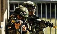
Kumaonis have been famous for their valour, their courage was legendary, their honour indomitable. The Kumaonis were never fully subjugated by the powerful Muslim dynasties of Delhi. Kumaonis were observed by the British, their valour was thus given recognition by the British and was included in the British Army. It is interesting to note that the 3rd Gorkha Rifles was known as the Keemaon battalion when it was formed and it included Kumaonis as well as the Garhwalis along with the Gorkhas. The Kumaonis, once accepted as a martial race, were themselves to be recruited in the Hyderabad regiment and displace the native troops, ultimately becoming the Kumaon Regiment after Independence of India. The Kumaon Regiment is one of the most decorated regiments of the Indian Army. The regiment traces its origins with the British Indian Army and has fought in various campaigns including the two world wars. After independence, the regiment has fought in all major conflicts involving India. They showed their exceptional courage in the Indo-Chinese War, the Battle of Rezang La has been proverbial for valour.
Language
Their Kumaoni language forms the Central subgroup of the Pahari languages.
Kumaoni is one of the 325 recognized Indian languages, and is spoken by over 2,360,000 (1998) people of Indian states of Uttarakhand - Almora, Nainital, Pithoragarh, Bageshwar, Champawat, Rudrapur (Udhamsingh Nagar) districts; Uttar pradesh; Assam; Bihar; Delhi; Madhya Pradesh; Maharashtra and Punjab, besides being spoken in some regions of Himachal Pradesh and Nepal.
Amongst its dialects, the Central Kumauni is spoken in Almora and northern Nainital, North-eastern Kumauni is in Pithoragarh, South-eastern Kumauni is in South-eastern Nainital, Western Kumauni is west of Almora and Nainital.
UNESCO’s Atlas of the World's Languages in Danger designates Kumaoni as language in the "unsafe" category and which requires consistent conservation efforts.[14]
Dialects of Kumaon region
In all, there are 20 dialects spoken in the Kumaon region, including, Johari, Majh Kumaiya, Danpuriya, Askoti, Sirali, Soryali, Chaugarkhyali, Kumaiya, Gangoli, Khasparjia, Phaldakoti, Pachhai, and Rauchaubhaisi.
Dialects of Kumaoni language
₳ Sijwali,Bora,Kaira, Bisht, Rawat,salal, Manral, Rajwar, Patwal, Kathayat, koranga,koshyari etc. at Chaukot % Salt all are Rajput
- Kali Kumaon, Central Kumaoni
- North-Eastern Kumaoni
- South-Eastern Kumaoni
- Western Kumaoni
- Askoti of Askot
- Bhabhri of Ramnagar [15]
- Chaugarkhiyali of Chaugarkha
- Danpuriya of Danpur
- Gangoli of Ganai-Gangoli (Gangolihat)
- Johari of Malla and Talla Johar
- Khasparjiya of Almora
- Kumaiyya of Champawat
- Pachhai of Pali-Pachhhau (Ranikhet, Dwarahat)
- Pashchimi
- Phaldakotiya of Phaldkot
- Rhau-Chaubyansi, (Nainital)
- Sirali of Sirakot (Didihat)
- Soriyali of Sor Valley (Pithoragarh)
- Baitada of Baitadi, Darchula and parts of Bajhang District in Nepal
- Dotiyali of Doti
Scholars also consider the heavy influence of Kumaoni on the Palpa language of Nepal.
- Tibeto-Burman (NOT dialects of Kumaoni; these non-Indo-European languages are indeed spoken in Kumaon)
Spoken in Upper Reaches of Kumaon Himalayas.
Kumaon Vani
With the aim to create a common platform for local communities of Supi in Uttarakhand, TERI launched 'Kumaon vani', a community radio service on 11 March 2010. Uttarakhand Governor Margaret Alva inaugurated the community radio station, the first in the state. The 'Kumaon Vani' aims to air programmes on environment, agriculture, culture, weather and education in the local language and with the active participation of the communities. The radio station covers a radius of 10 km reaching out to almost 2000 locals around Mukhteshwar[16]
See also
- Kumauni people
- List of Kumaonis
- Man-Eaters of Kumaon – a book
- Chand kings
- Martial race
- Garhwal division
- Iris kumaonensis (Iris from the region)
Further reading
- Upreti, Ganga Dutt (1894). Proverbs & folklore of Kumaun and Garhwal. Lodiana Mission Press.
- Oakley, E Sherman (1905). Holy Himalaya; the religion, traditions, and scenery of Himalayan province (Kumaon and Garwhal). Oliphant Anderson & Ferrier, London.
- of Kumaon, Raja Rudradeva; (Ed. with English tr. Haraprasada Shastri) (1910). Syanika sastra: or A Book on Hawking. Asiatic Society, Calcutta. Cite uses deprecated parameter
|coauthors=(help)
References
- ↑ Kumaon Information
- ↑ James Prinsep (Editor)Journal of the Asiatic Society of Bengal, Volume 6, Part 2 (1837), p. 653, at Google Books
- ↑ John McClelland Some inquiries in the province of Kemaon: relative to geology, and other branches of Natural Science (1835) at Google Books
- ↑ John Forbes Royle Illustrations of the botany and other branches of the natural history of the Himalayan Mountains and of the flora of Cashmere (1839), p. 108, at Google Books
- 1 2 History of Nainital District. The Imperial Gazetter of India. 1909. p. page 324.
- ↑ "Chitai Temple". Retrieved 3 October 2016.
- ↑ "Bhimtal". Retrieved 3 October 2016.
- ↑ "Almora Temples Uttaranchal - Uttarakhand Worldwide - Kumaon and Garhwal - Almora Temples". www.uttaranchal.org.uk. Retrieved 3 October 2016.
- ↑ History of Garhwal District. The Imperial Gazetteer of India. 1909. p. 165. Retrieved 3 October 2016.
- ↑ The Himalayan gazetteer -Atkinson
- ↑ Robert Montgomery Martin, History of the Possessions of the Honourable East India Company, Volume 1, pg. 107
- ↑ "The Tribune, Chandigarh, India - Dehradun Edition". Tribuneindia.com. Retrieved 2012-07-12.
- ↑ рдореНрдпрд░ рдкрд╣рд╛реЬ on 5 March 2010 (2010-03-05). "Salt Kranti in Uttarakhand: An Important Chapter of Freedom Movement". Merapahad.com. Retrieved 2012-07-12.
- ↑ Archived 17 February 2010 at the Wayback Machine.
- ↑ "Uttaranchal Dialects and Languages - Uttarakhand Worldwide - Kumaoni and Garhwali - Kumaon and Garhwal Dialects". Uttaranchal.org.uk. Retrieved 2012-07-12.
- ↑ Super Admin (2010-03-13). "TERI launches "Kumaon Vani" community radio service in Uttarakhand". News.oneindia.in. Retrieved 2012-07-12.
- A New History of Uttrakhand by Dr. Y.S. Kathoch
-
 This article incorporates text from a publication now in the public domain: Chisholm, Hugh, ed. (1911). "article name needed". Encyclopædia Britannica (11th ed.). Cambridge University Press.
External links
| Wikivoyage has a travel guide for Kumaon. |
- Official site of Kumaon Mandal Vikas Nigam (KMVN) for tourist information
- Brief history of Kumaon
- Temples Of Kumaon Himalayas
Coordinates: 29°36′N 79°42′E / 29.6°N 79.7°E