Crescent Hill, Louisville
|
Crescent Hill Historic District | |
|
Frankfort Avenue in Crescent Hill | |
  | |
| Location | Roughly bounded by Brownsboro and Lexington Rds, Peterson, Zorn, and Frankfort Aves., and Crabbs Lane, Louisville, Kentucky |
|---|---|
| Area | 590.6 acres (239.0 ha) |
| Architectural style | Colonial Revival, Classical Revival |
| NRHP Reference # | 82001556[1] |
| Added to NRHP | November 12, 1982 |
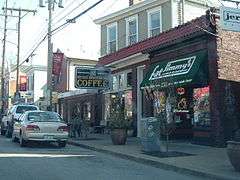
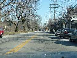
Crescent Hill is a neighborhood four miles (6 km) east of downtown Louisville, Kentucky USA. This area was originally called "Beargrass" because it sits on a ridge between two forks of Beargrass Creek. The boundaries of Crescent Hill are N Ewing Ave to the St. Matthews city limit (roughly Cannons Lane) by Brownsboro Road to Lexington Road. Frankfort Avenue generally bisects the neighborhood.
History
Development first began during the 1850s when the Louisville and Lexington turnpike (now Frankfort Avenue) and the Louisville and Frankfort railroad were built through the area. In 1853 a 38-acre (150,000 m2) fair grounds were built and were used to host the Agriculture and Technology fair, which had 20,000 visitors on one day in 1857. In 1883 the fair grounds were razed and St Joseph's Orphanage was built in its place.
In the late 19th century The City of Louisville annexed the old town of Crescent Hill. The Crescent Hill Community Council was incorporated in the early 1970s and became very active after the tornado of April 1974. In the early 1980s the CHCC formed the Peterson-Dumesnil House Foundation and purchased the house-301 South Peterson- from the Jefferson County Board of Education.
Attractions
Attractions in Crescent Hill include the Louisville Water Company Crescent Hill Reservoir, the Southern Baptist Theological Seminary, and the Peterson-Dumesnil House.
Demographics
As of 2000, the population of Crescent Hill was 7,566 , of which 91.4% are white, 4.2% are listed as other, 3.1% are black, & 1.3% are Hispanic. College graduates are 52.3% of the population, people without a high school degree are 8%. Females outnumber males 54.9% to 45.12%.
See also
References
- ↑ National Park Service (2010-07-09). "National Register Information System". National Register of Historic Places. National Park Service.
- ^ "Community Resource Network". Retrieved 2005-11-18.
External links
- Hill (Louisville, Ky.)/field/coveraa/mode/exact/conn/and/order/title/ad/asc/cosuppress/0 Images of Crescent Hill (Louisville, Ky.) in the University of Louisville Libraries Digital Collections
- Crescent Hill Community Council
- Street map of Crescent Hill
- "Crescent Hill: Ridge's Contour Gave Rise to Name; Mule Cars Gave Way to Electric Trolleys on Frankfort Avenue" — Article by Martha Elson of The Courier-Journal
- Southern Living: The South's Best Comeback Neighborhoods - Crescent Hill in Louisville, KY
 |
Clifton Heights | Brownsboro-Zorn | | |
| Clifton | |
St Matthews | ||
| ||||
| | ||||
| Cherokee Gardens |
| History |
|  |
|---|---|---|
| Geography |
| |
| Government |
| |
| Transportation | ||
| Other subject areas | ||
| Top subjects | ||
| National Historic Landmarks | ||
| Prominent suburbs (over 10K pop.) | ||
| ||
| Topics | |
|---|---|
| Lists by states |
|
| Lists by insular areas | |
| Lists by associated states | |
| Other areas | |
| |
Coordinates: 38°15′21″N 85°42′04″W / 38.25590°N 85.70110°W