Anchorage, Kentucky
| Anchorage, Kentucky | |
|---|---|
| City | |
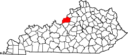
 Anchorage, Kentucky Location within the state of Kentucky | |
| Coordinates: 38°15′55″N 85°32′15″W / 38.26528°N 85.53750°WCoordinates: 38°15′55″N 85°32′15″W / 38.26528°N 85.53750°W | |
| Country | United States |
| State | Kentucky |
| County | Jefferson |
| Area | |
| • Total | 3.0 sq mi (7.9 km2) |
| • Land | 3.0 sq mi (7.9 km2) |
| • Water | 0.0 sq mi (0.0 km2) |
| Elevation | 712 ft (217 m) |
| Population (2000) | |
| • Total | 2,264 |
| • Density | 744.0/sq mi (287.3/km2) |
| Time zone | Eastern (EST) (UTC-5) |
| • Summer (DST) | EDT (UTC-4) |
| ZIP code | 40223 |
| Area code(s) | 502 |
| FIPS code | 21-01504 |
| GNIS feature ID | 0485930 |
| Website | www.cityofanchorage.org |
Anchorage is a home rule-class city[1] in eastern Jefferson County, Kentucky, United States. The population was 2,264 at the 2000 census. It is one of the wealthiest cities in Kentucky, and one of the more affluent suburbs of Louisville.
History
The land that is now Anchorage was a part of Isaac Hite's 1773 land grant, which awarded most of the land in today's Jefferson County to officers in the Virginia militia, in exchange for their service in the French and Indian War. Early maps refer to the area as Hite's Mill and it has also been known as Hobbs Station.[2] Part of his original grant now makes up the grounds of Central State Hospital and E. P. "Tom" Sawyer State Park.
The nautical name is a bit odd, considering the city is over twelve miles from the Ohio River. The origin is The Anchorage, the estate of riverboat captain and early resident James W. Goslee, and was chosen to honor him when the city incorporated in 1878, three years after his death. Tradition says that an anchor hanging inside the rim of a locomotive wheel at the center of town was taken by Goslee from his ship, the Matamora.
The Louisville and Frankfort Railroad (later purchased by the Louisville & Nashville Railroad) was built through the area in 1849. The development of an interurban rail line in 1901 allowed faster travel between Anchorage and Louisville, as well as other towns in the area.
The heavily-shaded city, with temperatures often noticeably cooler than in Downtown Louisville, became a popular location for summer homes for wealthy Louisvillians. One such resident was brewing magnate Isaac Wolfe Bernheim, still remembered locally for his philanthropy. In 1914, Bernheim commissioned the firm of Frederick Law Olmsted to design a plan for Anchorage, which would incorporate stone bridges and triangle intersections, similar to Olmsted's plans for Louisville's park system.

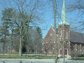
The city has long been known as home of some of the area's wealthiest citizens, though the large old estates have mostly been divided up and many new, still upscale, houses have been built in the area, especially since 1977. Part of the city is designated as the Anchorage Historic District, which was listed on the National Register of Historic Places in 1982.
Papa John's Pizza founder John Schnatter is a resident and owns about 6% of the land in Anchorage, including much of the city center. He restored an interurban rail station, three historic buildings and built a fourth in a similar style in the city's center, with plans to build a bank, an upscale restaurant, and a hiking trail, which opened as the Anchorage Trail in June 2008. In an interview, he told the Courier-Journal that his goal was purely to "preserve the city's character".[3]
Geography
Anchorage is located at 38°15′55″N 85°32′15″W / 38.26528°N 85.53750°W (38.265370, -85.537571).[4]
According to the United States Census Bureau, the city has a total area of 3.0 square miles (7.8 km2), of which 3.0 square miles (7.8 km2) is land and 0.33% is water.
Demographics
| Historical population | |||
|---|---|---|---|
| Census | Pop. | %± | |
| 1880 | 967 | — | |
| 1900 | 421 | — | |
| 1910 | 384 | −8.8% | |
| 1920 | 447 | 16.4% | |
| 1930 | 564 | 26.2% | |
| 1940 | 690 | 22.3% | |
| 1950 | 883 | 28.0% | |
| 1960 | 1,170 | 32.5% | |
| 1970 | 1,477 | 26.2% | |
| 1980 | 1,726 | 16.9% | |
| 1990 | 2,082 | 20.6% | |
| 2000 | 2,264 | 8.7% | |
| 2010 | 2,348 | 3.7% | |
| Est. 2015 | 2,420 | [5] | 3.1% |
As of the census[7] of 2000, there were 2,264 people, 729 households, and 643 families residing in the city. The population density was 744.0 people per square mile (287.5/km²). There were 750 housing units at an average density of 246.5 per square mile (95.3/km²). The racial makeup of the city was 97.13% White, 0.84% Black or African American, 1.33% Asian, 0.27% from other races, and 0.44% from two or more races. Hispanic or Latino of any race were 0.75% of the population.
There were 729 households out of which 52.4% had children under the age of 18 living with them, 81.9% were married couples living together, 3.7% had a female householder with no husband present, and 11.7% were non-families. 10.6% of all households were made up of individuals and 4.8% had someone living alone who was 65 years of age or older. The average household size was 3.09 and the average family size was 3.33.


In the city the population was spread out with 35.0% under the age of 18, 4.0% from 18 to 24, 20.8% from 25 to 44, 32.2% from 45 to 64, and 8.0% who were 65 years of age or older. The median age was 40 years. For every 100 females there were 99.1 males. For every 100 females age 18 and over, there were 95.5 males.
The median income for a household in the city was $133,969, and the median income for a family was $147,050. Males had a median income of $100,000 versus $47,188 for females. The per capita income for the city was $63,988. About 1.1% of families and 1.87% of the population were below the poverty line, including 1.2% of those under age 18 and 2.5% of those age 65 or over.
Education
Depending on location, families in Anchorage are provided K-12 education by either Jefferson County Public Schools, or by Anchorage Public School (K-8). Anchorage Public School is part of the Anchorage Independent Schools School District. Kelley Ransdell is the Superintendent of Schools.[8]
Notable people
Notable natives and residents of Anchorage include:
- Joan Osborne, singer-songwriter best known for "One of Us"
- John Schnatter, founder and CEO of Papa John's International, Inc
- Virginia Pearson, silent movie star
- David C. Novak, CEO of Yum! Brands Inc.
Climate
The climate in this area is characterized by hot, humid summers and generally mild to cool winters. According to the Köppen Climate Classification system, Anchorage has a humid subtropical climate, abbreviated "Cfa" on climate maps.[9]
See also
References
- ↑ "Summary and Reference Guide to House Bill 331 City Classification Reform" (PDF). Kentucky League of Cities. Retrieved December 30, 2014.
- ↑ Commonwealth of Kentucky. Office of the Secretary of State. Land Office. "Anchorage, Kentucky". Accessed 15 Jul 2013.
- ↑ Otts, Chris (2007-09-09). "Anchorage warms up to pizza magnate". Courier-Journal.
- ↑ "US Gazetteer files: 2010, 2000, and 1990". United States Census Bureau. 2011-02-12. Retrieved 2011-04-23.
- ↑ "Annual Estimates of the Resident Population for Incorporated Places: April 1, 2010 to July 1, 2015". Retrieved July 2, 2016.
- ↑ "Census of Population and Housing". Census.gov. Archived from the original on May 11, 2015. Retrieved June 4, 2015.
- ↑ "American FactFinder". United States Census Bureau. Archived from the original on 2013-09-11. Retrieved 2008-01-31.
- ↑ "Kentucky Department of Education Anchorage Independent". Kentucky Department of Education. Retrieved 2015-05-01.
- ↑ Climate Summary for Anchorage, Kentucky
External links
- Anchorage, Official city webpage
- Anchorage Trail—19th National Trails Symposium – Nov. 2008
- Anchorage, KY Climate Info, Weather Conditions and Forecast
- "Anchorage: Edward Hobbs' Actions Gave Town Strong Roots for Growth; River Captain Provided Name" — Article by John Ed Pearce of The Courier-Journal
 |
E. P. "Tom" Sawyer State Park | O' Bannon | | |
| Lyndon | |
Berrytown | ||
| ||||
| | ||||
| Middletown |
| History |
|  |
|---|---|---|
| Geography |
| |
| Government |
| |
| Transportation | ||
| Other subject areas | ||
| Top subjects | ||
| National Historic Landmarks | ||
| Prominent suburbs (over 10K pop.) | ||
| ||