Crawford, New York
| Crawford, New York | |
|---|---|
| Town | |
 Location in Orange County and the state of New York. | |
 Crawford, New York Location within the state of New York | |
| Coordinates: 41°36′N 74°18′W / 41.600°N 74.300°W | |
| Country | United States |
| State | New York |
| County | Orange |
| Government | |
| • Type | Town Council |
| • Town Supervisor | Charles E. Carnes (R) |
| • Town Council |
Members' List
|
| Area | |
| • Total | 40.2 sq mi (104.0 km2) |
| • Land | 40.1 sq mi (103.9 km2) |
| • Water | 0.0 sq mi (0.1 km2) |
| Elevation | 486 ft (148 m) |
| Population (2010) | |
| • Total | 9,316 |
| Time zone | Eastern (EST) (UTC-5) |
| • Summer (DST) | EDT (UTC-4) |
| FIPS code | 36-18916 |
| GNIS feature ID | 0978877 |

Crawford is a town in Orange County, New York, USA. The population was 9,316 at the 2010 census. The name comes from a settler who gave his name to a community in the hamlet now called Pine Bush.
The Town of Crawford is in the northwest corner of Orange County.
History
Crawford was originally settled around 1740. Crawford was originally part of the Town of Montgomery. Crawford was established as a town in 1823.
In 1813, the town considered itself the butter capital of the world.
In 1845, the town had a population of about 2,075 people.
Searsville, once an economic center and location of the town government, lost its status when the railroad came to the town through another area.
Geography
According to the United States Census Bureau, the town has a total area of 40.2 square miles (104 km2), of which, 40.1 square miles (104 km2) of it is land and 0.04 square miles (0.10 km2) of it (0.10%) is water.
The north town line is the border of Ulster County, New York, partly marked by the Shawangunk Kill, a small river.
NYS Route 52 and NYS Route 302 intersect in Pine Bush. NYS Route 17K crosses the south part of the town.
Demographics
| Historical population | |||
|---|---|---|---|
| Census | Pop. | %± | |
| 1830 | 2,019 | — | |
| 1840 | 2,075 | 2.8% | |
| 1850 | 1,912 | −7.9% | |
| 1860 | 2,003 | 4.8% | |
| 1870 | 2,024 | 1.0% | |
| 1880 | 1,951 | −3.6% | |
| 1890 | 1,876 | −3.8% | |
| 1900 | 1,778 | −5.2% | |
| 1910 | 1,659 | −6.7% | |
| 1920 | 1,507 | −9.2% | |
| 1930 | 1,800 | 19.4% | |
| 1940 | 1,786 | −0.8% | |
| 1950 | 2,410 | 34.9% | |
| 1960 | 2,574 | 6.8% | |
| 1970 | 3,896 | 51.4% | |
| 1980 | 4,910 | 26.0% | |
| 1990 | 6,394 | 30.2% | |
| 2000 | 7,875 | 23.2% | |
| 2010 | 9,316 | 18.3% | |
| Est. 2014 | 9,236 | [1] | −0.9% |
As of the census[3] of 2000, there were 7,875 people, 2,707 households, and 2,133 families residing in the town. The population density was 196.3 people per square mile (75.8/km²). There were 2,851 housing units at an average density of 71.1 per square mile (27.4/km²). The racial makeup of the town was 95.59% White, 1.19% African American, 0.08% Native American, 0.76% Asian, 0.01% Pacific Islander, 1.16% from other races, and 1.21% from two or more races. Hispanic or Latino of any race were 5.13% of the population.
There were 2,707 households out of which 42.3% had children under the age of 18 living with them, 65.8% were married couples living together, 8.2% had a female householder with no husband present, and 21.2% were non-families. 17.4% of all households were made up of individuals and 7.2% had someone living alone who was 65 years of age or older. The average household size was 2.90 and the average family size was 3.29.
In the town the population was spread out with 30.3% under the age of 18, 6.1% from 18 to 24, 30.2% from 25 to 44, 24.1% from 45 to 64, and 9.2% who were 65 years of age or older. The median age was 36 years. For every 100 females there were 98.3 males. For every 100 females age 18 and over, there were 94.2 males.
The median income for a household in the town was $57,063, and the median income for a family was $63,722. Males had a median income of $42,200 versus $30,763 for females. The per capita income for the town was $21,614. About 2.7% of families and 4.0% of the population were below the poverty line, including 3.5% of those under age 18 and 7.0% of those age 65 or over.
Communities and locations in Crawford
- Bullville – A hamlet in the south part of Crawford on NY-17K at the intersection of NY-302.
- Collabar – A hamlet in the south part of Crawford on NY-17K.
- Hopewell – A former community in the town.
- Pine Bush (formerly called "Crawford') – The hamlet of Pine Bush is in the town's northwest corner at the junction of NY-52 and NY-302.
- Searsville (formerly "Searsburg") – A hamlet on County Road 17, east of Thompson Ridge.
- Thompson Ridge – A hamlet on NY-302 south of Pine Bush. The John I. Crawford Farm was listed on the National Register of Historic Places in 1998.[4]
- Van Keuren – A hamlet on NY-302 between Pine Bush and Thompson Ridge.
Coordinates: 41°36′N 74°18′W / 41.600°N 74.300°W
References
- ↑ "Annual Estimates of the Resident Population for Incorporated Places: April 1, 2010 to July 1, 2014". Retrieved June 4, 2015.
- ↑ "Census of Population and Housing". Census.gov. Archived from the original on May 11, 2015. Retrieved June 4, 2015.
- ↑ "American FactFinder". United States Census Bureau. Archived from the original on 2013-09-11. Retrieved 2008-01-31.
- ↑ National Park Service (2010-07-09). "National Register Information System". National Register of Historic Places. National Park Service.
External links
Municipalities and communities of Orange County, New York, United States | ||
|---|---|---|
| Cities | 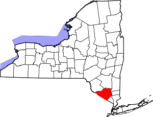 | |
| Towns | ||
| Villages | ||
| CDPs | ||
| Other hamlets | ||