Hamptonburgh, New York
| Hamptonburgh, New York | |
|---|---|
| Town | |
|
Town hall | |
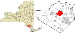 Location in Orange County and the state of New York. | |
 Hamptonburgh, New York Location within the state of New York | |
| Coordinates: 41°27′15″N 74°14′48″W / 41.45417°N 74.24667°W | |
| Country | United States |
| State | New York |
| County | Orange |
| Government | |
| • Type | Town Council |
| • Town Supervisor | Robert S. Jankowski (R) |
| • Town Council |
Members' List
|
| Area | |
| • Total | 27.0 sq mi (69.8 km2) |
| • Land | 26.8 sq mi (69.4 km2) |
| • Water | 0.2 sq mi (0.5 km2) |
| Elevation | 384 ft (117 m) |
| Population (2010) | |
| • Total | 5,561 |
| • Density | 210/sq mi (80/km2) |
| Time zone | Eastern (EST) (UTC-5) |
| • Summer (DST) | EDT (UTC-4) |
| FIPS code | 36-31907 |
| GNIS feature ID | 0979042 |

Hamptonburgh is a town located in the northern part of Orange County, New York, United States. The population was 5,561 at the 2010 census. It was named by an early settler, William Bull, for his place of birth — Wolverhampton.[1]
The Town of Hamptonburgh is in the north central part of Orange County.
History
The town was part of patent of 1703, assigned to Christopher Denn and others.
The town was established in 1830 from parts of the Towns of Blooming Grove, Goshen, and Montgomery, including land which previously belonged to Loyalist Fletcher Mathews (brother of David Mathews who was Mayor of New York City during its occupation by the British during the American Revolution).
According to "An Outline History of Orange County" by Samuel Watkins Eager p. 378 Campbell Hall was named for Colonel Campbell who was a Scotchman, had 2 sons, and when the war of the Revolution commenced, one sided with England; the other with his adopted country. The tory brother would not speak with his republican relative. The sentiments of this brother were changed by the happy results of the revolution.
Geography
According to the United States Census Bureau, the town has a total area of 27.0 square miles (70 km2), of which, 26.8 square miles (69 km2) of it is land and 0.2 square miles (0.52 km2) of it (0.67%) is water.
NY-207 and NY-416 intersect west of Campbell Hall.
Demographics
| Historical population | |||
|---|---|---|---|
| Census | Pop. | %± | |
| 1830 | 1,365 | — | |
| 1840 | 1,379 | 1.0% | |
| 1850 | 1,343 | −2.6% | |
| 1860 | 1,295 | −3.6% | |
| 1870 | 1,224 | −5.5% | |
| 1880 | 1,143 | −6.6% | |
| 1890 | 1,129 | −1.2% | |
| 1900 | 1,072 | −5.0% | |
| 1910 | 1,168 | 9.0% | |
| 1920 | 1,104 | −5.5% | |
| 1930 | 1,130 | 2.4% | |
| 1940 | 1,086 | −3.9% | |
| 1950 | 1,272 | 17.1% | |
| 1960 | 1,695 | 33.3% | |
| 1970 | 2,204 | 30.0% | |
| 1980 | 2,945 | 33.6% | |
| 1990 | 3,910 | 32.8% | |
| 2000 | 4,686 | 19.8% | |
| 2010 | 5,561 | 18.7% | |
| Est. 2014 | 5,522 | [2] | −0.7% |
According to the Census Bureau's 2008-2012 American Community Survey(ACS), there were 5,542 people, 1,718 households, and 1,338 families residing in the town. The population density was 175.0 people per square mile (67.6/km²). There were 1,532 housing units at an average density of 57.2 per square mile (22.1/km²). The racial makeup of the town was 92.3% White, 3.9% African American, 0.0% Native American, 2.6% Asian, and 1.1% from two or more races. Hispanic or Latino of any race were 6.5% of the population.
There were 1,338 family households out of which 36.3% had children under the age of 18 living with them, 76.2% were married couples living together, 5.1% had a female householder with no husband present, 3.8% had a male householder with no wife present, and 14.9% were non-families. 12.9% of all households were made up of individuals and 4.2% had someone living alone who was 65 years of age or older. The average household size was 3.43 and the average family size was 3.78.
In the town the population was spread out with 24.3% under the age of 18, 13% from 18 to 24, 17.7% from 25 to 44, 29.8% from 45 to 64, and 15.1% who were 65 years of age or older. The median age was 42.7 years. For every 100 females there were 104.4 males.
The Census Bureau's 2008-2012 American Community Survey showed that (in 2012 inflation-adjusted dollars) median household income was $96,693 (with a margin of error of +/- $9,466) and the median family income was $106,389 (+/- $10,958). Males had a median income of $68,482 (+/- $17,326) versus $54,405 (+/- $9,542) for females. The per capita income for the village was $33,903 (+/- $2,665). About 0.7% of families and 2% of the population were below the poverty line, including 0.7% of those under age 18 and 3.4% of those age 65 or over.

Economy
Hamptonburgh is a wider area, but the main center of Hamptonburgh is Campbell Hall. Campbell Hall is home to America's first butter factory. It is also the location of the Otterkill Fire Department and the Campbell Hall post office. Its economy is derived from a number of sources: The General Store, Campbell Hall Salvage, American Fence, a Service Station, the Bull's Head Inn, and a number of horse and dairy farms. Campbell Hall also is home to Orange AHRC, the Otterkill Golf and Country Club, and a Metro-North train station.
Communities and locations in Hamptonburgh
| Wikimedia Commons has media related to Hamptonburgh, New York. |
- Burnside – Formerly a hamlet with its own post office, it is now serviced by the Campbell Hall post office. It is located near the town line east of Campbell Hall.
- Campbell Hall – The hamlet of Campbell Hall is the principal community in the town and is located on New York State Route 207.
- Campbell Hall Junction – A location west of Campbell Hall at the junction of NY-207 and NY-416.
- Hamptonburgh – The hamlet of Hamptonburgh is located south of Campbell Hall at the intersection of County Roads 8 and 51.
- Kipps – A location near the south town line.
- LaGrange – A location southwest of Campbell Hall on NY-207.
- Neelytown – A location near the north town line.
- Stony Ford – A location near the west town line.
References
- ↑ Gannett, Henry (1905). The Origin of Certain Place Names in the United States. Govt. Print. Off. p. 148.
- ↑ "Annual Estimates of the Resident Population for Incorporated Places: April 1, 2010 to July 1, 2014". Retrieved June 4, 2015.
- ↑ "Census of Population and Housing". Census.gov. Retrieved June 4, 2015.
Municipalities and communities of Orange County, New York, United States | ||
|---|---|---|
| Cities | 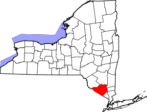 | |
| Towns | ||
| Villages | ||
| CDPs | ||
| Other hamlets | ||
Coordinates: 41°26′06″N 74°15′37″W / 41.43500°N 74.26028°W