Cornus, Aveyron
| Cornus | ||
|---|---|---|
|
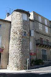
Tour de l'Aiguillon | ||
| ||
 Cornus | ||
|
Location within Occitanie region  Cornus | ||
| Coordinates: 43°54′11″N 3°10′46″E / 43.9031°N 3.1794°ECoordinates: 43°54′11″N 3°10′46″E / 43.9031°N 3.1794°E | ||
| Country | France | |
| Region | Occitanie | |
| Department | Aveyron | |
| Arrondissement | Millau | |
| Canton | Cornus | |
| Intercommunality | Larzac-Templier Causses et Vallées | |
| Government | ||
| • Mayor (2008–2014) | Christophe Laborie (PR) | |
| Area1 | 92.74 km2 (35.81 sq mi) | |
| Population (2008)2 | 514 | |
| • Density | 5.5/km2 (14/sq mi) | |
| Time zone | CET (UTC+1) | |
| • Summer (DST) | CEST (UTC+2) | |
| INSEE/Postal code | 12077 / 12540 | |
| Elevation |
496–887 m (1,627–2,910 ft) (avg. 630 m or 2,070 ft) | |
|
1 French Land Register data, which excludes lakes, ponds, glaciers > 1 km² (0.386 sq mi or 247 acres) and river estuaries. 2 Population without double counting: residents of multiple communes (e.g., students and military personnel) only counted once. | ||
.svg.png)
Cornus is a commune in the Aveyron department in southern France.
Geography
The commune lies on the causse du Larzac.
The village lies in the valley of the Dèvre, a tributary of the Sorgues, which has its source in the commune.
Population
| Historical population | ||
|---|---|---|
| Year | Pop. | ±% |
| 1962 | 540 | — |
| 1968 | 513 | −5.0% |
| 1975 | 510 | −0.6% |
| 1982 | 434 | −14.9% |
| 1990 | 345 | −20.5% |
| 1999 | 364 | +5.5% |
| 2008 | 514 | +41.2% |
See also
References
| Wikimedia Commons has media related to Cornus (Aveyron). |
This article is issued from Wikipedia - version of the 2/11/2016. The text is available under the Creative Commons Attribution/Share Alike but additional terms may apply for the media files.