Peyrusse-le-Roc
| Peyrusse-le-Roc | ||
|---|---|---|
|
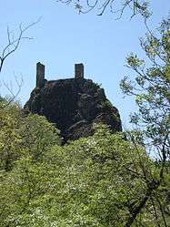
The towers of Peyrusse-le-Roc | ||
| ||
 Peyrusse-le-Roc | ||
|
Location within Occitanie region  Peyrusse-le-Roc | ||
| Coordinates: 44°29′48″N 2°08′29″E / 44.4967°N 2.1414°ECoordinates: 44°29′48″N 2°08′29″E / 44.4967°N 2.1414°E | ||
| Country | France | |
| Region | Occitanie | |
| Department | Aveyron | |
| Arrondissement | Villefranche-de-Rouergue | |
| Canton | Montbazens | |
| Intercommunality | Plateau de Montbazens | |
| Government | ||
| • Mayor (2008–2014) | Francis Savignac | |
| Area1 | 13.81 km2 (5.33 sq mi) | |
| Population (2008)2 | 213 | |
| • Density | 15/km2 (40/sq mi) | |
| Time zone | CET (UTC+1) | |
| • Summer (DST) | CEST (UTC+2) | |
| INSEE/Postal code | 12181 / 12220 | |
| Elevation |
233–496 m (764–1,627 ft) (avg. 450 m or 1,480 ft) | |
|
1 French Land Register data, which excludes lakes, ponds, glaciers > 1 km² (0.386 sq mi or 247 acres) and river estuaries. 2 Population without double counting: residents of multiple communes (e.g., students and military personnel) only counted once. | ||

Peyrusse-le-Roc is a commune in the Aveyron department in southern France.
The Château Inférieur is a ruined castle which was taken by the English in 1163 and occupied by Simon de Montfort.
Population
| Historical population | ||
|---|---|---|
| Year | Pop. | ±% |
| 1962 | 392 | — |
| 1968 | 392 | +0.0% |
| 1975 | 383 | −2.3% |
| 1982 | 374 | −2.3% |
| 1990 | 288 | −23.0% |
| 1999 | 229 | −20.5% |
| 2008 | 213 | −7.0% |
See also
References
| Wikimedia Commons has media related to Peyrusse-le-Roc. |
This article is issued from Wikipedia - version of the 3/15/2016. The text is available under the Creative Commons Attribution/Share Alike but additional terms may apply for the media files.