Prades-Salars
| Prades-Salars | |
|---|---|
|
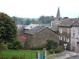
The church and surrounding buildings in Prades-Salars | |
 Prades-Salars | |
|
Location within Occitanie region  Prades-Salars | |
| Coordinates: 44°15′50″N 2°47′07″E / 44.2639°N 2.7853°ECoordinates: 44°15′50″N 2°47′07″E / 44.2639°N 2.7853°E | |
| Country | France |
| Region | Occitanie |
| Department | Aveyron |
| Arrondissement | Rodez |
| Canton | Pont-de-Salars |
| Intercommunality | Pays de Salars |
| Government | |
| • Mayor (2008–2014) | Jacques Garde |
| Area1 | 30.55 km2 (11.80 sq mi) |
| Population (2008)2 | 283 |
| • Density | 9.3/km2 (24/sq mi) |
| Time zone | CET (UTC+1) |
| • Summer (DST) | CEST (UTC+2) |
| INSEE/Postal code | 12188 / 12290 |
| Elevation |
769–984 m (2,523–3,228 ft) (avg. 800 m or 2,600 ft) |
|
1 French Land Register data, which excludes lakes, ponds, glaciers > 1 km² (0.386 sq mi or 247 acres) and river estuaries. 2 Population without double counting: residents of multiple communes (e.g., students and military personnel) only counted once. | |
Prades-Salars (Occitan: Pradas) is a commune in the Aveyron department in southern France.
Population
| Historical population | ||
|---|---|---|
| Year | Pop. | ±% |
| 1962 | 360 | — |
| 1968 | 401 | +11.4% |
| 1975 | 365 | −9.0% |
| 1982 | 316 | −13.4% |
| 1990 | 320 | +1.3% |
| 1999 | 293 | −8.4% |
| 2008 | 283 | −3.4% |
See also
References
| Wikimedia Commons has media related to Prades-Salars. |
This article is issued from Wikipedia - version of the 3/9/2015. The text is available under the Creative Commons Attribution/Share Alike but additional terms may apply for the media files.