Condom-d'Aubrac
| Condom-d'Aubrac | |
|---|---|
|
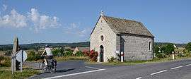
The chapel of Bastide | |
 Condom-d'Aubrac | |
|
Location within Occitanie region  Condom-d'Aubrac | |
| Coordinates: 44°36′16″N 2°51′58″E / 44.6044°N 2.8661°ECoordinates: 44°36′16″N 2°51′58″E / 44.6044°N 2.8661°E | |
| Country | France |
| Region | Occitanie |
| Department | Aveyron |
| Arrondissement | Rodez |
| Canton | Saint-Chély-d'Aubrac |
| Government | |
| • Mayor (2008–2014) | Geneviève Gasq-Bares |
| Area1 | 46.08 km2 (17.79 sq mi) |
| Population (2008)2 | 319 |
| • Density | 6.9/km2 (18/sq mi) |
| Time zone | CET (UTC+1) |
| • Summer (DST) | CEST (UTC+2) |
| INSEE/Postal code | 12074 / 12470 |
| Elevation |
465–1,440 m (1,526–4,724 ft) (avg. 950 m or 3,120 ft) |
|
1 French Land Register data, which excludes lakes, ponds, glaciers > 1 km² (0.386 sq mi or 247 acres) and river estuaries. 2 Population without double counting: residents of multiple communes (e.g., students and military personnel) only counted once. | |
Condom-d'Aubrac is a commune in the Aveyron department in southern France.
Population
| Historical population | ||
|---|---|---|
| Year | Pop. | ±% |
| 1793 | 1,014 | — |
| 1800 | 1,120 | +10.5% |
| 1841 | 1,164 | +3.9% |
| 1846 | 1,162 | −0.2% |
| 1851 | 1,034 | −11.0% |
| 1856 | 967 | −6.5% |
| 1861 | 951 | −1.7% |
| 1866 | 989 | +4.0% |
| 1872 | 1,067 | +7.9% |
| 1876 | 1,252 | +17.3% |
| 1881 | 1,137 | −9.2% |
| 1886 | 1,041 | −8.4% |
| 1891 | 1,048 | +0.7% |
| 1896 | 948 | −9.5% |
| 1901 | 860 | −9.3% |
| 1906 | 942 | +9.5% |
| 1911 | 776 | −17.6% |
| 1921 | 668 | −13.9% |
| 1926 | 619 | −7.3% |
| 1931 | 610 | −1.5% |
| 1936 | 588 | −3.6% |
| 1946 | 577 | −1.9% |
| 1954 | 509 | −11.8% |
| 1962 | 512 | +0.6% |
| 1968 | 471 | −8.0% |
| 1975 | 382 | −18.9% |
| 1982 | 336 | −12.0% |
| 1990 | 349 | +3.9% |
| 1999 | 350 | +0.3% |
| 2008 | 319 | −8.9% |
See also
References
| Wikimedia Commons has media related to Condom-d'Aubrac. |
This article is issued from Wikipedia - version of the 3/9/2015. The text is available under the Creative Commons Attribution/Share Alike but additional terms may apply for the media files.