Chamhad
| Chamad | |
|---|---|
| Union Council | |
|
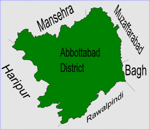
Chamad is located in Abbottabad District | |
| Coordinates: 34°07′00″N 73°05′00″E / 34.11667°N 73.08333°ECoordinates: 34°07′00″N 73°05′00″E / 34.11667°N 73.08333°E | |
| Country |
|
| Province | Khyber Pakhtunkhwa |
| District | Abbottabad |
| Tehsil | Abbottabad |
| Government | |
| • Nazim | Falasfar Khan[1] |
| • Naib Nazim | Muhammad Shamraiz Khan |
| Population | |
| • Total | 17.824 |
Chamad (also known as Chamhad) is one of the 51 Union Councils (subdivisions) of Abbottabad District in the Khyber Pakhtunkhwa province of Pakistan.[2]
Location
Chamad is located at 34°7'0N 73°4'60E, in the west of the district where it forms part of Abbottabad's border with Haripur District. It has an average elevation of 870 metres (2857 feet). Neighbouring settlements include Patian, Baghdara and Talhad and Sarbangala
Subdivisions
The Union Council is subdivided into the following areas: Khani Thathiara, Shadial, Chamhad, Fateh Bandi, Sarbangala, Chamak Mera, Bagh Darah, Bermgali, Bisala, Mohal, Baln Seri, Bain Noora, Bain Gojra, Bothiala, Jattal, Baghati, Thana, Kasaki Khurd, Kasaki Kalan, Daroparh and Bhoraj.[1]
References
- 1 2 Chamhad Union Council
- ↑ Administrative Units of District Abbottabad Archived April 3, 2007, at the Wayback Machine.
Khorian, Batangi,Mangal Darra,Sarbangala,Barangalli,Beesala,Bucha Galli,
External links
This article is issued from Wikipedia - version of the 11/19/2016. The text is available under the Creative Commons Attribution/Share Alike but additional terms may apply for the media files.