Nathia Gali
| Nathia Gali | |
|---|---|
| Union council | |
|
Location of Nathia Gali union council (highlighted in red) within Abbottabad district | |
 | |
 Nathia Gali | |
| Coordinates: 34°04′N 73°23′E / 34.067°N 73.383°E | |
| Country |
|
| Province | Khyber Pakhtunkhwa |
| District | Abbottabad |
| Tehsil | Abbottabad |
| Government | |
| • Nazim | Sardar Gulfaraz[1] |
| • Naib Nazim | Sardar Zahoor Ahmed |


Nathia Gali or Nathiagali (Pashto: نتھیا گلی, Urdu: نتھیا گلی) is a mountain resort town or hill station in Abbottabad District of Khyber Pakhtunkhwa, Pakistan. It is a part of the Galyat range, where several hill-stations are situated, closely connected to each other, and with their names mostly ending in 'Gali'. Nathiagali is known for its scenic beauty, hiking tracks and pleasant weather, which is much cooler than the rest of the Galyat due to it being at a greater altitude. It is situated 34 kilometers at one hour's drive away from both Murree and Abbottabad, lying midway between these two places. The drive time from Islamabad is usually about two hours, unless there is a lot of traffic.[2][3]
History
During British rule Nathia Gali, then part of Abbottabad tehsil of Hazara District, served as the summer headquarters of the Chief Commissioner of the (then) Peshawar division of the Punjab.[4] The town along with Dunga Gali constituted a notified area under the Punjab Municipalities Act, 1891. The income in 1903-4 was Rs. 3,000 chiefly derived from a house tax, whilst expenditure was Rs. 1,900.[2]
Climate
The weather of Nathiagali remains cool, pleasant and foggy in summers (1 May to 31 August). During the monsoon season (1 July to 16 September), rain is expected almost every day. Cold winds start to chill the weather in autumn. winters (1 November to 28 February) are very cold and chilly. In December and January, heavy snowfall occurs here. The weather remains cold in spring. Here most comfortable weather is the summer season.[5]
Transportation
The town is connected to Abbottabad and Murree by Nathiagali road. Public transport runs daily from Abbottabad and Rawalpindi to Nathiagali.
In December and January, heavy snowfall occurs in this area and the road leading to Nathiagali is blocked due to heavy snow.
Communication
Nathiagali is covered by all GSM operators. Land line phone service is also available here.
Accommodation
Some Hotels, Rest houses and Cottages equipped with most facilities are available here for the tourists. During summers ( May to August) their rates become high.
A small market also exists here where all the basic necessities of life are available for the people.
Tourism
Nathia Gali town also serves as the administrative centre of Nathia Gali Union Council. It is today located in what is the Abbottabad District, Khyber Pakhtunkhwa. At 2,500 m (8,200 ft), it is a popular tourist resort in the summer months. It is forested with pine,cedar,oak walnut and also oak and maple trees.
During the summer, Nathia Gali is relatively popular amongst tourists, but due to its limited area and availability of property, it is not thronged by as many people as the hill-station Murree, which is only an hour away, even though it has more to offer in terms of recreation. Nathiagali is known for a beautiful trek that leads to Thandiani that passes through Dagri naka. [6]
Scenery
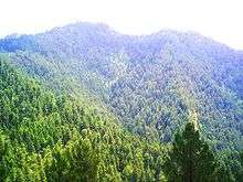
The natural scenery is highly attractive. Nathia Gali is famous for its lush green meadows, deep forests of oak, cedar and pine, where fog in July/August present a glory. In winter snowfall adds to the scene. Nathia Gali boasts a nice church, St. Matthew's, a remnant from the British period and made entirely of wood. It is situated at the edge of the mountain with a nice panorama towards Kashmir. Nathia Gali has a mini bazar. Mukshpuri and Miranjani are two nearby high peaks. On a clear day, the Nanga Parbat can been seen in the distance.
Wildlife
The Nathia Gali region is home to various species of birds, insects, butterflies and other animals. The World Wildlife Fund has an office in the Galliat and has assisted in the breeding and reintroduction of the species of the near-extinct common hill leopard in the forests of the Ayubia National park, right by Dungagali and Nathia Gali. This area was thought to be a perfect habitat for them but according to local reports they frequently came out of the forest after cattle of the local villagers and were occasionally shot. Packs of pi-dogs which were previously considered to be a night-time menace can no longer be seen anywhere in the Galliat; it is thought that most have been killed by leopards. In the summer of 2006, several women were found dead in the deep valleys of Galliat with wounds from attacks. A large leopard was caught and eventually shot. His body has been stuffed and kept in the Dunga Gali Wildlife Museum, where he has been named the 'Ghost of Galyat'. However, despite their reputation, these leopards are rarely spotted.
Horses are a common sight during summer months and are offered to children and adults alike for rides at rates that are often negotiable. The common hill rhesus monkeys can often be seen. Previously known to be a little shy, they have reportedly become more aggressive in recent years. This may be due to increased interaction with tourists, who often tease these monkeys or try to catch them. Monkeys often come up to guesthouses and hotels in search of snacks and can be quite noisy and playful. Visitors are advised to sun their bedding on arrival to get rid of bed-bugs, and to keep repellents and pesticides for insects as these have a tendency to show up a lot, especially in old homes, and in the monsoon season.
Subdivisions

The Union Council of Nathia Gali is divided into the following areas: Bagan, Donga Gali, Jhansa, Keri Sarafali, Keri Raiki, Lassan, Malach, Nathiagali and Pasala.[1]
Ethnic groups
The main tribe of Nathia Gali is the Karlal tribe, minority of Dhunds (who now call themselves 'Dhund-Abbasis'), Malechas and other similar hill people are also settled here.[7] they are a kin to the people of Murree nearby and speak the Hindko language. Until well into the 1960s, most of these tribes and clans were mostly living rather basic and primitive lives, due to lack of educational and employment opportunities[8] and most of them had to seek jobs and education down in the plains and cities such as Rawalpindi, Lahore, Peshawar and even as far away as Karachi; but in more recent times, with economic development, many of them are either employed locally in the tourism industry or in various jobs and businesses in the Abbottabad area. The popular personalities of Nathia Gali are Sardar Jeenda Khan, Sardar Babu Lal Khan, Sardar Ahmad Nawaz, Sardar Idrees, Sardar Khalil ur Rehman (late), Sardar Malik Ayoob (late) <History of Karlal>
Gallery


See also
References
- 1 2 Nathia Gali Union Council
- 1 2 Nathia Gali - Imperial Gazetteer of India, v. 18, p. 415
- ↑ Nathiagali, Publisher: Tourism Development Corporation of Punjab (TDCP). Retrieved 27 October 2012
- ↑ These areas later became part of the then North West Frontier Province from 1901 onwards
- ↑ Nathiagali weather forecast, Publisher: nathiagali.com . Retrieved 10 November 2012.
- ↑ http://www.khyberpakhtunkhwa.gov.pk/Attraction/Galyat.php
- ↑ They are akin to the people of Murree area nearby, in Punjab, a continuation of the Galyat range
- ↑ Hazara Divisional Report, 1991-1992, Pub. Govt. of NWFP, 1993, pp. 45-46
External links
| Wikimedia Commons has media related to Nathia Gali. |
- Places to Visit in Abbottabad
- Miranjani Trek by Shaikh Muhammad Ali
- The Pipe Line Trek by Shaikh Muhammad Ali
- Mokshpuri Trek by Shaikh Muhammad Ali
- http://www.nathiagali.com
-
 Murree travel guide from Wikivoyage
 - Nathiagali Pictures
- Governor's House
- Sarhad Tourism Corporation, Government of Khyber Pakhtunkhwa, Pakistan
- http://www.nathiagali.com/?page_id=16
- Hotels in Nathiagali (reservation)
- Hotel in Nathiagali (book your corporate event)
- FAQ about Nathiagali (Question Answers about Nathiagali)
Coordinates: 34°04′05″N 73°23′32″E / 34.06806°N 73.39222°E