Baldheri
| Baldheri | |
|---|---|
| Union Council | |
|
Baldehri is located in Abbottabad District | |
| Coordinates: 34°15′N 73°12′E / 34.250°N 73.200°E | |
| Country |
|
| Province | Khyber-Pakhtunkhwa |
| District | Abbottabad |
| Tehsil | Abbottabad |
| Government | |
| • Nazim | Asad Khan[1] |
| • Naib Nazim | Saqlain Sarwar |
| Population | |
| • Total | 15,744 |
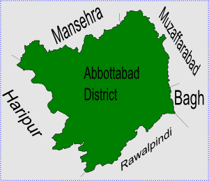
Baldheri is one of the 51 union councils of Abbottabad District in Khyber-Pakhtunkhwa province of Pakistan,[2] the union council of Baldheri is named after the main village of the area. The population of Baldheri Union Council is 14,796.[3]
Location
The village of Baldheri itself is situated at 34°15'0N 73°12'0E[4] which is about 11 km east of Abbottabad city centre on the route towards Mansehra on the main Mansehra Road. Geographically Mansehra lies directly to the north, but the hilly terrain results in these winding roads, hence Baldheri is en route to Mansehra from Abbottabad city.
Baldheri has an average elevation of 1143 metres (3753 feet). The area covered by Baldheri union council, is between Ferozabad village to Tanan Village and Mangal to Halmaira.
Subdivisions
The Union Council of Baldheri is subdivided into the following areas: Baldheri, Gojri, Hal Maira Uta, Hal Maira Tarta, Jalalpura, More Kalan, Sajikot and Tannan[1]
Villages
The Union Council of Baldheri consists of the following villages:
- Baldheri
- Gojri
- Halmaira
- Mangal
- Morkalaan
- Neelay Pair
- Qalandarabad
- Sajikot
- Ferozabad
- Tannan
- Tarhana Malik
- Tarhana Malyar
Jadoons (Hassazai and Mansur), Maliks(Abbasis) of Gojri and Awans of Sajikot, Halmaira Utla are the main tribe of the U/C Baldheri. Other minor tribes are Syed, Gujar, Qureshis, Lodhis etc.
Geography
Like much of the Abbottabad area, the terrain and layout of land make Baldheri a very beautiful place, with fresh water streams running down from the hills and mountains. The main stream is called Mangal, and its water is very important for the cultivation of the area. There are primary schools almost in every village. Bach Christian Hospital is also located in Baldheri UC, this hospital was very important during the 2005 Pakistan earthquake that struck the area, due to its location on the Karakoram Highway.
References
Coordinates: 34°15′N 73°12′E / 34.250°N 73.200°E