Canlaon
| Canlaon | ||
|---|---|---|
| Component City | ||
| City of Canlaon | ||
|
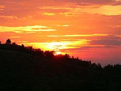
Sunset taken at Kanlaon Volcano's slope | ||
| ||
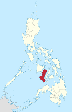
 Map of Negros Oriental with Canlaon highlighted | ||
.svg.png) Canlaon Location within the Philippines | ||
| Coordinates: 10°23′N 123°12′E / 10.383°N 123.200°ECoordinates: 10°23′N 123°12′E / 10.383°N 123.200°E | ||
| Country | Philippines | |
| Region | Negros Island Region (NIR/Region XVIII) | |
| Province | Negros Oriental | |
| Congr. district | 1st district of Negros Oriental | |
| Barangays | 12 | |
| Government[1] | ||
| • Mayor | Jimmy Jayme L. Clerigo | |
| • Vice Mayor | Jose Chubasco Cardenas | |
| Area[2] | ||
| • Total | 170.93 km2 (66.00 sq mi) | |
| Population (2015)[3] | ||
| • Total | 54,509 | |
| • Density | 320/km2 (830/sq mi) | |
| Time zone | PST (UTC+8) | |
| ZIP code | 6223 | |
| Dialing code | 35 | |

Canlaon, officially the City of Canlaon (Cebuano: Dakbayan sa Canlaon; Hiligaynon: Dakbanwa/Syudad sang Canla-on; Filipino: Lungsod ng Canlaon), is a fourth class city in the province of Negros Oriental, Philippines. According to the 2015 census, it has a population of 54,509 people.[3] Canlaon is located 168 kilometres (104 mi) north from the provincial capital Dumaguete. It is bordered on the east by Vallehermoso and on the south by Guihulngan.
Canlaon is home to the highest peak in its own province and its corresponding island region, Kanlaon Volcano, which is 2,465 metres (8,087 ft) above sea level at its highest point.
History
During the Second World War, the Japanese Imperial Army captured Canlaon City in April 1942, right after the Battle of Bataan. The Japanese occupation of the City ended in early 1945 when soldiers from the Eighth United States Army under Lieutenant General Robert Eichelberger including the 40th Infantry Division (United States) and the 23rd Infantry Division (United States), landed in Negros Island to drive out the Japanese. In liberating Negros Island, they were assisted by newly-formed Philippine Commonwealth military forces & local Negrosanon guerillas who helped in clearing out Japanese pockets of resistance throughout the island. In fact, the honor of liberating Canlaon City from the Japanese went to Philippine Commonwealth soldiers belonging to the 7th, 71st, 73rd and 75th Infantry Regiments of the Philippine Army, the 7th Infantry Regiment of the Philippine Constabulary and Negrosanon Guerillas.
The Banyan Tree inside the OISCA Farm is estimated by botanists from Silliman University to be around 1,328 years old. It is home to lizards, bats, and many varieties of insects. It may be considered Canlaon City's main tourist attraction.
Barangays
Canlaon City is politically subdivided into 12 barangays.[2]
- Bayog
- Binalbagan
- Bucalan (East Budlasan)
- Linothangan
- Lumapao
- Malaiba
- Masulog
- Panubigan
- Mabigo (Poblacion – Canlaon Proper)
- Pula
- Budlasan (West Budlasan)
- Aquino
Demographics
| Population census of Canlaon | ||
|---|---|---|
| Year | Pop. | ±% p.a. |
| 1990 | 37,165 | — |
| 1995 | 41,334 | +2.01% |
| 2000 | 46,548 | +2.58% |
| 2007 | 50,208 | +1.05% |
| 2010 | 50,627 | +0.30% |
| 2015 | 54,509 | +1.42% |
| Source: National Statistics Office[3] | ||
The languages widely spoken here in the City of Canlaon: Cebuano and Hiligaynon. Filipino and English are rather used as second languages.
References
- ↑ "Elected Mayors – Vice-Mayors and Councilors in Negros Oriental". Dumaguete.com. Retrieved 2016-05-15.
- 1 2 "Province: Negros Oriental". PSGC Interactive. Makati City, Philippines: National Statistical Coordination Board. Archived from the original on 23 May 2013. Retrieved 11 March 2013.
- 1 2 3 "NEGROS ISLAND REGION (NIR)". Census of Population (2015): Total Population by Province, City, Municipality and Barangay (Report). PSA. Retrieved 20 June 2016.
External links
- Philippine Standard Geographic Code
- Philippine Census Information
- Local Governance Performance Management System
- Photo Duel: Wonder Tree vs Centennial Tree
 |
Bago, Negros Occidental | San Carlos, Negros Occidental | | |
| La Carlota, Negros Occidental La Castellana, Negros Occidental |
|
Vallehermoso | ||
| ||||
| | ||||
| Guihulngan |