Sibulan
| Sibulan | |
|---|---|
| Municipality | |
|
Sibulan Public Plaza | |
 Map of Negros Oriental showing the location of Sibulan | |
.svg.png) Sibulan Location within the Philippines | |
| Coordinates: 09°21′N 123°17′E / 9.350°N 123.283°ECoordinates: 09°21′N 123°17′E / 9.350°N 123.283°E | |
| Country | Philippines |
| Region | Negros Island Region (NIR/Region XVIII) |
| Province | Negros Oriental |
| District | 2nd district of Negros Oriental |
| Barangays | 15 |
| Government[1] | |
| • Mayor | Jose Abiera |
| • Vice Mayor | Marcela Bartoces |
| Area[2] | |
| • Total | 163.00 km2 (62.93 sq mi) |
| Population (2015)[3] | |
| • Total | 59,455 |
| • Density | 360/km2 (940/sq mi) |
| Time zone | PST (UTC+8) |
| ZIP code | 6201 |
| Dialing code | 35 |
| Website |
www |

Sibulan, officially the Municipality of Sibulan (Cebuano: Lungsod sa Sibulan; Filipino: Bayan ng Sibulan) is a second-class municipality in the province of Negros Oriental in Negros Island Region, Philippines. According to the 2015 census, it has a population of 59,455 people.[3]
Sibulan is bordered to the south by the provincial capital of Dumaguete City. It is the location of the Dumaguete Airport, the main airport for Negros Oriental.
Sibulan is also the location of the Balinsasayao Twin Lakes Natural Park, composed of Lake Balinsasayao and Lake Danao. The site, managed by the provincial government, is located 1,047 metres (3,435 ft) above sea level on Mount Talinis.
Barangays
Sibulan is politically subdivided into 15 barangays.[2]
- Agan-an
- Ajong
- Balugo
- Boloc-boloc
- Calabnugan
- Cangmating
- Enrique Villanueva
- Looc
- Magatas
- Maningcao
- Maslog
- Poblacion
- San Antonio
- Tubigon
- Tubtubon
Sibulan has six coastal barangays: from north to south they are Ajong, Looc, Poblacion, Cangmating, Maslog, Agan-an and Boloc-boloc. The provincial airport, known as the Dumaguete Airport, is actually in Agan-an, Sibulan. There is a growing number of guest houses and beach resorts from Cangmating southward to Dumaguete and the coral reefs of Ajong are attracting more dive boats.
The municipal seat is in barangay Poblacion, approximately midway along the coast of the town. The main municipal port facility is in Poblacion, where a fast ferry runs every hour to Santander on the tip of Cebu island. There is also a fishing and freight port in barangay Looc.
Sibulan has two small Marine Protected Areas (MPAs), which are coral reef areas that prohibit fishing, swimming and diving. One is in Agan-an, just north of the airport, the other is in Cangmating. These were established to improve the sustainability of the local fishery.
The inland barangays are primarily agricultural and residential with minimal business and public facilities. Most commercial development is along the national highway, which runs the length of the town from Dumaguete in the south to San Jose at the north. Most business and light industry is along the highway in Boloc-Boloc, Maslog, Agan-an and Poblacion. This is largely urban sprawl from Dumaguete seeking the advantageous tax rates in Sibulan.
Sibulan also boasts a golf course resort, perched on the foothills in barangay San Antonio, just north of the town center.
Demographics
| Population census of Sibulan | ||
|---|---|---|
| Year | Pop. | ±% p.a. |
| 1990 | 27,172 | — |
| 1995 | 31,206 | +2.63% |
| 2000 | 37,523 | +4.03% |
| 2007 | 47,162 | +3.20% |
| 2010 | 51,519 | +3.27% |
| 2015 | 59,455 | +2.77% |
| Source: National Statistics Office | ||
Education
Public High Schools[4]
| Name | Location |
|---|---|
| Ajong National High School | North National Highway, Ajong Negros Oriental |
| Bolocboloc High School | Bolocboloc, Sibulan |
| Enrique Villanueva High School | Tubod, Enrique Villanueva Sibulan |
| Maningcao National High School | Maningcao, Sibulan |
| San Antonio National High School | San Antonio, Negros Oriental |
| Sibulan National High School | Osmena St., Poblacion |
| Sibulan NHS - Balugo Ext. | Balugo, Sibulan Negros Oriental |
| Sibulan National High School - Maslog Ext. | Maslog, Sibulan |
| Sibulan Science High School | Campaclan, Sibulan |
| Tubigon High School | Tubigon, Sibulan |
| Sibulan Night High School | Poblacion, Sibulan |
Elementary Schools[4]
- Bagtic Public School (Tubod)
- Balugo Elementary School
- Bolocboloc Elementary School
- Calabnugan Elementary School
- Calinawan Elementary School
- Cambajao Elementary School
- Cangmating Elementary School
- Cantalawan Elementary School
- Escaguit Elementary School
- Libertad Ong Calderon Memeorial ES (Ajong Elementary School)
- Lo-oc Elementary School
- Magatas Elementary School
- Magsaysay Memeorial Elementary School
- Maningcao Elementary School
- Maslog Elementary School
- San Antonio Elementary School
- Sibulan Central Elementary School
- Tubigon Elementary School
- Tubtubon Elementary School
Gallery
 Municipal hall
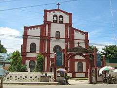 Bell-gabled Church
 Lake Balinsasayao
References
- ↑ "Elected Mayors – Vice-Mayors and Councilors in Negros Oriental". Dumaguete.com. Retrieved 2016-05-16.
- 1 2 "Province: Negros Oriental". PSGC Interactive. Makati City, Philippines: National Statistical Coordination Board. Retrieved 13 March 2013.
- 1 2 "NEGROS ISLAND REGION (NIR)". Census of Population (2015): Total Population by Province, City, Municipality and Barangay (Report). PSA. Retrieved 20 June 2016.
- 1 2 "dumaguete.com". Retrieved Sep 30, 2014.
External links
| Wikimedia Commons has media related to Sibulan, Negros Oriental. |
- The travel guide Wikivoyage includes Sibulan in its Dumaguete article.
- Philippine Standard Geographic Code
- Philippine Census Information
- Local Governance Performance Management System
 |
Pamplona | Tanjay / Amlan / San Jose | Santander, Cebu Tañon Strait |
|
| Santa Catalina | |
Bohol Sea | ||
| ||||
| | ||||
| Valencia / Dumaguete |
Dumaguete (capital) | |
| Municipalities | |
| Component cities | |