Silay
| Silay | ||
|---|---|---|
| Component City | ||
| Lungsod ng Silay (Tagalog) | ||
|
| ||
| ||
| Nickname(s): "The Paris of Negros", "The Visayan Marseille" | ||
| Anthem: Silaynon Song | ||
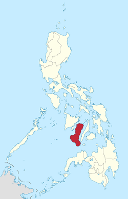
 Map of Negros Occidental with Silay highlighted | ||
.svg.png) Silay Location within the Philippines | ||
| Coordinates: 10°48′N 122°58′E / 10.800°N 122.967°ECoordinates: 10°48′N 122°58′E / 10.800°N 122.967°E | ||
| Country | Philippines | |
| Region | Negros Island Region (NIR/Region XVIII) | |
| Province | Negros Occidental | |
| District | 3rd district of Negros Occidental | |
| Founded | 1565 | |
| Cityhood | June 12, 1957 | |
| Barangays | 16 (11 Barangays in Urban Divisions and 5 Barangays in Rural Division) | |
| Government[1] | ||
| • Mayor | Mark J. Golez | |
| Area[2] | ||
| • Total | 214.80 km2 (82.93 sq mi) | |
| Population (2015 census)[3] | ||
| • Total | 126,930 | |
| • Density | 590/km2 (1,500/sq mi) | |
| Demonym(s) | Silaynon | |
| Time zone | PHT (UTC+8) | |
| ZIP code | 6116 | |
| Dialing code | 34 | |
| Income class | 3rd class city; partially urban[4] | |
| Website |
www | |


Silay, officially City of Silay, is a third class city in the province of Negros Occidental, Philippines. According to the 2010 census, it had a total population of 120,999 people.[5] It is part of the metropolitan area called Metro Bacolod, which includes the cities of Bacolod and Talisay.[6] It has a sizable commercial and fishing port and is the site of the new Bacolod-Silay International Airport, which replaced the Bacolod City Domestic Airport.
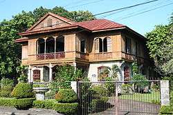
Silay is often referred to as the "Paris of Negros"[7] due to its artists, cultural shows and large collection of perfectly preserved heritage houses. More than thirty of these houses have been declared by the National Historical Commission of the Philippines as part of the Silay National Historical Landmark.[8][9] In 2015, the city celebrated its 58th charter anniversary.[10]
Etymology
The appellation Silay is derived from the name of a tree which grew abundantly in the area. The kansilay is the city's official tree.
The legend of Princess Kansilay
A local legend tells of how Silay City got its name. It is said that in the days of the datus and rajahs, there once lived a princess named Kansilay. An attack on the settlement by pirates was thwarted when the princess bravely led the people in the village's defense. The fight was furious and the princess fought like a seasoned warrior. Murals that used to grace some of the city's public buildings depict her as a fierce fighter wielding a huge talibong, a short native single-edged sword. The pirates were routed, but at the cost of the princess' life. Her paramour arrived in time to see her die. In grief, the people lovingly buried her. To their surprise, a tree grew right over her grave, the first Kansilay tree, a final gift from the brave princess.
History
Spanish colonization
Silay was first settled in 1565 under the name "Carobcob", which means "to scratch" in Kinaray-a; residents of the settlement relied upon harvesting tuway clams, which involved "scratching" (or raking) the sands for the mollusks at low tide, as a means of livelihood. In early writings, the settlement was also referred to as "Calubcub", "Caracol" and "Caraco".[11] The last two variations mean "snail" or a "spiral" in Spanish. Carobcob was built near the mouth of a creek; nothing is left of the village today. Carobcob was granted as an encomienda to Cristobal Nuñez Paroja, one of the seventeen soldiers of Miguel López de Legazpi on January 25, 1571.
In the second half of the century, Moro slave raiders escalated their incursions on the island, forcing the Corregidor of Negros to adopt the policy of flight rather than resistance. People left their homes sometime in 1760 and settled in a new location between two small rivers, Matagoy and Panaogao. A paloisades or estacada (Spanish for "fortification") was constructed to protect the populace from Moro raiders. The place is now known as Sitio Estaca, its name derived from the Spanish word estacada.
In 1760 Silay was recognized as a town being referred to in a letter from Governor Juan Jose de Mijares (1772–1775) mentioning Silay as a leading town in the north. In 1776, the bishop of Cebu considered Silay as the center of the parish. In 1760, it became a pueblo or town. By 1896, it had become a leading sugar-producing area because of the Horno Economico (sugar mill) built in 1846 by a Frenchman who became a permanent resident of Silay, Yves Leopold Germain Gaston.
Negros Revolution
With the outbreak of the Revolution of 1896 came a division between the sugarcane planters of Silay and the clergy. Some planters and clergy supported the rebels while others were against the revolution. On November 5, 1898 at about 2:00 in the afternoon, residents of Silay gathered in the street corner now known as Cinco de Noviembre Street and from there they proceeded to the Spanish garrison near the Catholic Church. The encounter was bloodless. The Spanish civil guard commander, Lt. Maximiano Correa, refused to surrender. After negotiations with the revolutionaries mediated by Juan Viaplana, a local Spaniard, the Spanish garrison did surrender. A Philippine flag was raised for the first time at the Silay plaza later that afternoon. Leandro Locsin became temporary president after the signing of the terms of surrender. Timoteo Unson and the group of Silay residents then marched south to join forces with some residents of Talisay for an attack on Bacolod.
World War II
On the slopes of Mt. Silay lies Patag, the site of the Japanese military's last stand in Western Visayas during World War II. In 1945, U.S. military forces landed in Negros Island. The occupying forces of the Nagano Detachment of the Imperial Japanese Army retreated to Silay and proceeded up Mt. Silay to Patag. There, they established a defensive position. Military forces of the Philippine Commonwealth and soldiers of the U.S. 40th Infantry Division proceeded up the slopes of Mt. Silay with help from Filipino soldiers of the 7th, 71st, 72nd and 75th Infantry Division of the Philippine Commonwealth Army and Negrosanon guerrilla fighters and defeated the Japanese defenders. Today, the site is marked by a monument dedicated to the efforts which led to the liberation of Negros Island.
Cultural and political aspects

Silay City had been known in the past as the "Paris of Negros" and the "cultural and intellectual hub of Negros" due to the residents' love for knowledge and works of art, and its collection of heritage mansions built during the height of the Philippine sugar industry's success, of which Negros was the center. Most notable among these houses is Balay Negrense, the mansion of the son of the first Negrense sugar baron, Yves Leopold Germain Gaston and the Hofileña Ancestral House built by Manuel Severino Hofileña for his wife, former Miss Silay Gilda Ledesma Hojilla.
Silay became a chartered city on June 12, 1957 by virtue of Republic Act 1621.
On June 7, 2003, Silay City became the first local government unit in the Republic of the Philippines to hold a referendum through a People's Initiative approving the 2003 annual executive budget.
Today, Silay City is listed by the Department of Tourism as one of its 25 tourist destinations in the Philippines. It is considered the seat of arts, culture and ecotourism in Western Visayas (before Negros Island Region was created).
Barangays
Silay City is politically sub-divided into 16 barangays.[2]
- Barangay I (Poblacion) (Urban Division)
- Barangay II (Pob.) (Urban Division)
- Barangay III (Pob.) (Urban Division)
- Barangay IV (Pob.) (Urban Division)
- Barangay V (Pob.) (Urban Division)
- Barangay VI (Pob.) (Hawaiian) (Rural Division)
- Eustaquio Lopez (Rural Division)
- Guimbala-on (Rural Division)
- Guinhalaran (Urban Division)
- Kapitan Ramon (Rural Division)
- Lantad (Rural Division)
- Mambulac (Urban Division)
- Rizal (Urban Division)
- Bagtic (Rural Division)
- Patag (Rural Division)
- Balaring (Rural Division)
Demographics
| Population census of Silay | ||
|---|---|---|
| Year | Pop. | ±% p.a. |
| 1990 | 101,031 | — |
| 1995 | 122,748 | +3.72% |
| 2000 | 107,722 | −2.76% |
| 2007 | 120,365 | +1.54% |
| 2010 | 120,999 | +0.19% |
| 2015 | 126,930 | +0.92% |
| Source: National Statistics Office[5][12] | ||
Transportation
Airports
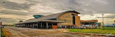
The Bacolod-Silay International Airport, serves the whole Metro Bacolod area and surrounding places. The P4.37-billion airport is capable of handling all-weather and night-landing operations. Its 2,000-meter (6,600 ft.) long and 45-meter (148 ft.) wide primary runway, and 678-meter by 23-meter taxiways can accommodate Airbus A320 family-size aircraft, and the Boeing 737, while the apron can hold five aircraft at any one time. The runway runs in a direction of 03°/21°. Provisions for a 500-meter (1,600 ft) expansion of the present runway in order to accommodate even larger airplanes like the Airbus A330, Airbus A340 and Boeing 747 are now in place. The airport is expected to be the primary entrance by air to Negros Island Region.
Silay is 50 minutes by air from Manila, 30 minutes by air from Cebu, 1 hour by air from Cagayan de Oro and 37.2 minutes by air from General Santos. Commercial airlines operating in the Bacolod-Silay International Airport are Philippine Airlines, Cebu Pacific Air, PAL Express, Zest Airways and South East Asian Airlines.
Schools
Silay City has more importance about education for the honor of the DepEd Silay City. Many public schools and private schools are here at Silay City.
Public Schools
Elementary
- Silay South Elementary School
- Silay North Elementary School
- Governor Emilio Gaston Memorial Elementary School
- Mambulac Elementary School
- Guinhalaran Integrated School
- Balaring Elementary School
- Don Estaquio Hofileña Memorial School
- Villa Miranda Elementary School
- Estaquio Lopez Elementary School
- Patag Elementary School
- Silay SPED Center (Elementary)
- Salvacion Elementary School
- Emiliano Lizares Elementary School
- Hinicayan Elementary School
- Hawaiian-Philippine Company Elementary School
- Sto. Rosario Elementary School
High Schools
- Doña Montserrat Lopez Memorial High School
- Brgy. E Lopez National High School
- Brgy. Guimbalaon National High School
- Don Felix T. Lacson National High School
- Doña Montserrat Lopez Memorial High School HPCO Extension
- Doña Montserrat Lopez Memorial High School Patag Extension
- Doña Montserrat Lopez Memorial High School Sto. Rosario Extension
- Don Albino and Doña Dolores Jiaon Integrated School
- Lantawan Integrated School
- Don Serafin L. Golez Memorial Integrated School
- Napilas Integrated School
- Sibato Integrated School
- Violeta Integrated School
- Silay SPED Center
- Guinhalaran Integrated School
Sister city
Silay City has been twinned with the following cities:
Local
International
Notable residents
See also
References
- ↑ "Municipalities". Quezon City, Philippines: Department of the Interior and Local Government. Retrieved 8 March 2013.
- 1 2 "Province: Negros Occidental". PSGC Interactive. Makati City, Philippines: National Statistical Coordination Board. Retrieved 8 March 2013.
- ↑ "NEGROS ISLAND REGION (NIR)". Census of Population (2015): Total Population by Province, City, Municipality and Barangay (Report). PSA. Retrieved 20 June 2016.
- ↑ http://www.nscb.gov.ph/activestats/psgc/municipality.asp?muncode=064526000®code=06&provcode=45
- 1 2 "Total Population by Province, City, Municipality and Barangay: as of May 1, 2010" (PDF). 2010 Census of Population and Housing. National Statistics Office. Retrieved 8 March 2013.
- ↑ "Building Globally Competitive Metro Areas in the Philippines" (PDF). Archived (PDF) from the original on 5 July 2010. Retrieved 2010-06-16.
- ↑ "Silay City - Negros Occidental Provincial Government". Retrieved 2012-01-03.
- ↑ National Historical Commission of the Philippines (July 1990). "Declaring a Portion of Silay City, Negros Occidental, A National Historical Landmark" (PDF). Retrieved 22 June 2015.
- ↑ National Historical Commission of the Philippines (30 October 1990). "Amending Resolution No. 2, s. 1990, Dated July 1990, Declaring a Portion of Silay City, Negros Occidental, A National Historical Landmark" (PDF). Retrieved 22 June 2015.
- ↑ Pacete, Severino (9 June 2015). "Silaynons who made Silay". Sun.Star. Retrieved 22 June 2015.
- ↑ Sa-onoy, Modesto (2006). Parroquia de San Diego. Today Printers and Publishers. p. 1.
- ↑ "Province of Negros Occidental". Municipality Population Data. LWUA Research Division. Retrieved 16 August 2013.
- ↑ "Silay City celebrates Tourism Month". Philippine Information Services. 2008-09-02. Retrieved 2008-09-04.
External links
| Wikimedia Commons has media related to Silay City. |
- Official Website of the City of Silay
- 2007 Philippine Census Information Region VI - Western Visayas
- Local Governance Performance Management System
 |
Enrique B. Magalona / Victorias | Cadiz | | |
| Guimaras Strait | |
Calatrava | ||
| ||||
| | ||||
| Talisay |