Negros (Philippines)
| Negros | ||||||||
|---|---|---|---|---|---|---|---|---|
| Region | ||||||||
| Negros Island Region NIR / Region XVIII | ||||||||
From upper-left to lower-right: MassKara Festival, The Ruins, Balay Negrense, Mabinay Crystal Cave, Balinsasayao Twin Lakes Natural Park, Silliman University | ||||||||
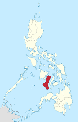 Location in the Philippines | ||||||||
| Coordinates: PH 10°N 123°E / 10°N 123°ECoordinates: PH 10°N 123°E / 10°N 123°E | ||||||||
| Country | Philippines | |||||||
| Island Group | Visayas | |||||||
| Regional Center | Bacolod and Dumaguete¹ | |||||||
| Area | ||||||||
| • Total | 13,350.74 km2 (5,154.75 sq mi) | |||||||
| Population (2015)[1] | ||||||||
| • Total | 4,414,131 | |||||||
| • Density | 330.63/km2 (856.3/sq mi) | |||||||
| Demonym(s) |
| |||||||
| Divisions | ||||||||
| • Provinces | ||||||||
| • Highly urbanized city |
1
| |||||||
| • Component cities | ||||||||
| • Municipalities | 38 | |||||||
| • Barangays | 1,219 | |||||||
| • Districts | 11 | |||||||
| Time zone | PST (UTC+8) | |||||||
| Spoken languages | ||||||||
| ||||||||
.jpg)


Negros is an island in the Philippines, which is the fourth largest in the country with a total land area of 13,309.60 square kilometres (5,138.87 sq mi).[2] Negros is one of the islands that comprise the Visayas, which forms the central division of the country.
As an administrative region, it is officially named the Negros Island Region (Hiligaynon: Rehiyon sang Pulo sang Negros; Cebuano: Rehiyon sa Pulo sa Negros; Filipino: Rehiyon ng Pulo ng Negros) also abbreviated as NIR, the 18th and newest region of the Philippines, comprising the highly urbanized city of Bacolod and the provinces of Negros Occidental and Negros Oriental, along with its corresponding outlying islands and islets.[3][4]
It was created by virtue of Executive Order No. 183 issued by President Benigno Aquino III on May 29, 2015.[5][6] Inhabitants of the island region are mainly called Negrenses (locally Negrosanons). As of 2015, Negros Island Region's total population is 4,414,131.[1]
History
Precolonial era
Negros was originally called Buglas, an old Hiligaynon word thought to mean "cut off", as it is believed that the island was separated from a larger landmass by rising waters during the last ice age. Among its earliest inhabitants were the dark-skinned Ati people, one of several aboriginal Negrito ethnic groups dispersed throughout Asia that possesses a unique culture. The westernmost portions of the island soon fell under the rule of the Kedatuan of Madja-as from the neighbouring island of Panay.
Spanish colonization
Upon arriving on the island in April 1565, the Spanish colonisers called the land Negros after the black natives they observed. Two of the earliest native settlements, Binalbagan and Ilog, became towns in 1573 and 1584, respectively, while other settlements of the period included Hinigaran, Bago, Marayo (now Pontevedra), Mamalan (now Himamaylan), and Candaguit (a sitio of San Enrique). In 1572, King Philip II of Spain conferred the title of Marques de Buglas to the heirs of Juan Sebastián Elcano, the first to circumnavigate the world; the current Marquis is the 17th in line, and resides in Silay City, Negros Occidental.
After appointing encomenderos for the island, Miguel López de Legazpi placed Negros under the jurisdiction of the governor of Oton on Panay. In 1734, however, the island became a military district with Ilog as its first capital. The seat of government was later transferred to Himamaylan until Bacolod became the capital in 1849. In 1865, Negros and its outlying islands along with Siquijor was converted into a politico-military province.
In 1890, the island was partitioned into the present-day provinces of Negros Occidental and Negros Oriental. The Spanish Governor, D. Isidro Castro y Cinceros, surrendered to the Philippine Revolutionists, led by Aniceto Lacson and Juan Araneta, on 6 Nov. 1898.[7]:520 General Miller appointed Aniceto, Governor of the Island in March 1899.[7]:520 On 9 April 1901, the Second Philippine Commission under the chairmanship of William H. Taft arrived in Dumaguete. Weeks later on 1 May, the civil government under American sovereignty was established, and on 28 August, Dr. David S. Hibbard founded what is now Silliman University, with the help of the first Mayor of Dumaguete, Meliton Larena, and The Hon. Demetrio Larena.
Negros Revolution and formation of Republic of Negros
From 3 to 6 November 1898, the Negrense people rose in revolt against the local Spanish colonial government headed by politico-military governor Colonel Isidro de Castro. The Spaniards decided to surrender upon seeing armed troops marching in a pincer movement towards Bacolod. The revolutionaries, led by General Juan Araneta from Bago and General Aniceto Lacson from Talisay, bore fake arms consisting of rifles carved out of palm fronds and cannons of rolled bamboo mats painted black. By the afternoon of 6 November, Col. de Castro signed the Act of Capitulation, thus ending centuries of Spanish rule in Negros Occidental.
In memory of this event, every 5 November is observed as a special non-working holiday in the province through Republic Act № 6709, signed by President Corazon Aquino on 10 February 1989.
On 27 November 1898, the Cantonal Republic of Negros unilaterally proclaimed independence, but this was short-lived as the territory became a protectorate of the United States on 30 April 1899. The state was renamed the Republic of Negros (Spanish: República de Negros) on 22 July 1899, and eventually dissolved by the United States and annexed by the U.S. Military Government of the Philippine Islands on 30 April 1901.
The leaders of the short-lived republic were:[8]
- Aniceto Lacson, November 5, 1898 – July 22, 1899 (to November 27, 1898, in Negros Occidental)
- Demetrio Larena, November 24, 1898 – November 27, 1898 (in Negros Oriental)
- President of the Constituent Assembly José Luzuriaga, July 22, 1899 – November 6, 1899
- Secretary of War Juan Araneta
- Civil Governor Melecio Severino, November 6, 1899 – April 30, 1901
- Secretary of Justice Antonio Ledesma Jayme, July 24, 1854 – October 9, 1937
Formation of regions
Regions first came to existence on September 24, 1972 when the provinces of the Philippines were organized into 11 regions by Presidential Decree No. 1 as part of the Integrated Reorganization Plan of President Ferdinand Marcos. Negros Occidental was assigned to Western Visayas (Region VI) while Negros Oriental became part of Central Visayas (Region VII).
Early initiatives
The movement for a single-island region started in the 1980s when officials of both provinces proposed a one-island, one-region unit. At the time, Negros Occidental and Negros Oriental were the only provinces in the Philippines situated in the same island but belonging to two different administrative regions with regional offices located in neighboring Panay and Cebu. This led to the filing of House Bill No. 1477 titled "An Act Merging the Province of Negros Occidental and Oriental into One-Island Region." They argued, among others, that the two provinces "nestle in one common island; have common fowls and beasts in the forest; share the same soil in our plains and mountains; benefit and suffer together from the rivers that snake through our land; and our ancestors roamed the same length and breadth without complications of political, social, economic, religious and lingual obstacles."
The proposal was continued through talks between former Governor Bitay Lacson of Negros Occidental and the late former Governor Emilio Macias of Negros Oriental in 1990. Their successors, former Governor Rafael Coscolluella and former Governor (now Representative) George Arnaiz took the initiative further, first identifying Kabankalan City in Negros Occidental and the neighboring municipality of Mabinay in Negros Oriental, with the two situated on or near the geographic center of the island, as joint regional centers. However, the National Economic and Development Authority (NEDA) turned down the proposal for lack of funds to effect the merger.[9]
Revival of proposal

In 2013, the one-island region talks were continued by Negros Oriental Representatives Pryde Henry Teves and George Arnaiz and Negros Occidental Governor Alfredo Marañon Jr. with Representative Alfredo Marañon III and Coscolluela.[10] They pointed out that while the creation of a new region will entail substantial costs to the government, it will be advantageous to the people of both provinces because they would not need to travel by sea anymore to process transactions in the regional offices.[11] They also claimed that a one-island region would also result to better coordination between both provinces in tourism, peace and order, environment, development planning, disaster management and road infrastructure. Edward Du, president of the Negros Oriental Chamber of Commerce and Industry, also proposed to convert existing offices of national agencies in the provincial capitals of Bacolod and Dumaguete to sub-regional offices during an interim period if the proposal is approved to defray the costs of establishing a new regional center. Various public officials and representatives from the academe, religious, media and other private sectors aired support for the proposal.[12][13]
Notably, Negros Oriental Governor Roel Degamo was tagged to be initially opposed to the talks, claiming he was not convinced with a one-island region setup and that his constituents are allegedly not in favor of its creation.[14] He eventually clarified that his original stand as regards the region was being "open" to it and that there were some concerns, such as revenue sharing between the two provinces, that had to be threshed out first.[15]
President Benigno Aquino III directed the Department of the Interior and Local Government (DILG) to study the establishment of a new region.[16] The DILG subsequently endorsed the proposal, noting that the new region would mean integrated planning for holistic development, disaster management, tourism promotion, and peace and order management.[17] NEDA affirmed by saying that its studies show that the proposed region is economically viable.[18]
Establishment
On May 29, 2015, President Aquino signed Executive Order 183,[19] joining the twin Negros provinces into one region—the Negros Island Region. It separated Negros Occidental from Region VI and Negros Oriental from Region VII, making the total number of regions of the Philippines to 18.[5][6]
Future development
The possible inclusion of Siquijor to this newly formed island region was thought by the Interior Secretary Mar Roxas during his visit in the province. Currently, Siquijor is part of Central Visayas. On average, it takes five hours to reach the regional offices located in Cebu while an hour to get to Negros Oriental. Siquijor used to be a part and later on a sub-province of Negros Oriental, gaining full province status in 1973.[20]
Due to the rise of the Philippine government's conversion into federalism under President Rodrigo Duterte, Negros Island Region may have the capability to become a separate federal state.[21] If Negros island Region is elevated into a federal state, then it will be able to reform and re-develop itself in order to make the region self-reliant and highly sustainable in the future, as well as probably gain an HDI higher than the rest of the nation.
Demographics
| Population census of Negros Island Region | ||
|---|---|---|
| Year | Pop. | ±% p.a. |
| 2000 | 3,695,811 | — |
| 2010 | 4,194,525 | +1.27% |
| 2015 | 4,414,131 | +0.98% |
| Source: Philippine Statistics Authority[1] | ||
Geography
 Mount Kanlaon, the highest peak in the island | |
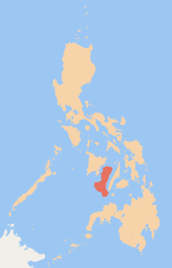 Map of the Philippines showing Negros in red | |
| Geography | |
|---|---|
| Location | South East Asia |
| Archipelago | Visayas |
| Adjacent bodies of water | |
| Area | 13,309.6 km2 (5,138.9 sq mi)[2] |
| Area rank | 62nd |
| Coastline | 644.9 km (400.72 mi)[22] |
| Highest elevation | 2,465 m (8,087 ft)[23] |
| Highest point | Kanlaon Volcano |
| Administration | |
| Region | Negros Island Region |
| Provinces | |
| Largest settlement | Bacolod City (pop. 561,875) |
| Demographics | |
| Demonym | Negrense/Negrosanons |
| Population | 4,414,131 (2015)[1] |
| Pop. density | 331.7 /km2 (859.1 /sq mi) |
| Ethnic groups | Visayans (Hiligaynons & Cebuanos) |
Negros Island is the fourth largest island of the Philippines and the second largest in the Visayas, with a total land area of 13,309.6 square kilometres (5,138.9 sq mi).[2] It is located between the islands of Panay and Guimaras to the west and Cebu to the east, with Siquijor located on the toe of the island and the islands of Bantayan to the north. Politically and linguistically, Negros is divided into two provinces: Negros Occidental and Negros Oriental, together comprising the Negros Island Region.
This division of the island, which roughly follows the mountain range in the center of the island, corresponds to the two ethnolinguistic groups. The western section (Occidental) is home to the Ilonggo-speaking population while the eastern section (Oriental) is home to the Cebuano-speaking population. Together, they are all called as Negrenses.
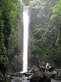
Kanlaon Volcano in the central-northern part of the island is the third most active volcano in the Philippines and overlooks bordering communities and the city of Bacolod. It is the highest peak on the island and of the whole Visayas. Other notable peaks on the island are Mount Silay and Mount Mandalagan in Negros Occidental and Mount Talinis (also known as Cuernos de Negros) in Negros Oriental. There are also lakes that dot the island, among the most notable are the Balinsasayao Twin Lakes in Negros Oriental.
The volcanic activity in Negros is harvested into electricity through two geothermal power plants in the island. One is located in Palinpinon, Valencia, Negros Oriental, and the other is in Mailum of Bago City, Negros Occidental but was eventually shut down.
Administrative divisions
Negros Island Region comprises 2 provinces, 1 highly urbanized city, 18 component cities, 38 municipalities and 1,219 barangays.
| Province or HUC | Capital | Population (2015)[1] | Area[24] | Density | Cities | Muni. | Bgy. | ||||||
|---|---|---|---|---|---|---|---|---|---|---|---|---|---|
| km2 | sq mi | /km2 | /sq mi | ||||||||||
| Negros Occidental | Bacolod | 56.6% | 2,497,261 | 7,802.54 | 3,012.58 | 320 | 830 | 12 | 19 | 601 | |||
| Negros Oriental | Dumaguete | 30.7% | 1,354,995 | 5,385.53 | 2,079.36 | 250 | 650 | 6 | 19 | 557 | |||
| Bacolod | † | — | 12.7% | 561,875 | 162.67 | 62.81 | 3,500 | 9,100 | — | — | 61 | ||
| Total | 4,414,131 | 13,350.74 | 5,154.75 | 330 | 850 | 19 | 38 | 1,219 | |||||
|
† Bacolod is a highly-urbanized city; figures are excluded from Negros Occidental. | |||||||||||||
Negros Island Region has the least number of provinces in the Philippines (only 2). It has 19 cities (including the highly urbanized city of Bacolod) in total, making it the region with the most cities, tying alongside with CALABARZON, which also has 19 cities.
Negros Occidental has the most chartered cities amongst all the provinces in the Philippines. The province comprises 13 cities and 19 municipalities, which are further subdivided into 601 barangays. Although Bacolod serves as the capital, it is governed independently from its corresponding province as a highly urbanized city. Negros Oriental comprises 6 cities and 19 municipalities, with 557 barangays.
| City | Population (2015)[1] | Area[25] | Density | City class | Income class | Province | ||
|---|---|---|---|---|---|---|---|---|
| km2 | sq mi | /km2 | /sq mi | |||||
| Bacolod | 561,875 | 162.67 | 62.81 | 3,500 | 9,100 | Highly urbanized | 1st | Negros Occidental |
| Bago | 170,981 | 401.20 | 154.90 | 430 | 1,100 | Component | 2nd | Negros Occidental |
| Bais | 76,291 | 319.64 | 123.41 | 240 | 620 | Component | 3rd | Negros Oriental |
| Bayawan | 117,900 | 699.08 | 269.92 | 170 | 440 | Component | 2nd | Negros Oriental |
| Cadiz | 154,723 | 524.57 | 202.54 | 290 | 750 | Component | 2nd | Negros Occidental |
| Canlaon | 54,509 | 170.93 | 66.00 | 320 | 830 | Component | 4th | Negros Oriental |
| Dumaguete | 131,377 | 33.62 | 12.98 | 3,900 | 10,000 | Component | 3rd | Negros Oriental |
| Escalante | 94,070 | 192.76 | 74.43 | 490 | 1,300 | Component | 4th | Negros Occidental |
| Guihulngan | 95,969 | 388.56 | 150.02 | 250 | 650 | Component | 5th | Negros Oriental |
| Himamaylan | 106,880 | 367.04 | 141.71 | 290 | 750 | Component | 3rd | Negros Occidental |
| Kabankalan | 181,977 | 697.35 | 269.25 | 260 | 670 | Component | 1st | Negros Occidental |
| La Carlota | 64,469 | 137.29 | 53.01 | 470 | 1,200 | Component | 4th | Negros Occidental |
| Sagay | 146,264 | 330.34 | 127.54 | 440 | 1,100 | Component | 3rd | Negros Occidental |
| San Carlos | 132,536 | 451.50 | 174.33 | 290 | 750 | Component | 2nd | Negros Occidental |
| Silay | 126,930 | 214.80 | 82.93 | 590 | 1,500 | Component | 3rd | Negros Occidental |
| Sipalay | 70,070 | 379.78 | 146.63 | 180 | 470 | Component | 4th | Negros Occidental |
| Talisay | 102,214 | 201.18 | 77.68 | 510 | 1,300 | Component | 4th | Negros Occidental |
| Tanjay | 80,532 | 276.05 | 106.58 | 290 | 750 | Component | 4th | Negros Oriental |
| Victorias | 87,933 | 133.92 | 51.71 | 660 | 1,700 | Component | 4th | Negros Occidental |
Transportation
Airports
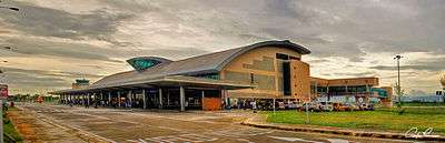
International
Domestic
- Dumaguete Airport
- Kabankalan Airport (under construction)
Economy
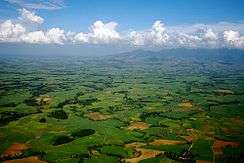
Negros is noted for being the country's prime producer of sugar. Sugarcane plantations abound in the agricultural areas of the island. The island also produces cotton and hardwood. Sugar is the biggest industry in the island, followed by other agricultural products and gamefowl breeding.[26] Its principal sugar-growing region is located in the north and west of the island, stretching from northwest along the coasts of the Visayan Sea and Guimaras Strait, which is one of the country's principal lowland areas.
Sugar refining has many by-products such as acetylene, fertilizers and rum. Fishing is the major industry based in Cadiz City. There are also a number of fishponds and prawn farming has become a major industry. Bacolod City is the center of commerce and finance in Negros Island Region. It is where oil companies, factories, bottling plants, allied industrial businesses, steel fabrication, power generation, agri-businesses, prawn culture and other aqua-culture ventures are found.[27] By November 2016, Negros Island Region generated a total net worth of ₱36.65 billion,[28] making it the 2nd-richest region of the Visayas (after Central Visayas) and the 5th-richest of the whole Philippines.
Tourism
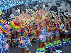
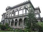
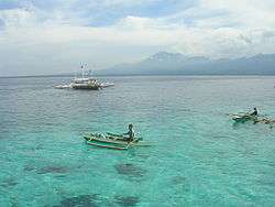
With vast coastlines and huge expanses of land of numerous beautiful sceneries, a colourful culture and a significant history, Negros has boasted numerous tourist attractions, which also helped boost the economy. In Silay City, there are 30 ancestral houses, amongst the most notable is the Balay Negrense. Bais City has since then become a tourist spot for whale and dolphin watching, due to its proximity across the Tañon Strait. Festivals are also a major tourist attraction in Negros, among the most notable, is the Masskara Festival in Bacolod City, which is celebrated during the third week of October.
Energy

The island is known for using geothermal energy to provide electricity for its inhabitants. In San Carlos City, where energy company San Carlos Solar Energy is located, solar energy is being used to power the city and surrounding municipalities.[29] Inland towns and cities of Negros Island Region uses hydroelectric power acquired from springs, rivers and waterfalls. Due to the island region's sugarcane-based agriculture, Negros may become the nation's major biofuel producer, with sugarcane being used for ethanol extracting.[30]
Endangered species
Negros Island Region, like the Central Philippines (Visayas) overall, is generally recognized as a top priority area for wildlife conservation, both in terms of numbers of endemic species and severity of threat. More than half of the critically endangered species listed in the Philippines occurs in Negros and the West Visayas. It is the most threatened area of the Philippines, since it has the least remaining forest cover and the highest numbers of severely threatened endemic species and subspecies. Mt. Silay and Mt. Mandalagan are the two mountain peaks in the Northern Negros Natural Park. These mountains have old-growth forests. Threatened species recorded in this area include the: White-winged cuckooshrike, Visayan Flowerpecker, Flame-templed babbler, Writhed-billed hornbill, Visayan tarictic hornbill, Rufous-lored kingfisher, Blue-naped parrot, Philippine hawk-eagle.[31]
References
- 1 2 3 4 5 6 Census of Population (2015): Highlights of the Philippine Population 2015 Census of Population (Report). PSA. Retrieved 20 June 2016.
- 1 2 3 "2010 Philippine Yearbook" (PDF) (23rd ed.). Manila, Philippines: National Statistics Office. ISSN 0116-1520. Retrieved 2015-12-14.
- ↑ Bueza, Michael (June 5, 2015). "FAST FACTS: The Negros Island Region". Rappler. Retrieved June 21, 2015.
- ↑ Bustillo, Roy (June 20, 2015). "Negros Island Region is now Region XVIII". CNN Philippines. Retrieved June 21, 2015.
- 1 2 "Aquino OKs creation of Negros Island Region". Philippine Daily Inquirer. June 5, 2015. Retrieved June 5, 2015.
- 1 2 "PNoy joins 2 Negros provinces into one region". ABS-CBNnews.com. June 5, 2015. Retrieved June 21, 2015.
- 1 2 Foreman, J., 1906, The Philippine Islands, A Political, Geographical, Ethnographical, Social and Commercial History of the Philippine Archipelago, New York: Charles Scribner's Sons
- ↑ World Statesmen - Philippines - Republic of Negros
- ↑ "What Went Before: A history of splits and mergers". Philippine Daily Inquirer. May 19, 2015. Retrieved June 21, 2015.
- ↑ "One-island region for Negros provinces revived". Philippine Daily Inquirer. June 27, 2013. Retrieved June 21, 2015.
- ↑ Espina, Marchel P. (April 1, 2014). "Talks on one-island Negros region proposal to resume". The Freeman. The Philippine Star. Retrieved June 21, 2015.
- ↑ Gomez, Carla (June 25, 2014). "Island region possible before 2016, Mar says but support data needed". Visayan Daily Star. Retrieved June 21, 2015.
- ↑ Bayoran, Gilbert (May 22, 2014). "More support one-island region". Visayan Daily Star. Retrieved June 21, 2015.
- ↑ Ellera, Teresa (August 7, 2014). "One regional guv for Negros 'not true'". Sun.Star. Retrieved June 21, 2015.
- ↑ Partlow, Judy Flores (May 1, 2015). "On Negros island region: Degamo denies saying "yes"". The Freeman. The Philippine Star. Retrieved June 21, 2015.
- ↑ "One Negros dream: Aquino won't commit, points to Roxas". Philippine Daily Inquirer. May 27, 2014. Retrieved June 21, 2015.
- ↑ Gomez, Carla (January 6, 2015). "PNoy okay of island region seen". Visayan Daily Star. Retrieved June 21, 2015.
- ↑ "NEDA: Negros Occ can survive if separated from WV". The Freeman. The Philippine Star. April 19, 2015. Retrieved June 21, 2015.
- ↑ "Executive Order No. 183, s. 2015". Official Gazette. Retrieved 12 October 2015.
- ↑ Espina, Marchel P. (June 13, 2015). "Top Negrense officials split on Siquijor joining Negros Island Region". Rappler. Retrieved June 20, 2015.
- ↑ Carla N. Canet (July 1, 2016). "Negros Island Region can be a federal state — Pimentel". Manila Bulletin. Retrieved June 20, 2015.
- ↑ "Islands of Philippines". Island Directory. United Nations Environment Programme. Retrieved 18 September 2015.
- ↑ "Kanlaon Volcano". www.phivolcs.dost.gov.ph. Philippine Institute of Volcanology and Seismology. Retrieved 18 September 2015.
- ↑ "PSGC Interactive; List of Provinces". Philippine Statistics Authority. Retrieved 29 March 2016.
- ↑ "PSGC Interactive; List of Cities". Philippine Statistics Authority. Retrieved 29 March 2016.
- ↑ "Bird Flu Alert In Negros". Sun.Star. Retrieved 2014-01-25.
- ↑ "About Negros Occidental - Negros Occidental Provincial Government". www.negros-occ.gov.ph. Retrieved 2016-02-14.
- ↑ "2 Negros provinces among richest in Philippines". Sun.Star. Retrieved 2016-11-05.
- ↑ Official Website of SaCaSol
- ↑ Espina, Rolly (2 May 2006). "Negros may become biofuel center source". The Philippine Star. Retrieved 10 September 2016.
- ↑ Developing Field Research Priorities in Negros Island (West Visayas, Philippines) with particular reference to key threatened endemic species, September 2008, by Bristol Clifton and West of England Zoological Society Fauna and Flora International – Philippines Biodiversity Conservation Programme Philippines Biodiversity Conservation Foundation, Inc.
External links
| Wikivoyage has a travel guide for Negros. |
| Wikimedia Commons has media related to Negros Island. |
- Official Website of the Provincial Government of Negros Occidental
- Official Website of the Provincial Government of Negros Oriental

