Carcar
| Carcar | |
|---|---|
| Component City | |
| City of Carcar | |
|
Carcar from the bell tower of St. Catherine of Alexandria church | |
| Nickname(s): Heritage City of Cebu | |
| Motto: Carcar is NICE | |
 Map of Cebu with Carcar highlighted | |
.svg.png) Carcar Location within the Philippines | |
| Coordinates: 10°06′N 123°38′E / 10.1°N 123.63°ECoordinates: 10°06′N 123°38′E / 10.1°N 123.63°E | |
| Country | Philippines |
| Region | Central Visayas (Region VII) |
| Province | Cebu |
| District | 1st district of Cebu |
| Founded Cityhood |
1599 2007 |
| Barangay | 15 (see § Barangays) |
| Government [1] | |
| • Type | Sangguniang Panlungsod |
| • Mayor | Nicepuro Apura (NP) |
| • Vice mayor | Patrick Barcenas |
| • City Council |
Members
|
| • Representative | Gerald Gullas |
| Area[2] | |
| • Total | 116.78 km2 (45.09 sq mi) |
| includes Bolinawan Islet (26 ha) | |
| Highest elevation | 660 m (2,170 ft) |
| Population (2015 census)[3] | |
| • Total | 119,664 |
| • Density | 1,000/km2 (2,700/sq mi) |
| • Voter (2016)[4] | 63,285 |
| Demonym(s) | Carcaranon |
| Time zone | PHT (UTC+8) |
| Income class | 5th class |
| PSGC | nscb-area |
Carcar, officially the City of Carcar (Cebuano: Dakbayan sa Carcar; Filipino Lungsod ng Carcar), is a 5th city income class component city in the province of Cebu, Philippines. According to the 2015 census, it has a population of 119,664.[3] In the 2016 election, it had 63,285 registered voters.[4]
Carcar lies within Metro Cebu area.[5]
History
Carcar was known as "Sialao" since before the Spanish colonization. It became a municipality in 1599.
Carcar is considered one of the oldest towns in Cebu, with its Spanish influence lasted more than 300 years ago.
-
During the 11th Congress (1998–2001), Congress enacted into law 33 bills converting 33 municipalities into cities. However, Congress did not act on a further 24 bills converting 24 other municipalities into cities.
During the 12th Congress (2001–2004), Congress enacted into law Republic Act No. 9009 (RA 9009), which took effect on 30 June 2001. RA 9009 amended Section 450 of the Local Government Code by increasing the annual income requirement for conversion of a municipality into a city from ₱20 million to ₱100 million. The rationale for the amendment was to restrain, in the words of Senator Aquilino Pimentel, "the mad rush" of municipalities to convert into cities solely to secure a larger share in the Internal Revenue Allotment despite the fact that they are incapable of fiscal independence.
After RA 9009 went into effect, the House of Representatives of the 12th Congress adopted Joint Resolution No. 29, which sought to exempt from the ₱100 million income requirement in RA 9009 the 24 municipalities whose cityhood bills were not approved in the 11th Congress. However, the 12th Congress ended without the Senate having approved Joint Resolution No. 29.
During the 13th Congress (2004–2007), the House of Representatives re-adopted former Joint Resolution No. 29 as Joint Resolution No. 1 and forwarded it to the Senate for approval. However, the Senate again failed to approve the Joint Resolution. Following the suggestion of Senator Aquilino Pimentel (Senate President), 16 municipalities filed, through their respective sponsors, individual cityhood bills. The 16 cityhood bills each contained a common provision exempting it from the ₱100 million income requirement of RA 9009 –
"Exemption from Republic Act No. 9009. — The City of x x x shall be exempted from the income requirement prescribed under Republic Act No. 9009."
On 22 December 2006, the House of Representatives approved the cityhood bills. The Senate also approved the cityhood bills in February 2007, except that of Naga, Cebu which was passed on 7 June 2007. These cityhood bills lapsed into law on various dates from March to July 2007 after President Gloria Macapagal-Arroyo failed to sign them.
The point of law at issue in 2007 was whether there had been a breach of Section 10, Article X of the 1987 Constitution, which provides –
No province, city, municipality, or barangay shall be created, divided, merged, abolished or its boundary substantially altered, except in accordance with the criteria established in the local government code and subject to approval by a majority of the votes cast in a plebiscite in the political units directly affected.
– and in each case the established criteria were far from met.
In November 2008, Carcar and 15 other cities lost their cityhood after the Supreme Court of the Philippines granted a petition filed by the League of Cities of the Philippines, and declared unconstitutional the cityhood law (RA 9436) which had allowed the town to acquire its city status.[6] The Supreme Court ruled that they did not pass the requirements for cityhood.[7][8]
On 10 December 2008, the 16 cities affected acting together filed a motion for reconsideration with the Supreme Court. More than a year later, on 22 December 2009, acting on said appeal, the Court reversed its earlier ruling as it ruled that "at the end of the day, the passage of the amendatory law" (regarding the criteria for cityhood as set by Congress) "is no different from the enactment of a law, i.e., the cityhood laws specifically exempting a particular political subdivision from the criteria earlier mentioned. Congress, in enacting the exempting law/s, effectively decreased the already codified indicators."[9] Accordingly cityhood status was restored.
But on 27 August 2010, the 16 cities lost their city status again, after the Supreme Court voted 7-6, with two justices not taking part, to reinstate the 2008 decision declaring as "unconstitutional" the Republic Acts that converted the 16 municipalities into cities. A previous law required towns aspiring to become cities to earn at least ₱100 million annually, which none of the 16 did.[10]
On 15 February 2011, the Supreme Court made another volte-face and upheld for the third time the cityhood of 16 towns in the Philippines.[11]
Finally, on 12 April 2011, the Supreme Court, in an en banc ruling delivered in Baguio City, affirmed the finality of the constitutionality of the 16 cityhood laws by resolving that:
We should not ever lose sight of the fact that the 16 cities covered by the Cityhood Laws not only had conversion bills pending during the 11th Congress, but have also complied with the requirements of the LGC prescribed prior to its amendment by R.A. No. 9009.[10] Congress undeniably gave these cities all the considerations that justice and fair play demanded. Hence, this Court should do no less by stamping its imprimatur to the clear and unmistakable legislative intent and by duly recognizing the certain collective wisdom of Congress. WHEREFORE, the Ad Cautelam Motion for Reconsideration (of the Decision dated 15 February 2011) is denied with finality.[11]
On 28 June 2011 the Supreme Court directed the Clerk of Court to issue the entry of judgment on the cityhood case of 16 municipalities.[12] This entry of judgment ended the cityhood battle of the 16 cities.
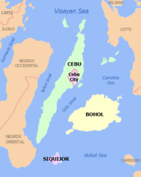
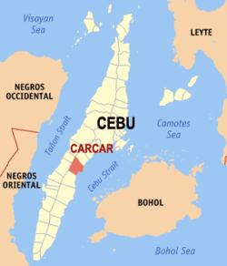
Geography
Carcar is located 40 kilometres (25 mi) south of Cebu City. It is bounded on the north by San Fernando; on the south by Sibonga; on the west by Barili and Aloguinsan; and on the east by the Cebu Strait. It has a land area of 116.78 square kilometres (45.09 sq mi).[2]
- Topography
The land is generally level with less than 18% slope comprising 78.7% of the total land area. Areas with slopes ranging from 18 to 50% cover 19.3% of the total land area and those over 50% slope comprise approximately 1.9%. The highest recorded elevation is a little over 660 metres (2,170 ft) above sea level, located within the barangay of Napo.
- Soil type
The municipality has five dominant soil types namely: Faraon Clay, Steep Phase, the Lugo Clay, the Mandaue clay loam & the Hydrosol type.
- Climate
The wet season occurs during the months of May to October and the dry season, from January to May.
Barangays
Carcar comprises 15 barangays:[2]
| PSGC | Barangay | Population | ±% p.a. | ||
|---|---|---|---|---|---|
| 2015[3] | 2010[13] | ||||
| 072214001 | Bolinawan | 9.1% | 10,881 | 10,852 | +0.05% |
| 072214002 | Buenavista | 2.2% | 2,662 | 2,294 | +2.87% |
| 072214003 | Calidngan | 2.7% | 3,258 | 2,953 | +1.89% |
| 072214004 | Can‑asujan | 7.6% | 9,114 | 7,845 | +2.90% |
| 072214005 | Guadalupe | 10.6% | 12,641 | 10,633 | +3.35% |
| 072214006 | Liburon | 6.4% | 7,606 | 6,749 | +2.30% |
| 072214007 | Napo | 5.4% | 6,427 | 6,344 | +0.25% |
| 072214008 | Ocaña | 7.8% | 9,361 | 8,507 | +1.84% |
| 072214009 | Perrelos | 11.8% | 14,129 | 12,901 | +1.75% |
| 072214012 | Poblacion I | 9.1% | 10,919 | 8,996 | +3.76% |
| 072214013 | Poblacion II | 2.2% | 2,680 | 2,432 | +1.87% |
| 072214014 | Poblacion III | 5.8% | 6,898 | 5,763 | +3.48% |
| 072214015 | Tuyom | 5.1% | 6,080 | 5,563 | +1.71% |
| 072214010 | Valencia | 4.6% | 5,485 | 4,885 | +2.23% |
| 072214011 | Valladolid | 9.6% | 11,523 | 10,606 | +1.59% |
| Total | 119,664 | 107,323 | +2.09% | ||
Demographics
| Population census of Carcar | |||||||||||||||||||||||||
|---|---|---|---|---|---|---|---|---|---|---|---|---|---|---|---|---|---|---|---|---|---|---|---|---|---|
|
| ||||||||||||||||||||||||
| Source: Philippine Statistics Office[3][13][14] | |||||||||||||||||||||||||
In the 2016 election, it had 63,285 registered voters, meaning that 53% of the population are aged 18 and over.[4]
Tourism
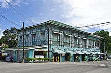
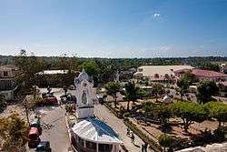
- As a Heritage City of Cebu, Carcar contains various Spanish and American period structures. The Carcar plaza alone hosts several heritage structures, the Church of St. Catherine of Alexandria dominates the area. Within the complex various structures stand, including quaint houses and their distinctive architectural details.
- Surrounding the Rotunda and in the public market one will find the famous Carcar chicharon, lechon, ampao, bucarillo, gogorias and puso – just some of the local delicacies.
- Guadalupe Mabugnao Mainit Hot Spring National Park
- Tuyom Beach – Beach Houses
- Historical Structures – Poblacion II Spanish Antiques
- Calvary Hills Ocaña Station of the Cross
- Miraculous Statue of Perrelos Statue of Virgin Mary
Notable people
- Msgr. Teofilo Bastida Camomot – founded the Congregation of Blessed Virgin Missionaries
- Sheryn Regis – singer
Gallery
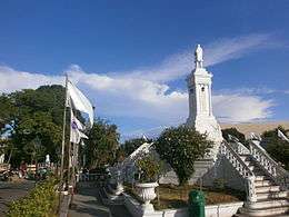 Rizal Monument at Town Plaza
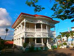 One of the Ancestral Houses located in Carcar
 Carcar Church Interior
 Carcar Town Complex
 Carcar Church Main Altar
References
- ↑ "City". Quezon City, Philippines: Department of the Interior and Local Government. Retrieved 30 May 2013.
- 1 2 3 "Municipal: Carcar". PSGC Interactive. Quezon City, Philippines: Philippine Statistics Authority. Retrieved 8 January 2016.
- 1 2 3 4 "Region VII (CENTRAL VISAYAS)". Census of Population (2015): Total Population by Province, City, Municipality and Barangay (Report). PSA. Retrieved 20 June 2016.
- 1 2 3 "2016 National and Local Elections Statistics". Commission on Elections. 2016.
- ↑ Sun–Star 2005.
- ↑ Republic Act No. 9436 of 12 April 2007 Charter of the City of Carcar
- ↑ G.R. No. 176951 et al. (First appeal) of 18 November 2008 Consolidated petitions for prohibition assailing the constitutionality of the subject Cityhood Laws and enjoining the Commission on Elections (COMELEC) and respondent municipalities from conducting plebiscites pursuant to the Cityhood Laws.
- ↑ Napallacan, Jhunex (2008-11-21). "Cities' demotion worries DepEd execs". Cebu Daily News. Inquirer.net. Retrieved 15 February 2015.
- ↑ G.R. No. 176951 et al. (First reversal) of 21 December 2009
- 1 2 Republic Act No. 9009 of 24 February 2001 An Act amending section 450 of Republic Act no. 7160, otherwise known as the Local Government Code of 1991, by increasing the average annual income requirement for a municipality or cluster of barangays to be converted into a component city.
- 1 2 G.R. No. 176951 et al. (Second appeal) of 15 February 2011 League of Cities of the Philippines v. COMELEC
- ↑ G.R. No. 176951 et al. (Final Resolution) of 28 June 2011 Supreme Court has directed the Clerk of Court to forthwith issue the Entry of Judgment
- 1 2 "Region VII (CENTRAL VISAYAS)". Census of Population and Housing (2010): Total Population by Province, City, Municipality and Barangay (Report). NSO. Retrieved 29 June 2016.
- ↑ "Region VII (CENTRAL VISAYAS)". Census of Population (1995, 2000 and 2007): Total Population by Province, City and Municipality (Report). NSO. Archived from the original on 24 June 2011.
Sources
- Sun–Star (8 October 2005). "RDC enlarges Metro Cebu". Archived from the original on September 30, 2007. Retrieved 10 November 2015.
| Wikimedia Commons has media related to Carcar. |
External links
| Wikisource has the text of a 1911 Encyclopædia Britannica article about Carcar. |
- DTI Cebu - Carcar
- Images of Carcar, the Heritage City of Cebu
- http://veronizm.blogspot.com/2010/10/balay-na-tisa-carcar-cebu.html
 |
Aloguinsan | San Fernando | | |
| Barili | |
Cebu Strait | ||
| ||||
| | ||||
| Sibonga |