Buttercrambe
| Buttercrambe | |
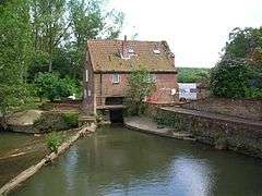 The Old Corn Mill at Buttercrambe is now a private home |
|
 Buttercrambe |
|
| OS grid reference | SE732581 |
|---|---|
| – London | 170 mi (270 km) S |
| Civil parish | Buttercrambe with Bossall |
| District | Ryedale |
| Shire county | North Yorkshire |
| Region | Yorkshire and the Humber |
| Country | England |
| Sovereign state | United Kingdom |
| Post town | YORK |
| Postcode district | YO41 |
| Police | North Yorkshire |
| Fire | North Yorkshire |
| Ambulance | Yorkshire |
| EU Parliament | Yorkshire and the Humber |
| UK Parliament | Thirsk and Malton |
Coordinates: 54°00′50″N 0°52′59″W / 54.014°N 0.883°W
Buttercrambe is a small village in the Buttercrambe with Bossall civil parish, in the Ryedale district of North Yorkshire, England.[1][2]
The village is situated approximately 8 miles (13 km) to the north-east of York and on the border with the East Riding of Yorkshire. It, with Bossall parish had a recorded population of about 100 in the 2001 Census.
Aldby Hall and the Church of St John the Evangelist are at the centre of the village. To the west of Buttercrambe, on high ground, are the remains of a Roman Temporary Camp: a square enclosure, ditched and banked, constructed quickly by an army on manoeuvres in enemy territory and used either overnight or for a short period of time, and demolished upon abandonment of the site. The camp was constructed probably 20 years before the establishment of Eboracum, Roman York, in 71 AD.
Gallery
 Buttercrambe Bridge in c. 1910
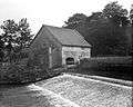 Buttercrambe Weir in c. 1910
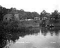 Buttercrambe Lock in c. 1910
References
- ↑ Ordnance Survey: Landranger map sheet 105 York & Selby (Map). Ordnance Survey. 2014. ISBN 9780319229453.
- ↑ "Ordnance Survey: 1:50,000 Scale Gazetteer" (csv (download)). www.ordnancesurvey.co.uk. Ordnance Survey. 1 January 2016. Retrieved 30 January 2016.
External links
 Media related to Buttercrambe at Wikimedia Commons
- Buttercrambe in the Domesday Book