River Aire
| River Aire | |
| River | |
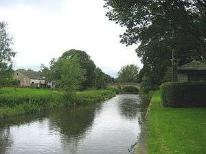 The River Aire at Gargrave, North Yorkshire | |
| Country | England |
|---|---|
| Counties | North Yorkshire, West Yorkshire, East Riding of Yorkshire |
| District | Craven |
| Tributaries | |
| - left | Gordale Beck, Eshton Beck, Eller Beck, Silsden Beck |
| - right | Otterburn Beck, Broughton Beck, Eastburn Beck, River Worth, Harden Beck, Bradford Beck, River Calder |
| City | Leeds |
| Source | |
| - location | Malham Tarn, North Yorkshire |
| - elevation | 377 m (1,237 ft) |
| Mouth | River Ouse |
| - location | Airmyn, East Riding of Yorkshire |
| - elevation | 5 m (16 ft) |
| Length | 148 km (92 mi) |
| Basin | 1,004 km2 (388 sq mi) |
| Discharge | for River Ouse |
| - average | 35.72 m3/s (1,261 cu ft/s) |
River Aire | |||||||||||||||||||||||||||||||||||||||||||||||||||||||||||||||||||||||||||||||||||||||||||||||||||||||||||||||||||||||||||||||||||||||||||||||||||||||||||||||||||||||||||||||||||||||||||||||||||||||||||||||||||||||||||||||||||||||||||||||||||||||||||||||||||||||||||||||||||||||||||||||||||||||||||||||||||||||||||||||||||||||||||||||||||||||||||||||||||||||||||||||||||||||||||||||||||||||||||||||||||||||||||||||||||||||||||||||||||||||||||||||||||||||||||||||||||||||||||||||||||||||||||||||||||||||||||||||||||||||||||||||||||||||||||||||||||||||||||||||||||||||||||||||||||||||||||||||||||||||||||||||||||||||||||||||||||||||||||||||||||||||||||||||||||||||||||||||||||||||||||||||||||||||||||||||||||||||||||||||||||||||||||||||||||||||||||||||||||||||||||||||||||||||||||||||||||||||||||||||||||||||||||||||||||||||||||||||||||||||||||||||||||||||||||||||||||||||||||||||||||||||||||||||||||||||||||||||||||||||||||||||||||||||||||||||||||||||||||||||||||||||||||||||||||||||||||||||||||||||
|---|---|---|---|---|---|---|---|---|---|---|---|---|---|---|---|---|---|---|---|---|---|---|---|---|---|---|---|---|---|---|---|---|---|---|---|---|---|---|---|---|---|---|---|---|---|---|---|---|---|---|---|---|---|---|---|---|---|---|---|---|---|---|---|---|---|---|---|---|---|---|---|---|---|---|---|---|---|---|---|---|---|---|---|---|---|---|---|---|---|---|---|---|---|---|---|---|---|---|---|---|---|---|---|---|---|---|---|---|---|---|---|---|---|---|---|---|---|---|---|---|---|---|---|---|---|---|---|---|---|---|---|---|---|---|---|---|---|---|---|---|---|---|---|---|---|---|---|---|---|---|---|---|---|---|---|---|---|---|---|---|---|---|---|---|---|---|---|---|---|---|---|---|---|---|---|---|---|---|---|---|---|---|---|---|---|---|---|---|---|---|---|---|---|---|---|---|---|---|---|---|---|---|---|---|---|---|---|---|---|---|---|---|---|---|---|---|---|---|---|---|---|---|---|---|---|---|---|---|---|---|---|---|---|---|---|---|---|---|---|---|---|---|---|---|---|---|---|---|---|---|---|---|---|---|---|---|---|---|---|---|---|---|---|---|---|---|---|---|---|---|---|---|---|---|---|---|---|---|---|---|---|---|---|---|---|---|---|---|---|---|---|---|---|---|---|---|---|---|---|---|---|---|---|---|---|---|---|---|---|---|---|---|---|---|---|---|---|---|---|---|---|---|---|---|---|---|---|---|---|---|---|---|---|---|---|---|---|---|---|---|---|---|---|---|---|---|---|---|---|---|---|---|---|---|---|---|---|---|---|---|---|---|---|---|---|---|---|---|---|---|---|---|---|---|---|---|---|---|---|---|---|---|---|---|---|---|---|---|---|---|---|---|---|---|---|---|---|---|---|---|---|---|---|---|---|---|---|---|---|---|---|---|---|---|---|---|---|---|---|---|---|---|---|---|---|---|---|---|---|---|---|---|---|---|---|---|---|---|---|---|---|---|---|---|---|---|---|---|---|---|---|---|---|---|---|---|---|---|---|---|---|---|---|---|---|---|---|---|---|---|---|---|---|---|---|---|---|---|---|---|---|---|---|---|---|---|---|---|---|---|---|---|---|---|---|---|---|---|---|---|---|---|---|---|---|---|---|---|---|---|---|---|---|---|---|---|---|---|---|---|---|---|---|---|---|---|---|---|---|---|---|---|---|---|---|---|---|---|---|---|---|---|---|---|---|---|---|---|---|---|---|---|---|---|---|---|---|---|---|---|---|---|---|---|---|---|---|---|---|---|---|---|---|---|---|---|---|---|---|---|---|---|---|---|---|---|---|---|---|---|---|---|---|---|---|---|---|---|---|---|---|---|---|---|---|---|---|---|---|---|---|---|---|---|---|---|---|---|---|---|---|---|---|---|---|---|---|---|---|---|---|---|---|---|---|---|---|---|---|---|---|---|---|---|---|---|---|---|---|---|---|---|---|---|---|---|---|---|---|---|---|---|---|---|---|---|---|---|---|---|---|---|---|---|---|---|---|---|---|---|---|---|---|---|---|---|---|---|---|---|---|---|---|---|---|---|---|---|---|---|---|---|---|---|---|---|---|---|---|---|---|---|---|---|---|---|---|---|---|---|---|---|---|---|---|---|---|---|---|---|---|---|---|---|---|---|---|---|---|---|---|---|---|---|---|---|---|---|---|---|---|---|---|---|---|---|---|---|---|---|---|---|---|---|---|---|---|---|---|---|---|---|---|---|---|---|---|---|---|---|---|---|---|---|---|---|---|---|---|---|---|---|---|---|---|---|---|---|---|---|---|---|---|---|---|---|---|---|---|---|---|---|---|---|---|---|---|---|---|---|---|---|---|---|---|---|---|---|---|---|---|---|---|---|---|---|---|---|---|---|---|---|---|---|---|---|---|---|---|---|---|---|---|---|---|---|---|---|---|---|---|---|---|---|---|---|---|---|---|---|---|---|---|---|---|---|---|---|---|---|---|---|---|---|---|---|---|---|---|---|---|---|---|---|---|---|---|---|---|---|---|---|---|---|---|---|---|---|---|---|---|---|---|---|---|---|---|---|---|---|---|---|---|---|---|---|---|---|---|---|---|---|---|---|---|---|---|---|---|---|---|---|---|---|---|---|---|---|---|---|---|---|---|---|---|---|---|---|---|---|---|---|---|---|---|---|---|---|---|---|---|---|---|---|---|---|---|---|---|---|---|---|---|---|---|---|---|---|---|---|---|---|---|---|---|---|---|---|---|
Legend
| |||||||||||||||||||||||||||||||||||||||||||||||||||||||||||||||||||||||||||||||||||||||||||||||||||||||||||||||||||||||||||||||||||||||||||||||||||||||||||||||||||||||||||||||||||||||||||||||||||||||||||||||||||||||||||||||||||||||||||||||||||||||||||||||||||||||||||||||||||||||||||||||||||||||||||||||||||||||||||||||||||||||||||||||||||||||||||||||||||||||||||||||||||||||||||||||||||||||||||||||||||||||||||||||||||||||||||||||||||||||||||||||||||||||||||||||||||||||||||||||||||||||||||||||||||||||||||||||||||||||||||||||||||||||||||||||||||||||||||||||||||||||||||||||||||||||||||||||||||||||||||||||||||||||||||||||||||||||||||||||||||||||||||||||||||||||||||||||||||||||||||||||||||||||||||||||||||||||||||||||||||||||||||||||||||||||||||||||||||||||||||||||||||||||||||||||||||||||||||||||||||||||||||||||||||||||||||||||||||||||||||||||||||||||||||||||||||||||||||||||||||||||||||||||||||||||||||||||||||||||||||||||||||||||||||||||||||||||||||||||||||||||||||||||||||||||||||||||||||||||
The River Aire is a major river in Yorkshire, England, 148 miles (238 km) in length.[1] In the Handbook for Leeds and Airedale (1890), it notes that the distance from Malham to Howden is 58 miles (93 km) direct, but the river's meanderings extend that to 90 miles (140 km).[2] Part of the river below Leeds is canalised, and is known as the Aire and Calder Navigation.
Course
The Aire starts its journey at Malham Tarn. It becomes a subterranean stream at 'Water Sinks' about 1 mile (1.6 km) before the top of Malham Cove, it then flows underground to Aire Head, just below Malham, in North Yorkshire, and then flows through Gargrave and Skipton. After Cononley, the river enters West Yorkshire where it passes through the former industrial areas of Keighley, Bingley, Saltaire and Shipley. It then passes through Leeds and on to the villages of Swillington and Woodlesford. At Castleford is the confluence of the Aire and Calder; just downstream of the confluence was the ford where the ancient British road, used by the Romans, crossed on its way north to York. The river re-enters North Yorkshire near Knottingley and in its lower reaches forms part of the boundary between North Yorkshire and the East Riding of Yorkshire.
The River Aire empties into the River Ouse at Airmyn, 'myn' being an old English word for 'river mouth'.[3] The name possibly derived from Common Brittonic *Isara, meaning "strong river". The Aire could have been the winwœd or winwæd written about in Old English, from the Old English elements winnan or win ("strife", "fight") and wæd ("shallow water", "ford"), however others have proposed that it is actually the Went (also called the "wynt" in Old English) or the Cock Beck (see Battle of the Winwaed). Still others have claimed that it is actually the name of the battle and not the body of water itself.[4][5]
Between Malham Tarn and Airmyn, the river drops 400 metres (1,300 ft).[6]
Tests have been conducted to authenticate the actual source of the Aire. The tarn at Malham has been dammed and then allowed to flood. Observers have noted that whilst water surged at Aire Head, it also surged at the bottom of Malham Cove. There was a significant difference of 30 minutes between the two surges with Malham Cove being slower to react to the floodwater.[7]
The section between Malham Tarn and the confluence of the becks at Aire Head is known as Malhamdale.[8] Thereafter the valley is known as Airedale and encompasses Bradford, (even though the river bypasses the city) and by the time it reaches Leeds, the term Airedale is rarely applied.[9]
Settlements
from source
- Malham
- Hanlith
- Airton
- Bell Busk
- Gargrave
- Skipton
- Low Bradley
- Cononley
- Kildwick
- Silsden
- Steeton
- Utley
- Keighley
- Riddlesden
- Crossflatts
- Bingley
- Saltaire
- Shipley
- Charlestown
- Esholt
- Apperley Bridge
- Horsforth
- Kirkstall
- Holbeck
- Leeds city centre
- Knowsthorpe
- Allerton Bywater
- Castleford
- Brotherton
- Ferrybridge
- Knottingley
- Beal
- West Haddlesey
- Chapel Haddlesey
- Temple Hirst
- Hensall
- Gowdall
- Snaith
- Rawcliffe
- Newland
- Airmyn
(Joins River Ouse)
History
The Aire was forded by a paved way by the Romans at Castleford. The Roman Road connected Doncaster with York and went north through the town near to the church.[10][11] At this time, the River Don emptied into the Aire at Snaith, but the dutch engineer, Cornelius Vermuyden, changed the course of the Don in the 1630s so that it flows into the Ouse after its confluence with the Aire.[12]
An Act of Parliament was passed in 1699 to make the river downstream of Leeds navigable (the Aire and Calder Navigation) with a further act to extend the navigable part of the river upstream to Bingley. This second act formed the basis of the Leeds and Liverpool Canal.[13]
Between the middle part of the nineteenth century to the latter part of the twentieth, the River Aire was devoid of fish life downstream of Shipley due to its pollution. Efforts have been made to return the river to a good wildlife status and fish and other wildlife now do exist all along the course of the river.[14]
Power stations
There are three power stations alongside the River Aire east of Castleford; Ferrybridge C, Eggborough[15] and Drax. Drax takes its cooling water from the Ouse, but both Ferrybridge and Eggborough draw their water from the Aire. Both of these plants stopped generating in 2016,[16] with Eggborough being a stand-by for capacity problems until March 2017.[17]
Ecology
Due to the Aire flowing through the former industrial landscape of West Yorkshire, it had a reputation as being heavily polluted.[18] In 2007, Yorkshire Water carried out improvements to Esholt Sewage Works at a cost of £110 million under the EU's Fresh Water Fish Directive. Whilst Trout are prevalent above Keighley, the river is host to others such as Chub, Dace, Barbel & Grayling, whilst Sea Trout have been noted as far upriver as Shipley.[19] Work is also being undertaken to make the many weirs on the river easier to negotiate for fish.[20] These improvements have also allowed Otters and Water Voles to return to the river as the water and food quality is far superior to that when the river was polluted.[21]
Castleford Wastewater Treatment Works has had £16 million of investment between 2013 and 2015. The improvements to this plant, which discharges water directly into the Aire, has also vastly improved water quality downstream of the plant.[19]
Rodley Nature Reserve, Kirkstall Valley Nature Reserve, St Aidans and Fairburn Ings RSPB reserve all lie alongside the Aire.
Navigation
The Aire is navigable as far upstream as Leeds and downstream has a navigable section into the Aire & Calder Navigation, with navigable access to other canals and waterways. Crown Point in Leeds is listed as the furthest west that can be reached by boat, though the limit is a headroom of 11 feet 11 inches (3.62 m).[22] The weir that straddles Crown Point is a listed structure having been constructed in medieval times and first documented in 1636.[23]
Canoeing and rowing are popular sports on the river with at least two clubs (the Bradford and Bingley Canoe Club and the Bradford Amateur Rowing Club) having landings on the river. Canoeing can be carried out on most parts of the river, with the two clubs having navigable sections protected by weirs next to their landings.[24][25]
Gallery
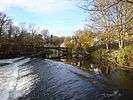
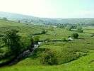 South of Malham
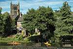
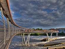 The 2008 bridge over the River Aire at Castleford
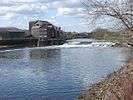
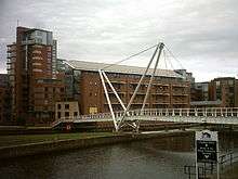
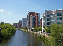 River Aire at Leeds
 Pollard Bridge, Newlay near Leeds
 The River Aire as it approaches the River Ouse at Airmyn
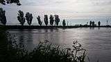 The confluence of the River Aire and River Ouse. The Aire emerges from the left.
See also
References
- ↑ "River Aire Factfile" (PDF). Environment Data. Environment Agency. p. 2. Retrieved 15 November 2016.
- ↑ Miall 1890, p. 40.
- ↑ Ekwall, Eilert. The concise Oxford dictionary of English place-names (4 ed.). Oxford: Clrendon Press. p. 4. OCLC 400936.
- ↑ "A Brief History of the Fairburn Area". Web.onetel.net.uk. Retrieved 5 August 2011.
- ↑ Archaeologia Aeliana, Or, Miscellaneous Tracts Relating to Antiquity By Society of Antiquaries of Newcastle upon Tyne Published by Society of Antiquaries of Newcastle upon Tyne, 1857 Item notes: ns.1 Original from Oxford University Digitized 24 January 2007
- ↑ Speight, Harry (1891). "Table of altitudes". Through Airedale from Goole to Malham. Leeds: Walker Laycock. p. ixiv. OCLC 5824116.
- ↑ Miall 1890, p. 3.
- ↑ "Strategic Flood Risk Assessment" (PDF). North Yorkshire County Council. p. 9. Retrieved 15 November 2016.
- ↑ Ayto, John; Crofton, Ian (2005). Brewers Britain & Ireland. London: Weidenfield & Nicholson. p. 14. ISBN 0-304-35385-X.
- ↑ Speight, Harry (1891). "Table of altitudes". Through Airedale from Goole to Malham. Leeds: Walker Laycock. p. 39. OCLC 5824116.
- ↑ "Roman Castleford" (PDF). Wakefield.gov.uk. p. 2. Retrieved 14 November 2016.
- ↑ Miall 1890, p. 39.
- ↑ "River Aire". Canal & River Trust. Retrieved 15 November 2016.
- ↑ "Kirkstall Valley Weir Fish Passes" (PDF). Aire Rivers Trust. Retrieved 15 November 2016.
- ↑ "Lubrafil" (PDF).
- ↑ "Ferrybridge C Power Station officially closes after 50 years". BBC News. 31 March 2016. Retrieved 15 November 2016.
- ↑ "Reprieve for threatened Eggborough Power Station". BBC News. 8 February 2016. Retrieved 15 November 2016.
- ↑ "A brief history of the River Aire". Aire Rivers Trust. Retrieved 24 November 2015.
- 1 2 "Waste Water". Yorkshire Water. Retrieved 21 October 2015.
- ↑ "River Water Quality". Yorkshire Water. Retrieved 21 October 2015.
- ↑ "Pollution is water under the bridge". Keighley News. Retrieved 20 October 2015.
- ↑ "Canal & River Trust - Aire & Calder Canal" (PDF).
- ↑ Historic England. "Leeds dam on River Aire (1375063)". National Heritage List for England. Retrieved 15 November 2016.
- ↑ White, Clive (7 April 2010). "Bingley canoeists are going for gold". Telegraph & Argus. Retrieved 15 November 2016.
- ↑ "Home". Bradford Amateur Rowing Club. Retrieved 15 November 2016.
Bibliography
External links
| Wikimedia Commons has media related to River Aire. |
- A Facebook page dedicated to recording images of River Aire
- The website of The Aire Rivers Trust who are dedicated to improving the river and its catchment
- EU Fresh Water Fish Directive
- Fact File on River Aire
Coordinates: 53°43′N 0°53′W / 53.717°N 0.883°W